24th May 2025: Megalithic (self-guided) Tour {Malta, May 2025}

The group of drunk people was back again, at 5:00 once more. Joy. However, this time I could not get an early start because I had booked a Megalithic Tour with a company called Visit Malta, as at first it had felt more convenient than navigating the buses. They confirmed and sent me a ticket saying that pick up was at my hotel, and a Google Maps link that did not work. Thus, I assumed that they would pick me up at the hotel. I tried to contact them via email previously, but I had no reply, so I told myself not to be paranoid, and trust them.

Twenty minutes after the pick up time, I called them. They yelled at me that I was in the wrong place. I informed them that my ticket read “pick up at the hotel”. They told me there was nothing they could do for me. So I was upset for about 3 minutes – that was 50 € down the drain. However, it was only 9:30 in the morning, so I had time to take matters in my own hands and go see the temples on my own. And I could even squeeze an extra one! I felt… I don’t know… gleefully spiteful. I was going to see the temples out of revenge! I know it sounds strange, but it took me back to what happened in Cappadoccia, when there was nothing I could do to fix the issue. This time around, I had lost some money, but I would not miss on the experience.

Of course, this would have been much more efficient if I had organised the visits originally on my own, since the Ħaġar Qim and Mnajdra Archaeological Park | Il-Park Arkeoloġiku Ta’ Ħaġar Qim u L-Imnajdra is in Qrendi | Il-Qrendi, quite close to the Blue Grotto. Conversely, that also made it easy for me to get there, since I knew the bus route already. But I decided not to dwell on the inconvenience and just “save back” the lost 50 € back not buying whims or mementos.

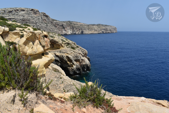
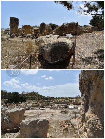
The Megalithic Temples of Malta are a World Heritage site, and it still blows my mind that they are older than either Stonehenge or the Giza Pyramids. The Ħaġar Qim and Mnajdra Archaeological Park | Il-Park Arkeoloġiku Ta’ Ħaġar Qim u L-Imnajdra might be the most well-known complex, or at least it was the one with most tourists.

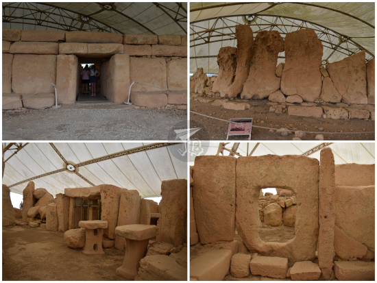
The temples Ħaġar Qim and Mnajdra are located very close to one another, and they share an entrance with a small museum, thus forming one archaeological park. Both were first officially described by officer J.G. Vance of the Royal Engineers (British Army) in the 1840s. Unlike Ħal Tarxien on Thursday evening, these two were packed with visitors – more than a few of them happily touching the stones out of curiosity or for support as they walked. I got there in bus 201 and reached the entrance just before a big tour bus entered. The guide lady tried to go past me, but my face must have told her that I was not in the mood to be messed up with, and my turn was respected. The museum mostly had information about the environment, and pieces of pottery that had been recovered from the sites – similar to what the Archaeological Museum in Valletta.

Ħaġar Qim was erected using the ever-present globigerina limestone, a soft sedimentary rock, golden in colour, formed around 23 – 14 million years ago. As this and other temples have weathered out, they have taken a more reddish or brown colour. To protect the remains from deterioration, many have been covered with protective tents.

The temple has several inner chambers within a retaining wall that can be crossed through a trilithon. The whole site has a keyhole shape, and it has been associated with fertility rituals. The main temple was built between 3600 and 3200 BCE, with remains of older ruins. As construction went on, the shape became distorted. It holds the largest stone in any of the Maltese temples, and an altar probably for animal sacrifices. It was hard to get into the magnificence of the temples with so many people swarming them after the Ħal Tarxien experience. However, the structure is quite impressive in itself.

Hagar Quim Neolithic temple: a roundish construction surrounded by a wall made out of limestone. Inside there are chambers and open holes working as doors, along a thriliton as main gate.

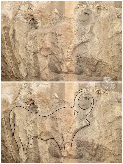
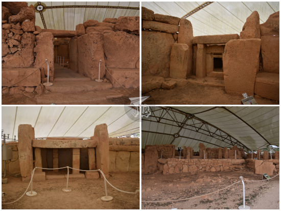
Mnajdra | L-Imnajdra is made from coralline limestone, a harder kind of stone, so as a construction material, it can be used in smaller blocks. Mnajdra might be the most representative temple in the archipelago, as its altar is depicted in Malta’s 1, 2 and 5-cent coins – though it is not the one which kickstarted the Unesco protection. Mnajdra consists on three temples arranged in a clover-leaf disposition. The structures are joined but not connected. They were erected between 3600 and 2500 BCE – so they could be over 5,600 years old. Even with the sheer amount of people around, there was something special about the complex. The temple plays light tricks on the equinoxes and solstices, and the decoration of one of the stones could be interpreted as a lunar calendar (with a lot of imagination, if you ask me). Probably, out of all the temples I visited, this one was the one I found more impressive – even if the first one I saw will forever remain my emotional-favourite.

Mnajdra Neolithic temple: a reddish limestonestructure with trilitons and low walls made out of brick-like structures

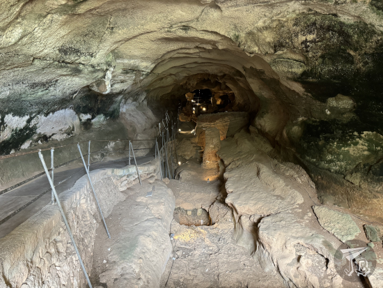
I was done before schedule, so I went back towards the bus stop. I returned to the airport and then took another bus (119) to Birżebbuġa. There I could see the Għar Dalam Cave and its museum. The Cave is home to some of the oldest evidence of human presence in Malta, around 7,400 years ago (the oldest comes from Mellieħa Cave, dated as 8,500 years old). Għar Dalam Cave is about 144 metres in length, and it also contains remains of animals that have been long extinct in the island, found in distinct layers of sediment at the bottom of the cave.

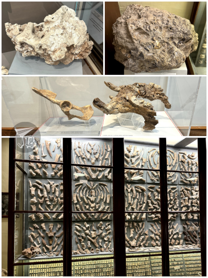
There is a base layer of clay, older than 167,000 years. Over that lies the “Hippopotamus layer”, showing remains of two extinct species of hippopotamus, deer, dwarf elephants… One of the hippos, Hippopotamus melitensis, was a “dwarf” hippo (only 900 kg) endemic to the island. The remains are very mineralised (almost fossils) and worn down. This is also called the “Breccia layer”. Breccia is a rock composed large angular fragments of minerals cemented by a fine-grained matrix, only in this case the fragments are ancient hippo bone.

Covering the “Hippopotamus Layer”, there is a band of pebbles, without any remains. Over that one lies the “Carnivora Layer”, with remains of several of the previous animals along with foxes, wolves, bears, and smaller creatures such as voles, shrews, bats, turtles… These range from around 167,3000 to 151,200 years ago, and are less mineralised and worn down, just like the following band: the “Deer Layer”. Here there are remains of three different species of deer, some bovines, equines, and small animals. The two upper layers, starting 7,200 years ago, hold remains of small wild animals, domestic animals – sheep, goats, pigs, cows and cats – pottery and other human artefacts, and human remains.

Għar Dalam was first investigated in 1865 by palaeontologist Arturo Issel. Subsequent researchers expanded the excavation and knowledge, identified an all-new species of dwarf hippopotamus, and systematised the museum adjacent to the Cave. Said museum, called the George Zammit Maempel Hall presents hundreds (thousands, maybe) of the remains dug up from the cave. However, the most important ones, amongst them the skull of a Neolithic child, were stolen in 1980. The Cave itself is creepy and damp, and the excavation shows the different layers for the spectator to see. One wonders what lies beneath the end of the visitable area… I would believe the cave be haunted much easily than the Grand Master’s Palace.

Ghar Dalam museum: samples of rock with bones, and cleaned bones and hundreds of small bones in display cabinets.

Ghar Dalam cave - deep cave with excavated ground where you can guess the layers of bones and remains.

Across the valley from the Cave, you can see the remains of a ruined Roman villa Ta’ Kaċċatura, but it cannot be reached, and it’s hard to distinguish rocks from the actual ruins.

By now, I had seen all the temples included in the original tour, so I had a bit of a victory moment. And yet, I had more to do. I loaded up on sun lotion, then headed towards the nearby Borġ In-Nadur, barely ten minutes away on foot – plus some extra to cross the street so you are on something similar to a pavement to walk on. Borġ In-Nadur is another small megalithic structure, with a cemetery, and the remains of a Bronze Age village, with remains ranging from the years 3000 to 700 BCE. Entrance to the Megalithic site was included with the visit of Għar Dalam. The temple was first excavated in the 1920s by archaeologist Margaret Murray. It is the most dilapidated site I visited, but I was again alone – except for a couple of chickens from an adjacent farm. You are allowed to go into the niche or stone circle, and unlike the other temples, it is not covered (yet?).

Borg in Nadur, a roundish collection of megaliths vaguely disposed in a circle

 
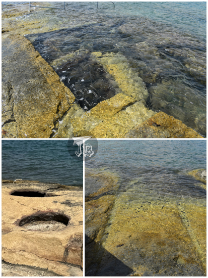
Near the temple, at the limestone beach of St George’s Bay | Il-Bajja ta’ San Ġorġ, I found silos and cart ruts, also thought to date from the Bronze Age, and Roman Baths directly carved into the limestone. They are not really Roman baths, as in dating from Ancient Rome, these are artificial pools were excavated into the rock during Victorian times. And yet modern people think they’ve invented something

Different constructions near the sea shore: cart ruts, round silos and square artificial pools

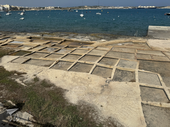
Not far from there, I found the bathing beaches, the commercial harbour and the salt pans, a traditional way to produce salt letting sea water evaporate from shallow pools in order to harvest the salt crystals. They did not seem in use though as they were either full of litter or used as sunbathing spots.

Rows of rectangular salt pans - shallow tidal pools - near the ocean

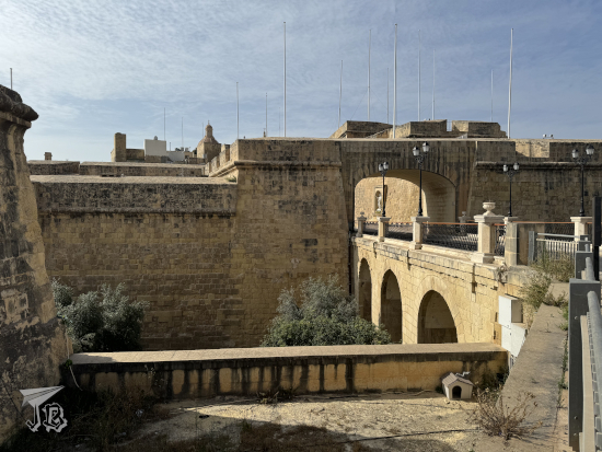
I still had some time and energy, and decided to invest them on getting to Birgu. This Medieval city is located across the Grand Harbour from Valletta, and it was the first place where the Knights Hospitaller settled. It has a bunch of historical palaces and museums. I would not get there before closing times, but at least I could see the town layout and some buildings from the outside. These included the Gate of Provence, the Inquisitor Palace, the Birgu Waterfront and Maritime Museum, and finally Fort Saint Angelo, a key fortress during the Siege of Malta. Today, use of the fort has been granted to the modern version of the Knights. There was a sign reading “Jurassic World: Dominion” was filmed here, but I did not recognise the backdrop.

Walled entrance to Birgu

Ruins of the Birgu Waterfront overlooking the ocean and Valletta

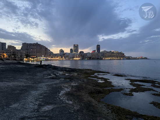
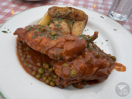
I found a convenient bus to head back to Saint Julian’s | San Ġiljan. I freshened up and headed for dinner. At first, I tried to get a table at a restaurant right at the entrance of the hotel. Since they decided to ignore me and give the table to someone else, I moved along. I found Salt & Pepper, a nice grill with an ocean view and an outdoor sitting area. There, I was able to try Stuffat tal-Fenek (fried rabbit in garlic), a typical Maltese recipe (considered the national dish, actually) – pan fried rabbit, simmered in wine, tomato paste, garlic, peas and olive oil, served with roasted potatoes. I wanted to try it, but at the same time I was a bit reluctant, as I am not a big fan of neither garlic nor wine. In the end, I have to say I enjoyed it more than I thought (as long as I kept my mind away from it being actually… rabbit).

Rabbit cooked in tomato sauce with peas and herbs, and wedged potatoes on the side.

Afterwards, I walked around Spinola Bay for some nice views before I turned in for a shower and some sleep… only to be woken up at 5:00. Again. But hey, this time it was a group of girls.

22nd May 2025: Blue Grotto, Tarxien & Saint Julian’s / Sliema {Malta, May 2025}

My flight departed at 9:55 from Madrid-Barajas, which is actually a very bad time for a flight, as you have to drive to the airport through the daily rush-hour traffic jam. However, for a change, I was given a lift there instead of driving myself – my car failed a few days before and I was not feeling too trusting. The inbound plane was delayed, and we ended up landing at Malta International Airport around an hour late.

It turns out that Malta has done a smart thing – the airport is also a coach hub, and there was a bus which went directly where I wanted to go first 20 minutes afterwards – that was lucky because the bus only comes every hour. It did not take long to reach the Blue Grotto | Taħt il-Ħnejja in the village of Qrendi | Il-Qrendi.

I got off in an aptly-named bus stopped called Grotto, next to which stands Xutu Tower | Torri Xutu. The history of Malta cannot really be understood without mentioning the Order of Knights of the Hospital of Saint John of Jerusalem, the Knights Hospitaller, today also known as the Sovereign Order of Malta. This Catholic military order was founded during the Crusades in the 12th century and the knights were established in Malta between 1530 and 1798, acquiring the name. They fortified the island and created the city and defences of Valletta, so-named after Grand Master La Valette. The knights built hospitals – along with medicine schools – and turned Valletta into a centre of art and culture with a university, a school of navigation, and a school of mathematics. Through the centuries, the order transitioned from a warring and defensive army to an organisation centred in humanitarian, medial and social assistance.

Xutu Tower | Torri Xutu was one of the towers built during the operation to fortify the coastline of Malta, probably around 1650. It is a two-story tower with a square ground plan and vaulted ceilings inside, setting the example of the towers that would be built afterwards. As many buildings in the island, the tower was erected using limestone, and restored in 2014 using the same type of material. It also yields to impressive sights – even without climbing it – of the ocean and the islet of Filfla, uninhabited and turned a bird sanctuary.

Qrendi cliffs, made if whiteish - grey rock, over a calm dark-blue ocean

I bought a ten-euro ticket to sail to the Blue Grotto | Taħt il-Ħnejja from the Blue Grotto Boat Service. This is just a way to amalgamate all the captains and boats who do trips to the caves, I think, and not a bad one. It is a quick trip that does not even take half an hour and charters you to snoop the different caves, created by the erosion of sea water and waves against the cliffs. Each has its name: Blue Window Cave, Circle Cave, Calscave, Honeymoon Cave, Cat’s Cave, Reflection Cave and the main archway which gives the name to the whole area, the Blue Grotto. The water is very clear and since the sun was out, there were extremely beautiful reflections. I stuck my hand in the ocean a few times when I was not taking pictures.

Blue Grotto: Sea level caves with bright blue water

Afterwards, I decided to stop for food. I was not really hungry, but I wanted to tackle the walk to the viewpoint, which was 15 minutes. I thought it would be more efficient to have a late lunch first. There were a couple of restaurants and I chose Step in Malta. It had a terrace, was less than half full, and most importantly: offered calamari fritti. When I researched Maltese food, I read about this dish – fried squid with garlic and parsley mayonnaise , and I really wanted to try them.. I think I broke the poor waiter’s brain when I told him I did not need the menu and ordered directly. They were delicious.

Calamari fritti: a plate of breaded and fried squid

I then did the short walk to the Blue Grotto Viewpoint – and though I won’t be mentioning it much, just assume I just used a lot of sun lotion all the time. It did not take as long as I expected, even if the shortcut was closed down. It yield to pretty views, but not as impressive as expected.

Blue Grotto viewpoint, showing the cliffs from above

I was about to go back towards the original spot to wait for the 201 bus again, when a Valletta-bound bus stopped by. I hopped onto that one to use the Wi-Fi and replan the rest of my evening. An idea had been to head towards Valletta indeed, but instead I decided to try my luck to reach my first Megalithic temple in Tarxien | Ħal Tarxien. The Blue Grotto is actually quite near another archaeological complex, but that one was covered by the tour I had booked on Saturday.

The trip to Tarxien turned out to be a great idea. When I arrived, I was surprised by the sheer amount of Christian images that were in the streets. That weekend the Catholics celebrated the Feast of the Annunciation. Malta is officially a Catholic country with over 80% of the population adhering to the religion, so while it was slightly surprising to see so much decoration, it is not shocking. I wanted to get to the Ħal Tarxien Prehistoric Complex | Il-kumpless Preistoriku ta’ Ħal Tarxien because it had a closing time.

A street crossing in Tarxien, with a movable Catholic altar brought out. The houses on the corners have flags with religious motives, and the altar is guarded by angels carved in wood

The Megalithic Temples of Malta are considered amongst the oldest free-standing structures in the world. They were erected between 4100 and 2500 BCE (making them older than Stonehenge, whose rocks were placed between 2600 and 2400 BCE), though the remaining structures probably date from the 3600 – 2200 BCE. In 1980, the UNESCO created the Heritage protection for one of the temples, and in 1992, the Site expanded to six temples / structures in total.

The Ħal Tarxien Prehistoric Complex | Il-kumpless Preistoriku ta’ Ħal Tarxien has been dated between 3000 – 2500 BCE, and it is considered the greatest example of the Temple Period (4100 – 2500 BCE). It was first excavated by Maltese archaeologist Themistocles Zammit around 1913 following complaints of a local farmer that he kept hitting stone while ploughing. The main excavation and restoration took place between 1915 and 1920, and some of the most delicate structures were moved to the Malta Museum of Archaeology to protect them from weathering. The site is covered by a protective tent that makes it look a bit alien, and being alone made it even more magical.

The temple is built in limestone, showcasing three constructions which are independent but attached to one another. The rooms are round, and there is evidence that they had a roofing. There are several chambers, and in some of them there are spiral decorations and domestic animals carved into the rock. There is even a small hearth where fire could be lit. I spent about an hour there, nearing closing time, which meant I was almost alone. I was extremely happy to be there.

Hal Tarxien temples - ruins of Neolithic temples with round rooms and trilithon entrances, from outside

Hal Tarxien temples - ruins of Neolithic temples with round rooms and trilithon entrances, from inside, showing spiral decorations and areas that have been restored, such as a hearth

Relief of a bull on a limestone wall

I could not visit the related Hypogeum of Ħal-Saflieni because tickets are released – and sold – months in advance, and this whole trip was planned in a couple of weeks. But I could explore around.

Due to the festivities, some of the bus stops were out of order, so I followed the bust route until I found one that was in use. At some point there I crossed my first “invisible frontier” between the village of Tarxien and Paola. Still in Tarxien, I stopped to look at the Catholic sculptures, and in Paola, I came across the Minor Basilica of Christ the King | Il-Bażilika ta’ Kristu Re. The church was erected at the beginning of the 20th century and, compared to the buildings around it, it feels huge – over 80 metres long, 40 metres wide and 60 metres high. It was full, which I found strange for a weekday at 18:00, but then I thought it might be part of the Feast of the Annunciation programme.

Minor Basilica of Christ the King: a Neoclassical basilica with two towers on the outside, and a sober interior design

I took a bus again and after a few changes I reached my hotel in the town of Saint Julian’s | San Ġiljan. Though I was driven through a few towns, it felt like a huge stride of buildings one after the other, with no real break. It was weird, that the whole area is just one big urban sprawl. I found changing buses easier than I expected, even not knowing the layout of the area. I got to my stop, Ballutta and checked into my hotel.

Aaand at that point I realised that there was a consequence of “British colonisation” that had not even crossed my mind – Malta has Type G plugs. So on my supermarket run I had to add an adaptor (despite having a few at home) to my bottled water and sandwich shopping list. I dropped the groceries at the room and then I went off to explore the coastline. That way, I inadvertently crossed to Sliema. I walked along Ballutta Bay and Exiles Bay, two of the three lobes that make up the larger St Julian’s Bay. I was a bit surprised when all the beaches were made of rock and limestone, which made them great to walk on. I had a lovely walk – except at one point, when I slipped and realised that my totally-sensible-for-airport shoes were not the best choice for limestone beaches. Eventually, I went back to the hotel to eat my supermarket-bought dinner.

Balluta Bay at dusk. The ocean is calm, and the buildings at the other side of the water have started turning on their lights

22nd – 26th May 2025: A taste of Malta {Malta, May 2025}

Last-minute trips are weird. You start looking at an Ireland itinerary, but for some reason hotels are 200€ a night. You check for alternatives and end up booking at a place you had never considered before. In my case, it was the tiny country of Malta, an archipelago with eight islands: Malta, Gozo | Għawdex, Comino | Kemmuna, Manoel Island | Il-Gżira Manoel, Cominotto | Kemmunett, Saint Paul’s Island | Il-Gżejjer ta’ San Pawl, Filfla and Filfoletta. It turns out that Malta is both the country and the main island. Only Malta, Gozo and Comino, that is inhabited – and there are just two people living in the latter.

Malta is located in the Mediterranean Sea, a handful of kilometres south of Sicily. It is one of the smallest, and most densely-populated countries in the world – actually, in the island of Malta you literally cannot tell where one city ends and the next begins. The inhabitants speak English and Maltese (I will use this order for bilingual references, English | Maltese, as I did above with the island names). Malta as an independent country was established in 1964, when it gained independence from the United Kingdom.

Humans first reached Malta during the Mesolithic, around the year 6500 BCE. Due to the island’s geostrategic location in the middle of the Mediterranean, it has been lusted after by many powers and alliances – from the Phoenicians, Greeks and Romans to the British Empire and everyone involved in WWII. The successive populations have heavily influenced the islands and its architecture.

My original plan was to stay in Valletta, a fortified city mostly from the 16th century and the capital of the country. However, I only found apartments in basements for a decent price. I finally found a hotel in Saint Julian’s | San Ġiljan. Once that was booked, I focused on what to do and see in Valletta, but the more I read about the island, the more intrigued I grew.

In the end, I decided to balance some landscape watching (22nd and 26th) with historical Valletta (23rd), prehistoric ruins (24th) and a guided tour through the smaller island of Gozo (25th). There were a few things that did not work out as intended, but all in all it was a good trip with lots of new experiences, but a tad of necessary improvisation made it less efficient than it could’ve been. Fortunately, everything that went wrong could be fixed.