
I had booked a second tour, in order to get to know the Island of Gozo. This time around though I had a very clear pick-up point, which I hoped would work out, unlike the previous day. Fortunately, the instructions from Gozo Tours were extremely clear and I knew exactly where the pick up point was, without any non-working links. There were other people from my same hotel, so we got nervous together. The driver was not too late though. We were driven in a mini-van towards the passenger terminal in the north of the island, Cirkewwa. There, we waited for pick-ups from other parts of the island. We had a charter high-speed boat that crossed the Gozo Channel and dropped us off at the Mgarr Harbour terminal in the second-biggest island of Malta (country).
Gozo | Għawdex is less urban than the Island of Malta, so I had decided that maybe the Full Day Jeep Safari Of Gozo could be a good way to get a feeling of the island, without having to plan much and depend on public transport. In hindsight, it was probably unnecessary but it eliminated the need to plan. All in all, the tour was convenient, but not something I would choose again – the landscapes were beautiful and dramatic, but not as crazy as I had expected.
I became really amused at how many people (read: most everyone) were unaware of the speed a speedboat reaches. I was glad that the boat was so fast; it glided over the wind-waves, and there was no swaying. That was good, because said wind would have made the trip miserable at a slower speed. However, there was a group of Italian girls who were absolutely petrified.
We reached Mgarr Harbour in Gozo and separated into small groups for the different jeeps. I was placed with four Londoners and an English guide, which suited me just fine. I don’t remember whether I actively chose the English-speaking tour, or I got assigned to one because I used the English webpage. There must have been tours in other languages. Apparently, all the jeeps go to the same spots at different times of the day so they don’t run into each other, so we followed a bit of a zigzagging route, with specific spots in different cities and towns. The information said there would be a “swim stop” during summer, I was just not sure whether the 25th of May would count as summer. I carried my swimsuit and towel anyway.
The first stop was barely five minutes in: Qala Belvedere, a panoramic spot in the town of Qala, which allowed us to catch sight of Comino, the third-biggest island in the archipelago. Afterwards, we got back on the jeep and headed off towards Ramla Bay in Xaghra. As he was describing the landscape, the guide at some point mentioned volcanic rock, which threw me off, as I believed that the islands were sedimentary. I thought maybe he meant there was some tuff. However, everything I have read about the geology of the islands agrees – the whole of them is sedimentary rock, in five main strata. From oldest, at the bottom, to newer, these are coralline limestone (Żonqor), globigerina limestone (Franka), blue clay mudstone (Tafal), greensand sandstone (Ġebla s-Safra) and coralline limestone again (Qawwi ta’ Fuq).
The Upper Coralline limestone formation (the most recent) is pale and grey, and it is embedded with biological structures. The most important rock is the globigerina limestone, which is golden and between 23 and 14 million years old. It is called so because it contains a lot of globigerina – a type of plankton – fossils (I did see a lot of shells in the rocks, but I was not carrying anything to dig the fossils out). This is the majority of building material in the country, even in a lot of the prehistoric temples. It has been designated a Global Heritage Stone Resource, something I did not even know existed until now. The blue clay is also key in Gozo as it is the one that allows for the creation of freshwater aquifers through the filtration of rainwater. The thing with limestone is that it erodes very dramatically, creating very capricious forms which are the base of the striking landscapes in the island.
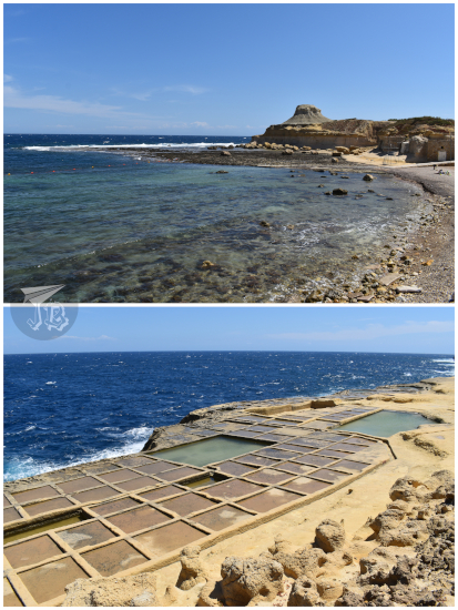
The shore of Ramla Bay is one of the few sand beaches in the country. It is called Ramla il-Ħamra (Red Sands) because of its reddish colour due to the presence of iron clay in the area. The beach is locked by two rocky formations / cliffs that protect it from the waves – unfortunately, not from real estate developers.

We continued towards Xwejni Bay in Żebbuġ. It has a small beach of pebbles, with a promontory to one of the sides, and a dramatic walk along the other side which leads to the salt pans. Unlike the ones from Birżebbuġa, these pans are commercially exploited. Between May and September, each pool is filled, individually and manually, with sea water which proceeds to evaporate and leave behind the dry salt crystals. With good weather, salt can be harvested once a week, and it is sold as flakes without further processing – rather nice, I’d say. We also were shown to a small shop that had tastings in hopes you bought stuff, and I did try the salt and the oil.
We drove by Basilica of the Blessed Virgin Of Ta’ Pinu | Santwarju Bażilika tal-Madonna ta’ Pinu, though we did not stop. The current building is Neo-Romanesque – construction started in the 1920s – and it looks like something from a fantasy cartoon. However, it is a serious Catholic temple, dating back from the 16th century at least, even if it kind of stands in the middle of nowhere.
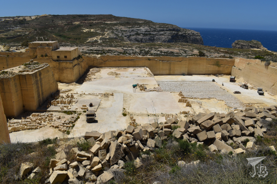
We crossed the town of Għarb and made a short stop at the SG 8 globigerina limestone quarry. It made me sad that the SG did not stand for “Stargate” but what can you do? The quarries through the island extract the rock which is used as construction material in many buildings through the country.
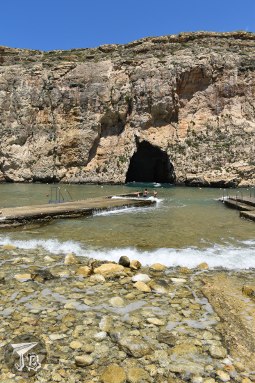
Instead of going to the other side of the galaxy, we headed off to San Lawrenz to see the Inland Sea | Qawra, a lagoon connected to the sea through a cave fault in the cliffs. When the weather is nice, there are boats giving you a ride past the archway and out to the sea, but not this time around – there were some pretty decent waves coming in, so it was too dangerous to sail the crossing.
We drove through Għarb again, where I could catch a glimpse of the Basilica and Collegiate Parish church of the Visitation of Our Lady, and continued towards Xewkija where we were to have a “three-course course light lunch”. This consisted on a Ricotta Pastizz (pastry stuffed with ricotta cheese), Maltese Bragioli | Beef Olive (stuffed beef roll), and vanilla ice-cream, along with wine that I did not have, I went for water instead. Food was all right, I was not hungry so it was fine. Afterwards, the guide offered to take us to a gelateria to have “the best ice-cream ever”.

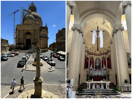
Before that, we crossed the scorching square to see the Rotunda St. John Baptist Church | Basilika St. Johannes der Täufer, which had recently been struck by lightning. This is a Baroque church established in 1678, though the building was erected in limestone in the mid-20th century. The new building actually encased the original church, which now is a small chapel to the left side of the main altar. St John is the Spiritual Seat of the Knights Hospitaller.
The next stop was Xlendi Bay and the beach town of Xlendi. There stands Xlendi Tower, built by the Knights in 1650, restored in 2010. The natural landscape was stunning, but the town itself was just a touristy beach town. The promised ice-cream parlour was a chain called Gelateria Granola, where I decided to try the cookie ice-cream, because it was something I had never come across before, and I had next to no time to choose, it felt – I have no idea how I ended at the front of the crowd.

Ice-cream happily consumed, we drove off. We stopped in Fontana where there is a natural water spout called the Knight’s Wash House, halfway between a historical landmark and a local fountain. As a curiosity it was all right. We continued to Victoria, whose historical seed is called The Cittadella | Iċ-Ċittadella, the Citadel. The area comprising the Cittadella was first inhabited during the Bronze Age, and it probably went on to become the Roman acropolis and eventually a castle in the Middle Ages. The castle defences were reconstructed in the 17th century, but they were not considered the best – the Cittadella actually surrendered in the 1798 French invasion and counterstrike, without much resistance either time.
Our allotted time there felt too long for just a walk and too short to the whole thing, unfortunately, so I could not snoop around the museums. Furthermore, the Cathedral of the Assumption – The Matrix, Parish Church, Sanctuary, Collegiate and Cathedral of the Assumption of the Blessed Virgin Mary into Heaven | Parrocca Matrici, Arcipretali, Santwarju, Kollegjata Insinji u Katidral ta’ Santa Marija Assunta was closed. The whole area looked like it would be awesome to be able to sleep over there – especially because walking uphill to visit it would be hard in the sun.

The hour approached to head back to the quay. We started making our retreat with two short stops on the way, in the town of Għajnsielem. The first one was for the guide to take our pictures with the Monument to the bench in the village square, a metal bench showcasing a pair of grandparents, a young woman with a smartphone and a cat begging for attention. The bench is located in front of the Għajnsielem Parish Church. The second stop was a panoramic view of Gozo Straight and the Church of the Madonna of Lourdes | Knisja tal-Madonna ta’ Lourdes. There was no swim stop in the end, so late May is not summer yet. All in all, we started off around 10:00 and were done by 16:00, and it cost 80 €.
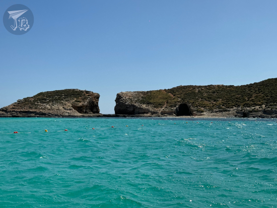
We made it back to Mgarr Harbour, where we took the speedboat back, first to drop off some passengers in Comino, which gave us a peek into the Blue Lagoon there. Again, I was glad for the speed, because the waves would have made a leisure trip miserable. Afterwards, we were driven back our points of origin. Back in my hotel, I snacked on some salt-and-vinegar crisps from my favourite British brand that I had found in the supermarket.
Around sunset, I went out to explore Saint Julian’s | San Ġiljan a little further. I had considered some of the typical restaurants there, but since I ate the crisps I was not hungry. What I did was walk around Spinola Bay, along Spinola Slipway and Saint Julian’s Promenade, and past the Fisherman Monument – with yet another cat begging. I tried to reach the marina, but it was all uphill and taken over by the luxury hotels.

Instead of dinner, I had another snack, and then headed off back for a shower, some sleep and… yes, another 5:00 wake up call. Talk about jet lag without changing your time zones!

