31st May 2022: Anaga {Tenerife, birthday 2022}

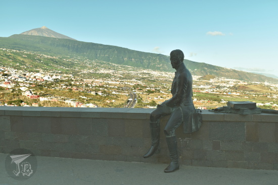
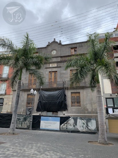
I got up on the early side as I had booked breakfast at 8:00. I was surprisingly not hungry, even if I had not finished dinner the previous evening. My plane was a little before 17:00 and I had to return the car at 13:30 (I must have messed up the time, because I was convinced I had chosen 14:30). however, there was still one spot in the island I wanted to check out – the Nature Reserve Parque Rural de Anaga, in the north of the island and about half an hour’s drive away from the airport. This is a mountain area covered in primitive subtropical moist broadleaf forests, called laurisilva canaria. The mountain range is the oldest part of the island of Tenerife.

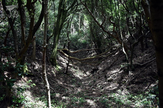
During the Tertiary Period, the whole Mediterranean area was covered in forests which had wide, dark leaves. They disappeared with the glacial era that started with the Quaternary. The forest has not changed nor evolved with time, so it has remained as it was 40 million years ago. It was preserved in several humid areas due to the wind patterns while the continents dried out and deserts opened. Sometimes, these forests are called laurel forests, as laurel (Laurus novocanariensis) is one of the typical plants. There are other trees as tils (Ocotea foetens), bushes, vines, ferns and mosses.

I drove around two hours to get from the Parador to Anaga, and was lucky to snatch one of the last parking spots. I asked at the visitor’s centre about a route that was not too long and I was recommended a two-hour one, called Bosque de los Enigmas, the Enigma Forest.

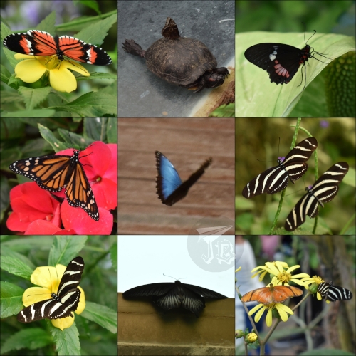
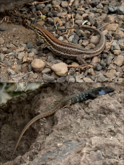
The beginning of it was really cool. The tils and the laurels twisted almost magically and I was alone on the path. I saw some birds, though capturing them on camera was hard, possibly a grey wagtail (Motacilla cinerea) and a female blackbird (Turdus merula; which is not really black). Aside from being a nature reserve, Anaga is also a bird protection area.

A path into the primitive forest. The trees curve over and around the trail, and everything is dark

A shot up a tree, the trunk is covered in moss

An old waterway or river bed turned into a path. There are walls of dirt to the side, and the roots of the trees are showing

Collage: a grey fluffy bird looking at the camera, and a black one with its back turned, completely ignoring it.

At some point, unfortunately, I lost the trail. I reached the viewpoint Mirador de Zapata going in the wrong direction. Though the weather was very appropriate for an evergreen subtropical forest, this meant that I could either backtrack, or go along the road for a while. I decided on the side of the road as that way I knew how long I would take to reach the parking lot.

A view of the tree tops from above. In the backgrond, partially obscured by the thick fog, there is a village, and the sea is beyond it.

I eventually reached the beginning of the trail again and I had not been run over a car, which was a plus, and before leaving I could look over a second viewpoint Mirador de la Cruz del Carmen, which offers a peek onto the whole massif.

Traces of water runoff paths, which have eroded the soil and torn some trees down

A view of the tree tops from above. In the backgrond, partially obscured by the thick fog, there is a village, and volcanic mountains beyond it.

After this, I drove back to the airport to turn back the car and have some lunch. I had hoped that the smaller airport would be less strict than one of the big hubs, but it turned out they were even more vigilant. So off with the shoes again. We took off at the brink of time, landed at the expected hour… and on the way back home got caught in an hour-long double traffic jam. Ho boy!

All in all, nothing really went according to plan, even if the plans were just a draft. But all in all I had a good time and got to spend some time with myself, which I desperately needed. So yay luckiest unlucky trip ever!

30th May 2022: The Slopes of Mount Teide {Tenerife, birthday 2022}

Due to the amount of near-misses, I had started thinking about this as the luckiest unlucky trip in a long time. Unfortunately, this was the day the luck ran out. As I woke up and turned on the phone I received the notification that the cable-car to go up Mount Teide was closed due to bad weather, which was a bit of a blow. I mean, I was in the middle of the natural park, without anything to do within a couple of hours by car as the hiking trails are closed on Monday mornings as it is then when the mouflon population is controlled – using rifles. I did not want to end up shot.

If you consider that the island Tenerife is one big volcano, Mount Teide is the most famous eruptive fissure. Considering it an independent item, it is a stratovolcano. The cone stands around 7500 metres from the sea floor, with an emerged 3715 m above sea level. Its base is located on a previous crater called Las Cañadas. Mount Teide last erupted in 1909, so it is still considered an active volcano, and it hosts a bunch of towns on its slopes, that might get obliterated in an eruption. Aside from being a National Park, the area is a Unesco World Heritage Site.

Historically, an eruption was reported by Christopher Columbus in 1492. Most recent eruptions happened in 2805, 1798 and 1909. Looking back, Mount Teide formed around 160,000 years ago, after the collapse of Las Cañadas. The last summit eruption happened in the 9th century, which caused the black lava blocks that seem to run down the slopes.

The whole point of my being there was going up the mountain, so I resolved to try and do that. I knew there was little chance I could make it to the top even with the access permission, but I would try. I decided to gamble the track Sendero de Montaña Blanca, which is the most typical one. For this, I had a good breakfast and started walking around 9:45 am. The track runs 8 km and starts at an altitude from 2348 m. If you have the permission, you can access the track Sendero de Telesforo Bravo that peaks the volcano at 3718 metres.

A stone and tile marker, with a map of the trail.

The first part of the morning, I spent on Montaña Blanca. I hiked around 3 km upwards in an hour or so. A park ranger told me that the bad weather was actually strong winds and to be careful. I’d never hiked with wind, so I decided that I would not do anything stupid. As I walked, I went by the accretion balls affectionately called “Teide Eggs” Huevos del Teide.

Collage: The Montaña Blanca trail. The landscape is desertic, reddish and brown, and there is barely any vegetation. When turning back, the sea peeks in the distance, and when looking up there are black rocks from an eruption.

Eventually, I reached the actual foot of Mount Teide, and this is when things got hard – and spectacular. The slope became much steeper and the wind made it hard to move forward. I walked between the two dark petrified lava flows, and could see Montaña Blanca and the Atlantic Ocean beneath.

View from the slope of Teide. Montaña Blanca is underneath, in red-gold. To the sides, the black and dark grey rocks trailing the old lava flows

I reached Refugio de Altavista at 3260 m around 14:00. At this point I was two kilometres away from the next station and 650 m away from the crater. Unfortunately, the elevation was still around 500 m. At this point the wind was very strong and shortly after the refuge I saw an area of the slope I knew I could climb up… but I knew I wouldn’t climb down with such strong wind, not safely. So I realised I had to turn back, even if that meant I wouldn’t see the peak, much less reach it. However, it was the sane thing to do.

Standing in the middle of the two solidified coladas - looking down there are black and grey rocks, and the sea in the horizon. Looking up, only more rocks.

It took me two and a half hours to hike down, and I made it back at the Parador around 17:30. I had a shower and I felt tired, though not as sore as I imagined. For dinner, I tried some local speciality “wrinkled potatoes” papas arrugadas, which are boiled in saltwater, and they are so high-class that can be eaten without being peeled. They come with some dips, a bit too spicy for my taste, but they were delicious.

Small voiled potatoes and three small bowls of sauces. The potatoes are unpeeled and they look wrinkled.

I was a bit bummed that I did not manage to reach the crater, but I think I did a good job, almost 1000 metres up and down. I guess it just meant I had to go back at some point…

29th May 2022: La Orotava, Icod de los Vinos & Parque Nacional del Teide {Tenerife, birthday 2022}

I got up rather early in the morning (especially considering that the Canary Islands are an hour behind my usual time zone) and I was surprised at how many people there were already on the streets of Santa Cruz de Tenerife before 8:30 on a Sunday morning. I drove out of the town and headed north-west, where I came across my first stop – a viewpoint of Mount Teide called Mirador de Humboldt honouring the German explorer from the late 18th century (though I kept thinking that there was a missing penguin opportunity there). The viewpoint overlooks the ocean and Mount Teide, which Humboldt climbed in 1799.

Mount Teide, a volcano, looms in the background. The top is bare and barren, but the slopes look green and fertile, with plantations and some villages. In the foreground, there is a bronze sculpture of Alexander Humbolt, sitting on the low wall of the lookout, and looking to the side.

I continued driving towards La Orotava, the municipality which Mount Teide actually belongs to. After parking the car, I walked towards the historical centre and ended up at the square Plaza de la Constitución, which stands next to the church Iglesia de San Agustín. Mount Teide loomed over the streets, ready to celebrate Pentecost Sunday. And guess what? The main church is called… Parroquia Matriz de Nuestra Señora de la Concepción. The initial hermit church was built in the 15th century, and it was completely rebuilt in the Baroque style throughout the 18th century, though the interior was remade in the 19th century and there was yet another renovation in the 20th century. It is considered the most important building of the Canarian Baroque.

A collage of La Orotava. The buildings are built with white plaster and black volcanic rock. Mount Teide peeks from the background.

The most representative construction in La Orotava is the “house of balconies” Casa de los Balcones. The house was built in the 17th century. The façade shows a front-long balcony on the third floor, and five smaller balconies on the second, all of them made from dark teak wood. The interior holds a museum, but I decided to give that a miss because I reached there at the same time as a very disorganised group of forty or fifty people who were going in at the time.

A colonial house. It is built in white brink. It has three floors. On the ground, there are brown windows. On the first floor, five balconies, with decorated ironwork. On the second floor, a long balcony or gallery in dark wood.

Instead, I went back to the car and drove towards Icod de los Vinos. There, my first stop was the butterfly house Mariposario del Drago, since the ethnographical museum Museo del Guanche is closed.

A collage showing colourful butterflies - red, orange, blue, black, black and white. One of them is chilling on the shell of a turtle, and another one is caught mid-flight. Most are on flowers and plants.

The butterfly house stands next to a botanical park Parque del Drago built around the symbol of the town – and maybe the whole island – the Drago Milenario. This is the largest and oldest specimen of Canary Islands dragon tree or drago (Dracaena draco). Folklore says that it is a thousand years old, hence the name “the thousand-year-old dragon tree”, though in reality, it is probably around 600 years.

The dragon-blood tree. It has a knotted grey trunk and bony branches. Around it there are bright-green palm and laurel trees

The park, built around the drago, holds local species trying to reproduce the local biotopes with height, there is also a small volcanic cave. It was here where where I managed to catch my first glance at the local fauna – two of the endemic lizards (though not as big as the one I had seen in the museum): lagarto tizón (Gallotia galloti) or tizon lizard, a blue-spotted male and a brown-striped female.

Two lizards. One camouflages on the grey and brown ground. The other on has a brown tail, but the body is black and bright blue

Then I went back to the car to climb up a crazy slope until I reached the visitors’ centre of the lava tube Cueva del viento. A lava tube is a “cave” formed the flowing lava of a volcano. As the outer part solidifies, the inner core continues flowing until it empties the tube. The guided visit is the only way you can enter the tube, so I had reserved that a few weeks earlier.

The visit started with a small introduction in the visitor’s centre, with a lot of “gotcha” questions on the guide’s part. I tried really, really hard not to be a smartarse, but I did sit down on the floor at a point because I did not feel like standing around for twenty minutes. The important information we received was that there were two types of lava that had formed the island of Tenerife: pahoehoe and block lava.

Then we took the centre’s vehicles to the outer area of the cave, where we could see the solidified lava, now turned into stone. Pahoehoe lava is basaltic, it flows slowly, and it is the responsible for creating the tubes. As it flows and solidifies, it creates undulations and wrinkles. On top of it, only small trees and bushes can grow.

Old Pahoehoe lava trails. The rock looks wrinkled or similar to pillows.

Block lava is more acidic, with a higher silica contents, it flows less and creates “blocks” as it solidifies. Pines can be found growing on top.

Pines around an old colada, which seems rocky and broken.

The cave itself was very cool. Unfortunately, there were a couple of families with kids and grandparents, all trying to be braver than the next – and thus acted loud and boisterous. More interesting information – mummified guanche aboriginals had been found in the cave, along with remains of a giant rat and lizard that were the ones reproduced in the Museo de Ciencia y Antropología de Tenerife. It is one of the biggest lava tubes in the world, with up to three levels and maybe 18 km of tunnels, though only a short walk can be had.

Inside the lava tube. It looks alien, like the rock is going to start dripping any second

Back in the parking lot, I had a snack and headed off towards the Parador de las Cañadas del Teide, where I had booked my next couple of nights. On the way, I went through several amazing volcanic landscapes that I could not photograph as I was driving. However, I did stop at several lookouts throughout the Parque Nacional del Teide.

Mirador de Samara.

Pines growing up on the dusty remains of a lava flow. In the background, there are three mountains - three craters of the same volcano

Mirador de las Narices del Teide, which shows the collapse on the mountain during the last known eruption.

A view of the black collapse of lava from the last eruption. Everything is barren, brown and grey, except for a black spillage coming down ominously. The sky is blue in the background, which makes the whole thing look even more bizarre.

Mirador Zapato de la Reina.

The top of Teide. This is the point where vegetation has become scarce, with low bushes, that creep up the slope. The summit looks naked.

Finally, I arrived in the area of Las Cañadas del Teide or Las Siete Cañadas where the Parador de las Cañadas del Teide stands. I was lucky that the season was good to see the flowering bugloss Echium wildpretii (tajinaste in Spanish), an endemic flora species mostly found on the Teide slopes. After checking in I wandered around the different tracks and paths – Cañada Blanca, Roques de García and Mirador de la Ruleta, which show the different stages of various volcanic eruptions.

Mount Teide rises in the background. It looks wrinkled due to the different eruptions. At its foot, a low building, looking completely out of place. In the foreground, small bushes in grey and green.

Collage: Different rocks and structures created by lava and erosion, the rocks are reddish or grey, and they have weird shapes. The tajinaste is a tall bush, with tiny red flowers, it stands about 1m above the rest of the plants.

I turned in early, and I had booked my dinner in the Parador both nights I’d be sleeping there, so that was an easy one. The staff made it a little awkward though, even if I was not the only solo traveller around. After dinner, I tried to get some pictures of the night sky, but I was unsuccessful.

28th May 2022: San Cristóbal de la Laguna, Bajamar & Santa Cruz de Tenerife {Tenerife, birthday 2022}

I had a four-day weekend that happened to overlap with my birthday, so I decided to get myself a present and I booked the four days out – I wanted to visit the Spanish island of Tenerife. I seemed to have a streak of luck finding a decent flight, a couple of good hotels and a free permission to visit the peak of Mount Teide, a non-extinct volcano that happens to be the highest peak in Spain. I also decided to rent a car for the first time so I could travel around the island and do different activities in different places.

The plane left on time at 8:15 on Saturday – and I have to say that I love my IKEA travel bag, because it has a huge capacity but the perfect size to place under the seat, therefore I do not need to queue up for boarding to make sure I can stow the carry on. We taxied at the correct time, but when we got to the runway, we stopped. It turned out that one of the sensors was giving a warning of a 400 ºC temperature on one of the wheels. It turned out to be a false alarm, but we ended up with an hour-long delay that ended up cascading.

I reached the airport and got my rental – Volkswagen Polo I had to learn how to reverse. Once I was done with that, it was surprisingly easy to get by. I drove off to San Cristobal de la Laguna and went off to visit the historic quarter, which is a Unesco World Heritage site as an example of colonial architecture – Centro Histórico de San Cristobal de la Laguna. Most of the buildings date back to the 15th century, and the design was then copied in different colonial cities in South America. The houses are painted in different colours and most of them sport amazing woodwork in their doors or balconies.

It gave me a pretty distinct “Disneyland” feeling as the pedestrian streets are plagued with cafés, brand shops and bars. It was packed with tourists like myself flocking in guided tours from the tourist office, which seemed to only open to gather groups in order to hold those tours. As the week before my trip had been work-crazy, I had not been able to plan in detail, so my plan was to hit the tourist office, gather information and move on. This did not work out, and on top of that, the cathedral Catedral de Nuestra Señora de los Remedios was already closing down when I arrived – due to the delay. Other interesting but closed buildings included the church Iglesia Matriz de la Concepción, and several palaces including Casa de los Capitanes and the reconstructed Palacio de Salazar.

Typical buildings from Canary Islands. They are colonial in style, with big doors and windows. The façades are painted with different colours.

Typical buildings from Canary Islands. They are colonial in style, with big doors and windows. The façades are painted with different colours. The streets are wide and full of people.

I’m not going to say that I was disappointed, but I was really not digging the atmosphere, so I decided to move on. Instead of following the initial rough plan, I decided to head off to the tiny village of Bajamar to see the “sea pools”. Built in the petrified lava coast, the Piscinas de Bajamar are swimming pools fed by ocean water that keep swimmers safe from the rocks and the waves. I was lucky enough to find a very good and easy parking spot.

I wandered around the promenade Paseo Marítimo de Bajamar, saw the pools, the beach, and the mini lighthouse Faro de Bajamar.

Waves coming into the volcanic beach, which does not have sand but big black blocks of rock.

I moved onto Santa Cruz de Tenerife afterwards, ditched the car and checked into the hotel, then went off to explore. I walked by the market complex La Recova, also called Mercado de Nuestra Señora de África.

A bright orange building. It has a low, wide wall, and in the centre a clock tower

The tower of the church Iglesia Matriz de la Concepción (yes, again, but another one). The church has been repeatedly rebuilt and renamed between the 15th and 18th centuries. The current building is Canarian Baroque / Tuscan style.

A church with a bell tower. The building is white clay with black rock; this style is typical in the area

My first real destination was Plaza de España where the defensive castle Castillo de San Cristóbal used to stand. Now there is a fountain / pond and you can see the foundations of the castle.

Collage. The former site of the castle, now converted into a fountain or lake. On the other side, the castle foundations, and a cannon.

Next, I found another important square, Plaza de la Candelaria, but it was unfortunately under construction.

A grey building with construction work being done on it

So I moved on to the science and anthropology museum Museo de Ciencia y Antropología de Tenerife. It was rather underwhelming at first, as most of the “exhibit” were photographs. Eventually I reached the “good” stuff, with reconstructions of ancient and extinct animals such as the Canarian giant rat and the Goliath Giant lizard – we’ll come back to those eventually. There were butterfly collections, reproductions of marine animals, rocks and meteorites. In the archaeology ward there were mummies – that was a little unnerving to be honest, I thought we had learnt a little more respect about the ancient cultures.

Before the Europeans arrived in the Canary Islands in the 15th century, there was a previous civilization in Tenerife, called the guanche. The guanche settled in the island around the 6th century. While it is not clear where they came from it is thought that they came from the north of Africa, as their language was similar to those in the Berber language group. They lived off the cattle and the land, and their economy was clearly based on the goat, which they used for everything – food (meat and dairy), clothing, bone tools, and mummification material.

Collage of the museum: a prehistoric carved rock; preserved giant rat and lizard; models of fish; a meteorite; rests of mummies (a foot and an arm)

After the museum, I walked along the harbour and saw the modern concert hall Auditorio de Tenerife, designed by the famous architect Santiago Calatrava, whose style is easily recognised – even though in recent years he has drawn criticism for going way beyond budget and his building having problems due to “over innovation”.

The auditorium. It looks like the sail of a yacht, all white.

A few steps further stands the tiny fortress Castillo de San Juan Bautista, built between 1641 and 1643, and rebuilt the following century. I would have loved to see the botanical garden, but it closed early – as most things seemed to do.

Small castle surrounded by a moat that fills up in high tide.

I took a small detour to see the former arsenal Casa de la Pólvora, built in masonry in the 18th century. Eventually, I went to the supermarket to buy some dinner and snacks for the upcoming adventures, and called it a day after 14 hours on the go.

Armourine building. It looks like a treasure chest, built in grey rock