The presence of the anticyclone over Great Britain created an unusual rainy March in the centre of Spain, with four storms hitting almost back to back. An average March in Guadalajara sees 4.9 days of rain. Between the 1st and 25th of March 2025, it rained for 21 days. Storms Jana, Konrad, Laurence and Martinho delivered rainfall not seen in the area for 30 years or so.
Rain is measured using gauges and in a unit of “millimetres” – one millimetre of rain is equivalent to one litre of water per square metre. The average rainfall in the Guadalajara area is around 46 litres per square metre for the whole month of March. This four-storm period left over 150 litres per square metre. That’s a lot of rain on rain – dark clouds, soaked soil, wind blowing off the cherry plum blossoms (Prunus cerasifera).

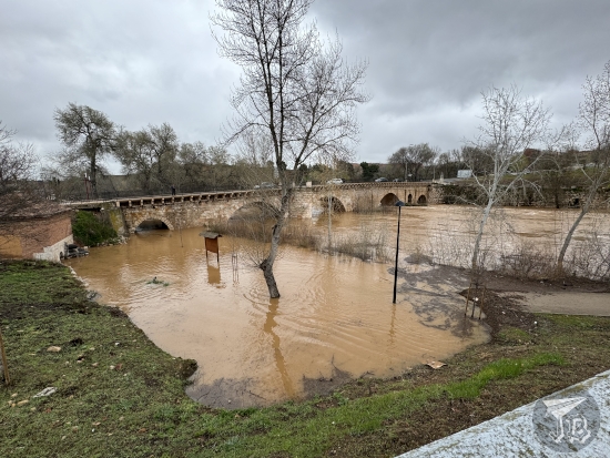
Guadalajara was built on the river Río Henares a tributary of a tributary of river Tagus. The Henares sprouts out of the mountain range Sierra Minsitra and runs about 160 km with a variable average flow between 10 and 40 cubic metres per second. The flow of the river and its tributaries is heavily regulated by the presence of a network of reservoirs in the area, designed to fight the cyclical droughts in central Spain, an arid plateau known as La Meseta (The Plateau). There are sixteen reservoirs in the province of Guadalajara, ten of them actively monitored. In March 2025, it rained so much that six of them (Alcorlo, Atance, Beleña, El Vado, La Tajera and Pálmaces) reached critical capacity and their floodgates had to be open, which dumped more water into the already “fattened” river. Furthermore, it was already thawing season, and the little snow that was on the peaks had started melting…
The result? The flow was up to over 300 cubic metres per second. That… is a lot. Official sources say that the water level increased by 40 cm, which of course caused the river to jump its usual banks. Along Guadalajara, this was mostly seen around the 10th century bridge Puente Califal (though other rivers were scary to cross). The structure was originally an Arab bridge, probably dating to the times of Abd al-Rahman III (Abd al-Rahmán ibn Muhámmad [عبد الرحمن بن محمد], 891 – 961 CE), though it was repeatedly damaged and repaired later on, particularly during the reign of Carlos III in the 18th century.
The bridge was built in ashlar masonry using a common technique from Al-Andalus architecture, stretcher and header soga y tizón, which means laying a layer of ashlar so the long side is outwards, then a layer so the short side is outwards, with the widest area always horizontal. The structure is almost 120 metres long, with five arches and four pillars, so thick that one of them allows for a spillway. Normally, only three of these arches are above water, allowing for most of the arch to be seen. This is a 2021 photograph which shows the usual situation underneath the bridge.

The humble bridge became the city’s most important tourist attraction during the storms period, as the river swelled and the water rose. Since I was in the area for work, I decided that I had to take a look. It was impressive. The water roared, and it had jumped the banks around the “park” area that has been built, along the footpaths.