1st January 2022: Barranco de la Hoz & some towns around (Spain)

I found myself socially free on the first so I decided to kick off the year by improvising a hike – and when I arrived at the parking lot I realised I was crazy person #3 to have the same plan. To be honest I kind of went along the flow for half of the day trip, with just a faint idea of what to do.

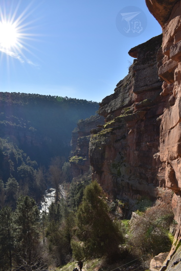
My first stop was an area in the natural park Parque Natural del Alto Tajo. One of the tributaries, the River Gallo, has eroded a deep valley in the sandstone and calcareous rockbed – Barranco de la Hoz, which translates to something akin to “Gorge Ravine” (though technically it could also be “Sickle Ravine”). The gorge is located in the north of the province of Guadalajara. Two hundred million years ago (Early Triassic period), the area was covered by the same sea that gave way to all the fossils that can be found in Albarracín and reached the muddy areas where dinosaurs left their footprints in Enciso.

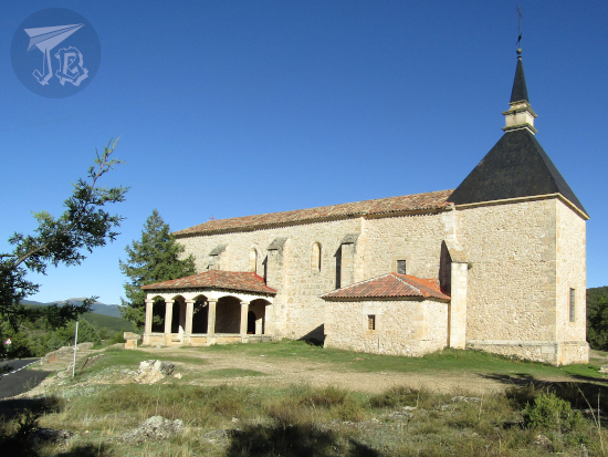
When the sea level receded, it left behind different layers of rock, that have been painstakingly excavated by the river Río Gallo for the last two million years or so (Quaternary period). There are conglomerates at the very base of the gorge, and red sandstone, calcite and dolomite in the upper parts. The vertical wall is around 115 metres high. At the base there is also a small hermit church. According to the legend, during the Middle Ages, the Virgin Mary appeared to one of the shepherds in the area – that is the reason why the area is also called Barranco de la Virgen de la Hoz. Next to the sanctuary there is a restaurant / hotel, and a parking lot. Along the river bank there are several tables for picnics and so.

Being the insomniac I am, waking up after the New Year celebration was not excessively hard. As mentioned though, as I was not sure I would be free until the previous evening, I just went along the flow of the day. I drove off and reached the gorge at around 11:00. The the car measured a temperature of -1 ºC. I was wearing five layers anyway so I was all right. Just before reaching the parking area, I had to yield to a sounder of wild boars.

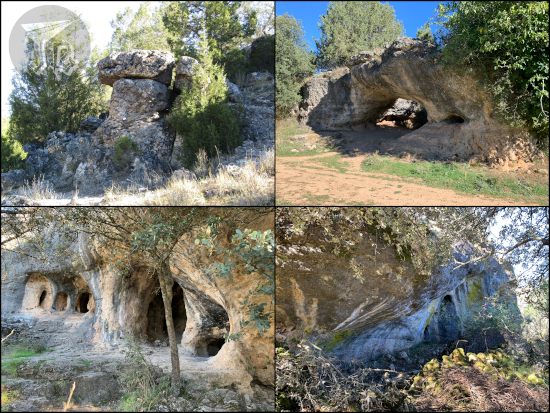
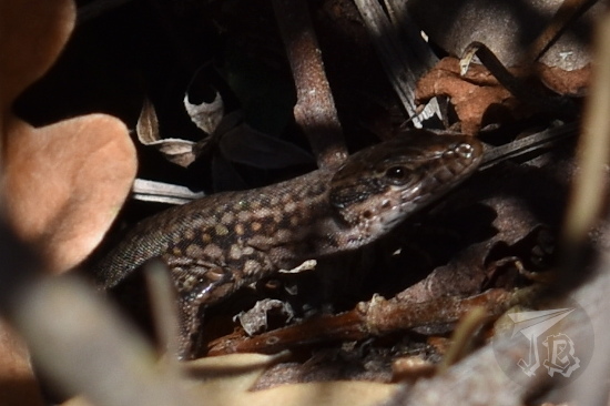
The sanctuary is the starting point of a path of around 400 steps carved and sculpted onto the vertical wall, ascending over 110 metres. The climb was not as hard as I expected, especially as the sun shone on the steps. I reached the mid-viewpoint in less than 15 minutes and sprawled on the stone ground for a little to bask in the sun. As I continued upwards, I encountered a small lizard doing the same sun-basking routine – Iberian wall lizard Podarcis hispanicus (maybe?). I finally reached the top of the gorge and I was the first on the upper viewpoint area for a while. Throughout the hike up, the strata can be clearly seen, along with fossilised ripples, fracture lines and the hints of some folds. The steps and viewpoints are protected by markers and verandas (helpful at points).

Halfway up a reddish sandstone wall. The picture faces the rising sun, and at the bottom of the ravine is the river, with the evergreen trees around.

Close up of a lizard hidden amonng leaves

Although you are technically supposed to stay on the trail, I honestly wanted to explore the upper edge of the gorge, so I went towards the rocky cliffs to the east. I came across marks caused by of boars, and European wildcat (Felis silvestris) paw prints, I also saw some birds of prey (very maybe a golden eagle, Aquila chrysaetos) , but not the right time to see much fauna – probably because around noon people started arriving with dogs. Also, it was stupidly warm for a first of January… Good thing I was using the good-old technique of having a lot of layers and shedding / putting them on as I felt warmer or colder.

A panoramic view of a rabine, with the river at the bottom.

A panoramic view of the top of a ravine, with the cut-off walls dropping from sight

A view of the vertical sandstone walls that create the ravine

A flying bird of prey and some animal tracks: a paw print and removed ground from a boar digging for acorns.

After an hour or so, I made my way downwards and I visited the church now that it was empty and walked into the area where the legend says the Virgin appared.

A hermit church built against / into the vertical wall of the ravine

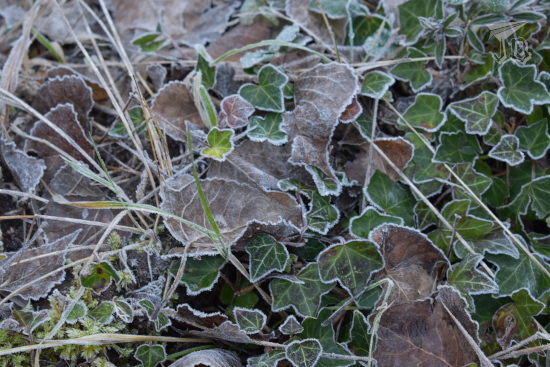
Then I walked around the river bed for a while. The river bank was covered in frosted leaves, and the water was quite cold. I layered up again…

The wall of the ravine from the riverbank

Ivy and fallen leaves on the ground. The rims are white with frost and ice

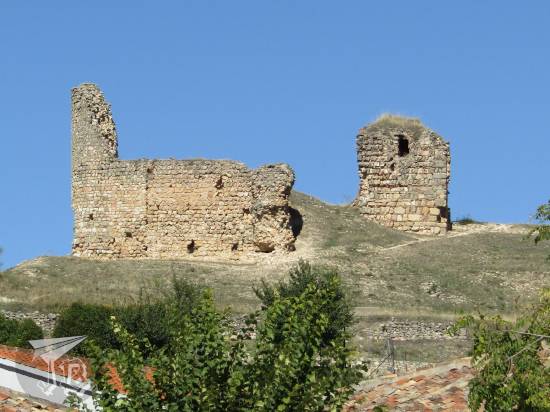
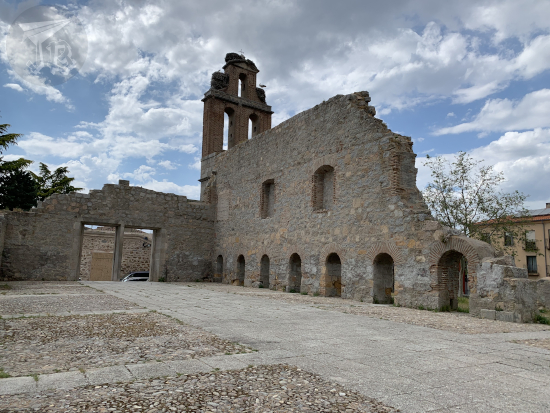
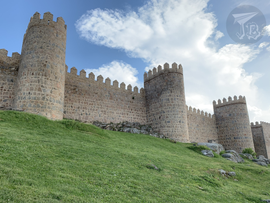
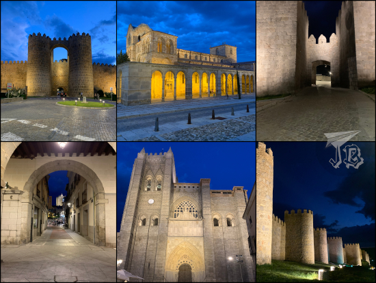
At around 13:15 I decided to head over to Molina de Aragón. It was New Year’s Day, so I did not expect anything to be open, so I just wanted to wander round for a while. Though the town is considered one of the coldest places in the area, when I parked it was warm. I found the castle Castillo de Molina and wandered around for a bit. The castle has three distinctive parts – the walled fortress, the lone watchtower Torre de Aragón, and the back area, which was cordoned off, but not walled, Prao de los Judíos. The first Arab castle or alcázar was built the 10th century, over an older Celtiberian hill fort. In the 12th century, it was conquered by the Christians and rebuilt in the Romanesque style. Out of the eight towers that the castle had, four of them have survived, along the ruins of two more.

A rectangular castle with quite a few towers and battlements on top. Around half of it is reconstructed, the rest is in ruins

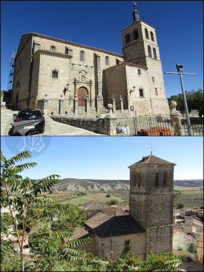
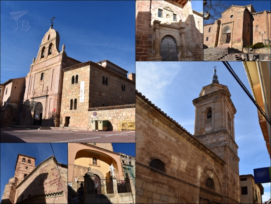
Afterwards, I took a stroll down the town. There are many churches dating to the Medieval times, most of them Romanesque style, some already showing hints of Gothic: Parroquia de San Felipe, Iglesia de Santa Clara, Iglesia de San Pedro, Iglesia de San Martín, Iglesia de Santa María la Mayor de San Gil. There were also some mansions and palaces.

Buildings in Molina. They all look reddish due to the characteristic rocks used to build them

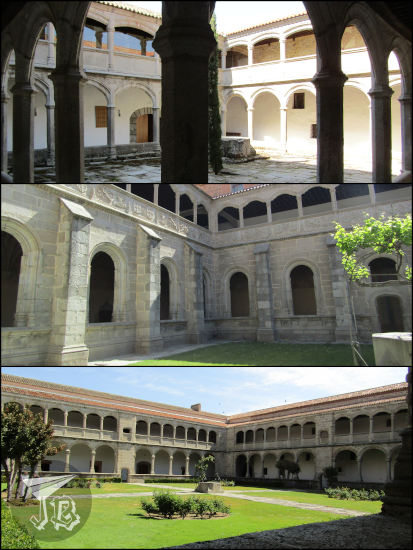
I tried to locate a bridge I had seen trying to find a parking spot, and it only took a couple of wrong turns to do so. The bridge is Puente Viejo, the old Romanesque bridge, built in the reddish calcites that are characteristic of the area. From there I also peeked onto Monasterio de San Francisco, originally from the 13th Century, though the current building dates from the 18th century.

A reddish stone bridge over the river. It has three arches, but today only the left arch is over the river, the other two are over grass.

A church with an angel on top of the belltower

It was already late afternoon, and I had a couple of options. In the end I decided to head back in order not to drive through the sunset – at this time of the year, the sun’s glare would hit me square in the eyes in the highway. However, on my way towards the gorge, I had driven through a tiny village, Rillo de Gallo, where, for some reason, there is a Modernist-style house, called, more or less formally, El Capricho Rillano (The Folly in Rillo), as a lot of Modernist buildings have the “whim” name in them. It was apparently erected by a builder who apparently liked the aesthetics, without an architect being involved. It was… interesting, though the village was tiny and it was difficult to get into it and find a place to leave the car without blocking a street.

Bizarre modernist house. The construction looks wavy, with snakes and twisted columns. The balcony is held out by gigantic hands.

That was the whole day in the end, I drove back home, and did not have much trouble with sunset. As a whole, I drove around 300 km, and walked just a little over 10 km. And it was way warmer than expected for a first of January! Here’s to hoping that it was a promising start to 2022…

8th October 2021: Tamajón & Cogolludo (Spain)

When I went to the waterfalls of the Aljibe I drove past a little village I had never heard of before – Tamajón, and a side sign reading “Pequeña Ciudad Encantada de Tamajón”. The term “Cuidad Encantada”, meaning Enchanted or Magic City, is used in Spanish to refer to karst formations. Karst is the name of a particular topography, created by the dissolution and chemical weathering of soluble rocks, chiefly but not just limestone.

The particular Spanish karst landscapes were formed by precipitation of salts – calcium carbonate – in the quiet waters of the Tethys Ocean during the Mesozoic Era (251-66 million years ago). Plate tectonics made central Spanish arise during the Cretaceous (the later subdivision of the Mesozoic, 140-66 million years ago) emerge, and the calcium carbonate became exposed to the elements, which started the erosion process. The most famous karst landscape in Spain is the Ciudad Encantada near Cuenca, which I guess spread the name.

Tamajón has a short hiking route around its karst formation, and while it is true that they are on the relatively smaller size, there are different shapes. I started my hiking route at the Ermita de la Virgen de los Enebrales, hermitage church dedicated to the Virgin of the Juniper Forest – the current building was reformed in the Renaissance style, thought the actual dates are shaky.

I started on the hiking route from the hermitage, along the road, and there were no markings there, so I kind of winged it for a while. After I took the first turn and started going up the rocks, I found the painting marking the routes – I had a handmade map because someone had shared it online, so I just went along it, and when I finished I redid about a fourth of it to take a detour to the other side of the road. There are cracks, arches, caves, cavities and capricious forms. I spent about an hour and a half walking around almost completely alone, which was awesome.

On my way back I stopped by the Church of the Assumption Iglesia de la Asunción, also a Romanesque – Renaissance mixture. The porch is typical of Romanesque churches in the Camino de Santiago (St. James’ Way), to shelter pilgrims.

As it was still early and I was relatively close, instead of driving home I headed off to another village called Cogolludo. I parked the car at the edge of the village and walked towards the main square, where there is a famous Renaissance palace Palacio de los Duques de Medinaceli. It is considered the first Renaissance Palace built in Spain, and it is reported to have been finished in 1492. The palace was designed by Lorenzo Vázquez de Segovia, with exquisite decoration, and the blaring lack of towers, which were very popular at the time. If I’m ever in the area again I might want to try to see the interior, which is only open in the guided visits.

The Palace stands in the main square Plaza Mayor which has a typical Castilian arcade with stone columns (unfortunately workers, sun and cars made it hard to take a good picture of it).

Cogolludo has two churches, Iglesia de Santa María de los Remedios (Our Lady of Remedies) and Iglesia de San Pedro (Saint Peter), both dating from the 16th century, but both completely closed down.

Finally, there are also the ruins of the Medieval Castle Castillo de Cogolludo, but there was not much incentive to climb up. All in all, it was a short but interesting morning – though I glad I teamed the two visits up, going to Cogolludo on its own would have not felt productive.

Driven distance: around 115 km
Walking distance: 7.27 km

29th & 30th May 2021: The Walls (and churches) of Ávila (Spain)

There was a little-talked about consequence of the Industrial Revolution in Spain. While it is widely known that it drew a large number of people to the cities and towns, few stop to think of the subsequent steps that had to be adopted. More people in town required housing, and thus a number of projects denominated ensanches or “widenings” were projected and carried out. Even though such a thing makes sense, here lies the problem – in order to enlarge the urban area, many Spanish cities and towns tore down their Roman and Medieval walls, leaving either bare traces or nothing at all.

Legend has it that the town of Ávila lacked the money to demolish the wall. In retrospect, that was a good thing, because today, the walls that surround Ávila, Murallas de Ávila are among the most impressive Europe, some say that even better preserved than Carcassonne (France).

Ávila is a couple of hours away by car, so we drove off on Saturday morning at around 8 am and were there just before 10 am. We entered the city through one of the city wall gates, Puerta del Carmen.

Approach to the walls

We parked (100% ditched the car) at the hotel and checked in – even if it was quite early, they told us that one of the rooms was already prepared and gave us the keys. Unfortunately, it was not, and since the blunder was a Covid-protcol blunder, they upgraded us as an apology. The hotel, Parador de Ávila, belongs to the Spanish network of Paradores, and it is located in a 16th century palace, Palacio de Piedras Albas. We booked late-check-out for the following day, which can be done “for free” booking lunch in the restaurant (which is obviously not free).

Parador

Our first stop was the tourist office, but not the one that is clearly signalled in the middle of the town – the one that is located outside the wall and you have to turn around and around to find. But we needed it to buy the 48-hour pass to the monuments. Then we stuck around to wait for the nearby church to open, which gave way to observing the wall for the first time.

The Muralla de Ávila has been a Unesco World Heritage site since 1985. The structure is clearly defensive and it was built towards the end of the 11th century, quite probably as extension or reinforcement of a previous one, either Roman or Arab – though the Roman theory is the most credible as some pieces used in the original wall seem to come from a now-lost Roman cemetery, and there are documents about a Roman camp with similar shape. The wall has been restored in several occasions, and after surviving the ensanche risk, it was declared national monument and cleared of attached houses. Today most of the wall belongs to the Spanish government, and it is managed by the town hall, though there are some private parts, such as the ones that are part of the cathedral. The walls close off all the historical centre. They have a perimeter of 2,515 metres, with around 2,500 merlons, almost 90 turrets, and nine gates. Our second gate was Puerta de San Vicente.

Puerta de San Vicente

The first monument we stopped by, as soon as it opened since we were already there, was the basilica church Basílica de San Vicente (officially Basílica de los Santos Hermanos Mártires, Vicente, Sabina y Cristeta, three Christian siblings who were martyred nearby). It is one of the most important Romanesque buildings in the whole country, built between the 12th and the 14th century. It is protected as part of the World Heritage Site declaration. One of its characteristics is the golden rock in which it is built – sandstone-looking granite.

Iglesia de San Vicente

The inside of the basilica is, in the typical way, a mix of more modern styles. The grave of the martyr siblings is Pre-gothic, and the large altarpiece is Baroque. In the crypt there are proto-Christian pieces and a Romanesque Virgin which we did not get to see and which is the patron of the town.

Iglesia de San Vicente

Afterwards we headed off to the cathedral Catedral de Cristo Salvador, which is considered the first gothic cathedral in Spain (something that other people say about Cuenca), with clear French influences. It was designed as a fortress church as its abse dubs as one of the turrets of the city wall.

Catedral de Cristo Salvador

In later years, a choir was added, along with a Baroque altarpiece. The walls are also sandstone-looking granite, but some elements inside are limestone and wood.

Catedral de Cristo Salvador

To the side of the cathedral stands the cloister, which holds the grave to the first modern president of Spain, Adolfo Suárez, and the entrance to the cathedral’s museum. It yields to views of the tower and… the storks that squat there.

We headed off towards the Museum of Ávila. First we stopped at the former church Iglesia de Santo Tomé, which today is a warehouse for the museum, but can be visited anyway. When I was young, I studied the statues / sculptures called verracos, built around the 5th century BCE by the Vettones, a Celtic pre-Roman civilisation that faded upon the arrival of the Romans. The verracos are crude statues that represent four-legged animals – bulls, boars or pigs. At the time, I had only heard about a number of them, and was somehow under the impression that there were two or three around. I was quite wrong, apparently they pop up from the snow like daisies or something. In the church-turned-warehouse there were like twenty, one outside, there was one at the hotel garden… so no, apparently they are quite common. Other artefacts in the building include some carriages, Roman sculptures and mosaic, Muslim funerary artefacts and roof boards…

Iglesia de Santo Tomé

Then we moved onto the museum itself, Museo de Ávila, with a beautiful patio and a number of archaeological and ethnological items which represent the history and folklore of the town.

Museo de Ávila

It was almost time for lunch, so we headed off towards the restaurant where we had booked. Before, we made a small stop at an old palace Palacio del Rey Niño, built in the 12th century, today turned into the Post office and the public library, with a patio closed off by the Walls themselves.

Palacio del Rey Niño

Then we walked by the modern marketplace.

mercado

Which happened to be right in front of the restaurant, named La Lumbre. Aside from its walls, Ávila is famous for its cattle, a particular breed called Raza Avileña – Negra Ibérica, and of course the meat the animals produce, especially the matured and grilled meat from older oxen. After the animal has been sacrificed, the meat is matured in a traditional process called “dry maturation” for six weeks before it is grilled. We ordered the rib steak, chuletón to share, along with some grilled vegetables, a “tomato salad” that was a… one-tomato with dressing. And then there were desserts, aside from chocolate cake, we ordered yemas de Ávila – a typical confectionery made with egg yolks, lemon juice, cinnamon, and caster sugar. Lots of typical stuff, as you can see!

lunch

Our next stop was the main square, called “little market square”, Plaza del Mercado Chico, along with the town hall or Ayuntamiento. The square was rebuilt in the 19th century and is flanked by arcades. The town hall was built in 1862.

Plaza del Mercado Chico

Plaza del Mercado Chico: Ayuntamiento

After a brief stop at the Parador for some rest, we headed off to find a convent / monastery on the other side of town. On the way we came across some ruins that I assume are the church Iglesia de San Jerónimo, as they sit in the square of the same name.

Ruinas de San Jerónimo

We reached the convent Convento de San José, a reconstruction of a previous monastery and church, the first founded by Santa Teresa de Jesús (Saint Teresa of Ávila), a Christian “doctor of the church” and mystic Carmelite nun, known for her ‘raptures’, her reforms, and her literature work. More on her later though. The convent and church were a little… underwhelming, even if is a World Heritage building.

Contento de San José

Then we walked back towards the historical centre, and walked past the church Iglesia de San Pedro, a 13th-century building with a great rose window, but which was closed (reforms).

Iglesia de San Pedro

On the other side of the square, Plaza del Mercado Grande (Big Market Square) stands another of the wall gates, Puerta del Alcázar, and a monument to Saint Teresa Monumento a Santa Teresa: La Palomilla.

Puerta del Alcázar

Next we separated and I went off to climb the walls Murallas de Ávila. Well, to walk on the parapet. Due to Covid, there is only one access, next to the Cathedral and its gate Puerta de la Catedral. The walkable area is around 1.4 km, including walking over some of the gates and up and down more than a few turrets. It allows for some amazing views of the town and its outskirts…

Views from the walls

… but also of the wall itself, both the original walls and the add-ons from later eras (and a magpie).

When I reached the end of the walk, I went down and crossed the bridge gate Puerta del Puente, named that way because it overlooks the bridge over the Adaja river. I could not take a picture of it because the traffic police was checking cars at the roundabout in front of the gate. Thus, I headed off to the pedestrian bridge to cross over towards the tiny hermit popularly known as “the four posts”, Los Cuatro Postes, which yield to an impressive view of the town and its walls.

Cuatro Postes

Views on the wall

Avila and View

I walked back to see the walls from the base. Then I crossed the gate we had driven through in the morning, Puerta del Carmen, and I headed back to the hotel for a drink.

At the feet of the walls

Puerta del Carmen

After a while we headed off for dinner and tried another of the typical dishes in Ávila, patatas revolconas – mashed potatoes with paprika and pork rashers, and waited for the sun to go down so the city lit up.

Patatas revolconas

A walk around the town yielded to views of the Iglesia de San Vicente and Puerta de San Vicente, some of the inner streets leading to the town hall Ayuntamiento, the longer area of the Muralla and the Puerta del Carmen.

Night view

And then I had a very, very long shower and went to bed.

In the morning, breakfast was had – not a fan of the “we can’t have a buffet so we prepared this and this is what you get” plate, but whatever. I mentioned Santa Teresa before, let’s get into that a bit further. She was a 16th-century nun born near Ávila, canonized in the 17th century, and elevated to doctor of the church in the 20th century. She is conisdered one of the great mystics and religious women in the Roman Catholic church, author of a number of spiritual classics, and the reformer of the Carmelite nun order into the Discalced Carmelites. She founded convents all over Spain and was known for her mystics raptures which may have been messages from God or epileptic attacks. She is one of Ávila’s most important historical figures and wherever you go there are traces of her. In the place where her house stood now there is a convent, a church, a reliquary room and an interpretation museum, with really strange hours on Sundays. We could see the convent / church Convento de Santa Teresa de Jesús / Iglesia de la Santa and the reliquary room where no pictures were allowed Sala de Reliquias between services.

Iglesia de la Santa

On the way, however, I found some interesting ruins – the gate to the former hospital Hospital de Santa Escolástica, and we walked past a bunch of palaces.

Portada de Santa Eulalia

Then we moved onto a long walk to the 16th- century Gothic monastery Real Monasterio de Santo Tomás, which we could see due to lucky timing as there was a First Holy Communion Mass happening and the local little old ladies were not to keen on cultural visits of the church.

The monastery has a church, three cloisters and two adjacent museums. The church has an impressive Gothic altarpiece (by Pedro Berrugete, one of the key painters riding the wave between Gothic and Renaissance arts), and hosts the grave to the Catholic Monarch’s only male son.

Santo Tomás

The three cloisters: Claustro del Noviciado, Claustro del Silencio, and Claustro de los Reyes Católicos (Novitiate, Silence and Catholic Monarchs).

Santo Tomás Cloisters

The Museum of Natural Sciences Museo de Ciencias Naturales, an occupational therapy project could… be better, and sets the expectation bar rather low for the next one.

Museo de Ciencias Naturales

However, the Museum of Eastern Arts Museo de Arte Oriental is pretty impressive. It contains pieces and artefacts that the Dominican missioners brought from China, Japan, Vietnam and the Philippines.

Museo de Arte Oriental

And in the end, that was it for the weekend. We walked back, decided to give the museum of Saint Teresa a miss, had a drink, had lunch and went back on our merry way – with a a view of the train tracks over the dam of the reservoir Embalse de Fuentes Claras.

Train tracks over Embalse de Fuentes Claras

Walked distance (Saturday): around 12.5 km
Walked distance (Sunday): around 6 km
Total distance driven (both days): around 340 km

26th March 2018: Dinosaur bones and Lover mummies {Dinosaurs in Teruel, 2018}

We got to Dinópolis so we could be there when they opened in hopes to ditch the families-with-kids crowds, but to our confusion, we were told that even if the park was open, the palaeontology museum would not be for another hour. Furthermore, the only option to see the museum was with a guided tour. We did not care much about the 3D cinema, but there was literally nothing else we could do until they opened the museum part. We spent the morning in the park. We had to watch the first film, and somehow ended up doing two rides (Viaje en el tiempo & Último Minuto) and a show (the T-rex one), but the big things we cared about were the museum and the so called “Tierra Magna”, where the 1:1 reproduction stand.

The museum has a direct view to the lab, and while it has very few original and unique exhibits, is really good and informative. The big problem was, in my opinion, that it was only guided-access and those stress me out. Why can’t I just roam to my heart’s content and have to listen to a poorly-trained guide? We somehow managed to ditch the tour when the second and third groups came in and a bunch of people mingled around.

A collage showing different fossils and replicas from Dinopolis

It was cold outside, so we only had a quick stroll around “Tierra Magna”. We had lunch and decided we were done. If I had to rate this, I’d say it is a decent palaeontology museum with a lot of kid-friendly stuff around it – the latter is completely skippable, too, but I guess it brings money.

Life-size reproductions of dinosaurs outside Dinópolis Teruel

In the afternoon we headed off to see the cathedral, Cathedral of Santa María de Mediavilla, but I did not manage to sneak a picture of the famous wooden ceilings.

Outside view of the Cathedral

Later, we had a reservation to see the Complex of the Lovers of Teruel, which included the Iglesia de San Pedro (Church of St. Peter), its cloister, and the gardens.

Nave in Saint Peter church

Cloister in Saint Peter Church

Finally we got to the Mausoleum, el Mausoleo de los Amantes. The story tells that she was a rich heiress and he was a poor man, so he left to gain riches. While he was away, she was given off to another man and married, and when he came back she could not be with him because she was loyal to her husband. He died of a broken heart after she refused him a kiss, and she died after kissing his dead body. The bodies of the lovers were buried together afterwards. The two mummified bodies were found in the church of St. Peter, and they were thought to be the lovers, so the tombs were sculpted – if you crouch, which by the way I didn’t, you can see the mummies through the marble. The tombs were designed so that the lovers’ hands are very close, but they don’t really touch, albeit their shadows superimpose, as if they did.

Mausoleum of the lovers - they lie next to each other, hands reaching for the other one, but only the shadows touch

After this, we walked around town for a while and found the third tower, the Torre del Salvador.

Salvador Tower

We finished the tourist day at the monumental Escalinata de Teruel (the Grand Staircase).

Monumental Staircase

As we walked back to the hotel, we saw a beautiful sunset.

Golden sunset