12th & 13th November 2022: Santiago de Compostela (Spain)

Here’s a little secret – people don’t like flying on the 13th, even less when it’s a Tuesday. Thus, I came across a bunch of awesome offers for the 13th of December, which unfortunately I could not take up due to work uncertainties. What I could muster was a mini getaway on the weekend of the 12th/13th of November, to the northern Spanish town of Santiago de Compostela. There were a few reasons for this choice – one, cheap flights; two, I’ve recently started considering a route through the so-called Camino de Santiago (St. James’ Way); and three, pandemic shuffled ‘Holy Years’ round so there was a special gate to the cathedral open that I wanted to see. I flew out around noon on Saturday and came back on Sunday night. It was a perfect plan for a decompressing getaway.

Santiago de Compostela is known as one of the most important pilgrimage cities in the world. According to the Christian tradition, the tomb of Apostle James was found in the area in Middle Ages (different sources vary throughout the 9th and 11th century), and the pilgrimage to visit the remains became one of the most important in the Christian faith, alongside Rome and Jerusalem, to the point that the pavement proudly states that “Europe was built on the pilgrimage to Santiago”. While I’m not religious, I have a thing for religious architecture, and as mentioned above I’ve been thinking about the Camino for a while, and visiting the goal felt a good way to start organising how I wanted to look at things.

However, let’s say it wasn’t the most perfect getaway ever. Though the flight was on time, and pretty short, there was turbulence – not something too out of the ordinary, but here’s something you might not know about me. Back in the mid-nineties, I sort of crash-landed in the Santiago airport, so let’s say I was not so invested in a bumpy flight.

As the flight had been very cheap (about 30€), I had decided to splurge a little in the hotel – and I found a not-so-bad offer of half-board at the Parador de Santiago – Hostal Reyes Católicos, downright at the centre of the city. It is located in the old pilgrim hospital, and it is a magnificent building, aside from a five-star hotel. I arrived around 14:00, and the room was not ready – fair enough. I wanted to get there early in order to drop off my luggage, and make sure I could arrange my dinner reservations for a convenient time. One of the reasons I decided to book half-board in the Parador was to guarantee myself a meal late in the evening, as I had booked a walking tour at 20:00, and the main restaurant served dinner till 22:45.

Wide shot of the Parador. It shows a severe building with an ornate gate. The sky is bright blue.

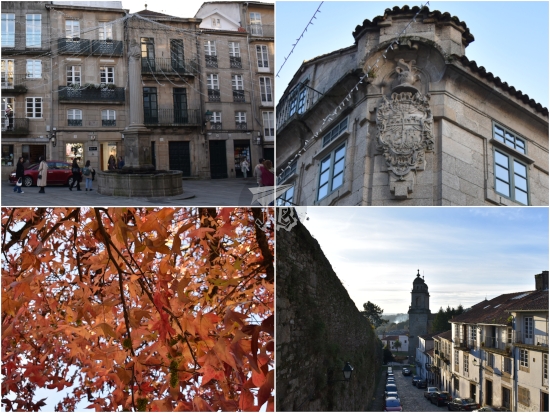
Unfortunately, the check-in staff “had booked me” at 20:30, and they asked if that was okay. I replied it wasn’t, and explained the reason stated above – the staff then said that they could accommodate me at 22:00 at the secondary restaurant, but not at the main one. I answered that then I’d have dinner at 22:00 at the secondary restaurant then, but the staff asked me to check the menu. I stated that it did not matter. I needed my dinner to be at 22:00, and if the main restaurant wasn’t available, it would have to be at the secondary one. The staff asked me to check the menus, and I explained again that I had a tour from 20:00 to 21:30 – I needed dinner at 22:00. I thought that was resolved, and as it was too early to get a room, I picked up my camera, left my backpack in the locker room, and went on my merry way to explore the outdoor “monumental route” within the historical city Ruta Monumental de Intramuros. The old city of Santiago is part of the Unesco Heritage Site Routes of Santiago de Compostela: Camino Francés and Routes of Northern Spain Caminos de Santiago de Compostela: Camino francés y Caminos del Norte de España.

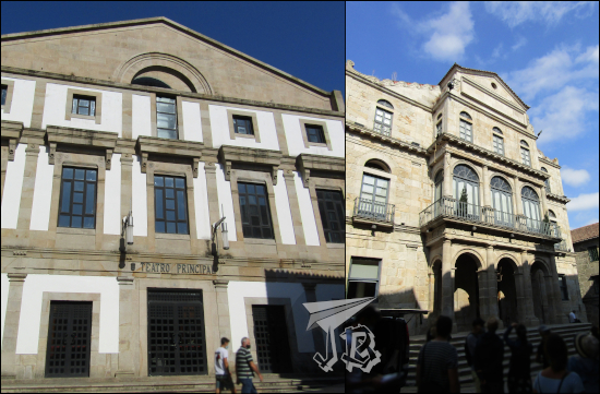
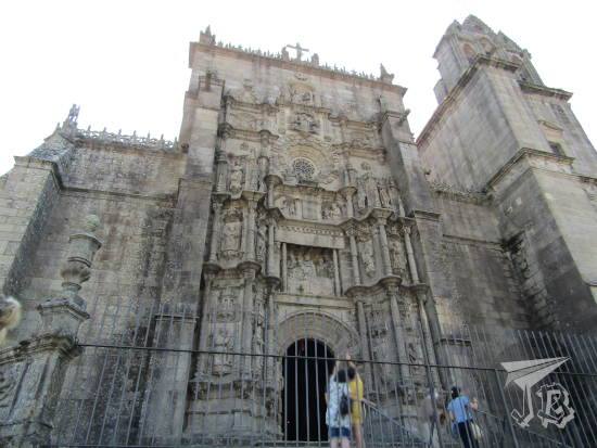
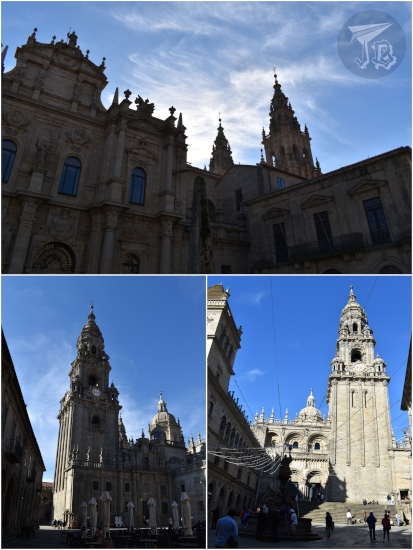
As I had tickets for different activities in the cathedral booked for the previous morning, and the Sunday forecast was rain, I decided to do most of the walking on my first afternoon. I started off in front of the cathedral façade in the square Praza do Obradoiro (the Artisans Square), which hosts the town hall in the former Neoclassical palace Pazo de Raxoi, the Parador itself, and the main – but closed, will get into that later – entrance to the cathedral Santa Apostólica y Metropolitana Iglesia Catedral de Santiago de Compostela, with its Baroque façade called Fachada del Obradoiro.

Baroque façade: two towers and twin set of stairs, fenced away.

I walked around the cathedral, and stopped at all the other squares: Praza da Acibecharía (the Black Amber Workers Square), Praza da Quintana de Vivos (Living Villa of the Living Square) and Praza das Praterías (the Silversmiths Square).

A collage of views of the cathedral of Santiago.

I walked down Rua do Villar, which is the closest to a main street the historical town has. I strolled around the historical centre – there are many interesting buildings and churches, alongside the market. At some point I entered a bakery, but I kinda ran away when I heard the prices they were charging.

Santiago Route.  An archade, a fountain, an ornate corner with a coat of arms carved into it.

After an hour and a half or so, I found the convent-turned-museum Igrexa e Convento de San Domingos de Bonaval that has become the ethnological museum of the Galician people Museo do Pobo Galego. The museum itself was not too spectacular, but the building itself was fantastic. One of the most amazing things was the triple-helix staircase that joins the different floors on one side, and the remains of the gothic church (where I got to climb the pulpit). To the side there’s the pantheon for illustrious Galicians, including one of the few female historical figures in Spain – poet Rosalía de Castro.

Monastery and museum. The pieces include a humanoid stone idol, some Christian figures in polychromated wood, and two pipes

View of the triple staircase, from above, from below and through the door from one of the sides.

A view of a gothic chapel, showing an empty altar.

This was around 16:30, and even if I was not even a bit hungry, my legs shook a little. Thus, I decided that I needed to find a supermarket to buy a snack – I only had coffee before I left for the airport at 9:00. Before getting to the supermarket though, I walked around the former orchard and graveyard of the convent, now a picnic-friendly park Parque de San Domingos de Bonaval, full of ruins and fountains.

The previous church, from outside, on the right. There's a winter tree in front, and some old niches on the left wall.

I grabbed my snack and went back to the monumental route until I was back at the Praza do Obradoiro. I walked around to see the sunset, and caught a glimpse of the light playing on the façade of the church Igrexa de San Frutuoso, and some nice views from the adjacent park (which turned out to have been another graveyard) Xardín do Cemiterio de San Frutuoso.

Santiago sunset. Upper picture shows the church of Saint Fructuoso, and the lower one a view of the nearby park with the sun setting in the background

It was around 18:00 at that time, so I could finally check in – which I did, only to find out that the staff I had talked to had decided not to book my dinner in the end, which lead to me needing to explain about my tour again to a new staff who told me they couldn’t book me at 22:00 on the secondary restaurant! It had to be at 21:45, but they could notify the restaurant that I would arrive a bit later. I was really not impressed by the whole thing, even less when I apparently needed a bellboy to guide me to my room and carry my backpack– and of course get tipped.

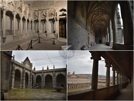
I had my snack and then went on to explore the building. As I did, the sun completely set, so the different lights were cool. The Hostal Reyes Católicos used to be the pilgrims’ hospital. It is a huge rectangle with four interior cloisters named after the four Christian Evangelists, the inner areas having been refurbished into the rooms.

The four gothic cloisters of the Parador. Two have some greenery on them, the other two are just grey and built.

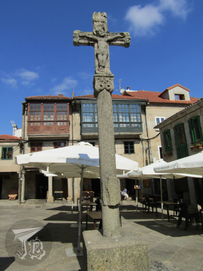
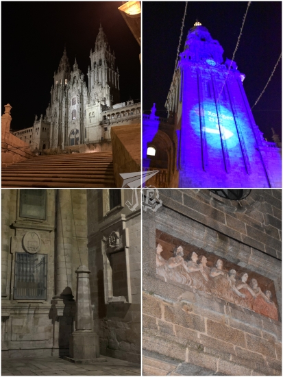
A few minutes before 20:00, I left for my tour. Although I’m not a big fan of tours and group activities, I had had my curiosity piqued by a “theatrical visit” of the historical centre of the town called Meigas Fóra. In the area of Galicia, a meiga is a type of traditional witch, good or bad, depending on what side the person speaking about them is – in this case, the guide being a supposed-meiga, of course they were all neat and nice. The tour was supposed to tell about the different legends and interesting supernatural trivia of the town, but just ended up being a bit watered-down walk around those graveyards-turned-parks I had walked before. The coolest thing was finding the pilgrim’s shadow Sombra del Peregrino, a fun game of light-and-shadows in one of the squares around the cathedral.

A view of the cathedral of Santiago at night, illuminated, on top. On the bottom, a column casts a shadow onto the wall behind it - it seems to be that of a man with a walking cane and a travel hat.

Hilariously though, as we were walking, someone approached me to ask in wonder if on top of taking the tour alone, I was in Santiago all by myself, in total awe of someone travelling on their own. She said that she would never be able to do so – while she took selfies of herself because the people she was “touring” with could not be any less interested…

After the tour I went to have dinner – guess what? At 22:00 h! Let’s say that it was not the greatest experience. The restaurant staff had their hands full with a table of around 20 drunk “pilgrims” who had come all the way from South America and were rightfully celebrating – albeit loudly and a bit obnoxiously (all that pilgrim wine, no doubt) – that they had reached the end of the Way. The rest of the patrons were, including myself, four one-person tables, which made me wonder if they just don’t book one-person tables in the main restaurant after the first shift. The floor staff – basically one working waiter, and one wandering waiter – was overwhelmed by the table, and it took me over an hour to finish my dinner – which was some local octopus (pulpo a feira), a roasted great scallop (Pecten maximus, not only a delicious shellfish, also the symbol of the town and the related pilgrimage, called vieira in Spanish) and a piece of the typical almond pie (tarta de Santiago).

Dinner: pulpo, a scallop and a piece of cake.

Then I went to my room for a nice hot shower and to get some sleep. I was surprised then to find no extra blanket in the wardrobe, though there was an extra pillow. This was around midnight already so I decided not to hit reception for the extra blanket and just cranked up the air-con on and off to stay warm. I slept on and off, too, but it was not too much of a long night.

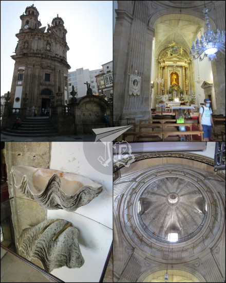
The next morning I had breakfast and set out for my day at the cathedral, Santa Apostólica y Metropolitana Iglesia Catedral de Santiago de Compostela. Santiago was built around the 7th century legend that the apostle James the Great, Santiago el Mayor, was buried in the area of Galicia, after having reached Spain to convert it into Christianity. In the 9th century, a tomb was discovered among some abandoned Roman ruins, and the local bishop had “the certainty” that it was the Apostle’s tomb. The bishop informed the King, who was the reported first pilgrim, and later ordered that a church should be built to commemorate the finding.

As the number of pilgrims grew, the church became too small, so subsequent temples were erected. The current interior was built between the 11th and the 13th century in a very pure Romanesque style, but the exterior was covered in the 18th century, in a very adorned Baroque style, which is also the style of the altar.

The most important piece of the cathedral is the Portico of Glory Pórtico de la Gloria, the Romanesque entrance to the 12th-century cathedral, with 200 sculptures carved in stone in the three-archway portal. The entrance now is locked away, you have to pay to see it, and photographs are not allowed.

For starters, I climbed up to the roof of the cathedral and the bell tower – not really the bell tower but the “rattle tower”, as the bells chime on the eastern tower, and the rattle is played on the darker, western tower. The roof was restored as recently as 2021, and from there there are some nice views of the town.

The towers of the cathedral from the room, and some aereal shots - one shows the Parador cloisters from above.

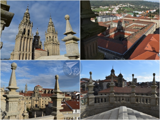
Between visits, I went inside the cathedral, where the pilgrims’ mass was about to start. I might have stayed out of curiosity had I been in town for a longer period. Then I visited the portico – since pictures were not allowed, I’ve rescued some 1995 ones from when I were in town as a teen.

Three shots of the  very baroque altar in Santiago - it is heavily decorated and painted gold. On the bottom right, a silver urn, also very ornated, supposedly where the remains of St. James are.

A collage showing several sculpures of the Portico of Glory - Romanesque statues richly coloured and decorated, they look placid

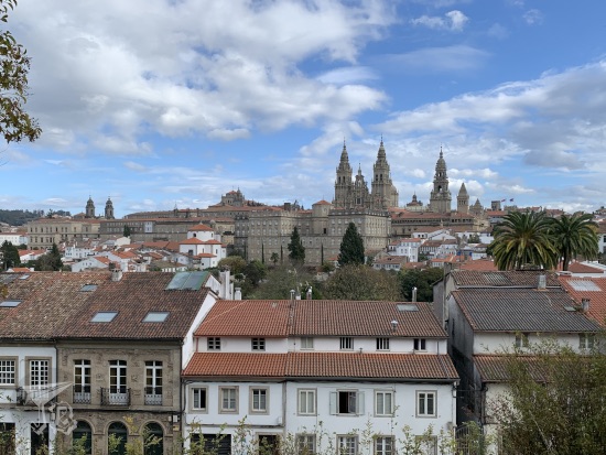
After wandering the cathedral for a bit longer, I made the most out of the last hour of sunshine to head to the park Parque da Alameda to find the spot Miradoiro da Catedral next to a huge centennial eucalyptus tree (Eucalyptus globulus labill) Eucalipto centenario, a 120-year-old specimen, considered one of the oldest eucalyptus trees that was planted in Europe after captain Cook “discovered” Australia and the species was introduced by Fray Rosendo Salvado.

A panoramic view of Santiago, showing the cathedral.

My next stop was the museum of pilgrimages and Santiago Museo de las Peregrinaciones y de Santiago, which was free due to the Covid recovery plan. It features a collection of items related to Saint James Way, and other important pilgrimages of the world, including the Japanese Kumano Kodo [熊野古道], and the Muslim Mecca Pilgrimage Ḥajj [حَجّ]. The upper floors are dedicated to the hagiography of Santiago / James through the Way and in the city.

Museum of Pilgrimages. A collage that shows a wooden statue of Santiago on a white horse, sword raised; other depictions of Santiago as pilgrim; some paper scallops decorated by kids; and a Japanese sacred gate.

Later, even though I should have gone to eat a bite, I headed to the monastery and museum Mosteiro de San Martiño Pinario, religious complex built between the 16th and 17th centuries, though the inner areas and chapels date from the 18th century. Today it’s a cultural centre, and alongside the church, it features a museum with block prints, fossils, an ancient pharmacy… The church has the most baroque Baroque altarpiece I’ve ever seen, and two choirs – one behind the altar, and the other one up on the second floor.

Exterior of the monastery, including the double downward staircase, and a picture of the interior, showing a very Baroque altar painted in gold.

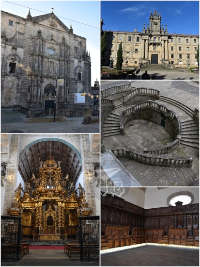
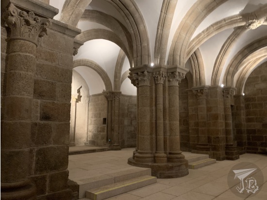
Finally, I stepped into the museum of the cathedral Museo de la Catedral de Santiago de Compostela, which features the entrance to the cloister, library, and the upper galleries, aside from artistic and religious treasures such as the original stone choir, wooden carvings, and tapestries. I was also able to access the upper galleries and look at the rain in the Praza do Obradoiro, and later the crypt.

A collage showing the cloister of the cathedral of Santiago while it rains outside, and the former Romanesque choir, carved in stone.

Romanesque arches and columns built in stone, and a cast ceiling.

After one last visit to the cathedral and its shop, I got myself a last souvenir – a silver and black amber bracelet I had seen upon arrival, and took a taxi back to the airport in order to fly back. All in all, I was not too impressed by the city nor its inhabitant, and I was pretty disappointed in the Parador. I think it has put me off the idea of doing the Camino as much as I thought I wanted to, but not every trip is perfect, I guess, and I hope my memories warm up with time.

A silver and black amber bracelet. The silver is very fine, and the gem is bright black.

Walking distance: around 11.68 km (18659 steps) on Saturday and 10.58 km (16931 steps) on Sunday, not counting airport transits

13th September 2022: Wadi Rum (and the bus) {Jordan, September 2022}

I had a boiled egg, potato hash-browns and coffee breakfast because my body was craving salt, I guess. Then we set off on the bus, where we ended up spending around seven hours (the 412 km are supposed to be done in 5 hours and a half, but that does not take into account bad traffic). Urgh. Our first stop was a viewpoint over the whole canyon area.

Wadi Musa valley panorama, showing the deep gorge from above

The second stop was a souvenir shop that had probably somehow bribed our guide or driver for it. None of us even bought anything, but we were forced to be there for about half an hour before we could continue to the only organised activity for the day – a two-hour jeep tour throughout the Natural Reserve and Unesco World Heritage Site of Wadi Rum | Wādī Ramm [وادي رم]. It is the largest wadi “valley”, created by alluvial fans and wind deposits, rather than the idea of a river bed. They are often found in deserts.

During the tour in Wadi Rum Reserve [محمية وادي رم] we drove through the desert and stopped at some rock formations that had built a gigantic dune. Wadi Rum used to be a granite and sandstone rocky formation. Thousands of years worth of wind eroded the sandstone back to sand, forming and shaping the desert dunes. Huge granite structures still stand, such as the Seven Pillars of Wisdom [عمدة الحكمة السبعة], just at the beginning of the route. One of the stops is the tourist-named Big Red Sand Dune, which you can climb for kicks, giggles and some nice views of the landscape.

Driving into Wadi Rum. The roof of the jeep is visible, along with a rock formation in the background. Between us and the rock formation there is the other jeep, causing a dust cloud

Back of a dune we had to climb, and the rock + sand landscape that could be seen from the top. Wind erosion marks have created soft ridges. The rocks are red-grey and the sand is rose-gold

Then we drove off to see some petroglyphs, and were offered dromedary rides. These petroglyphs, depicting early humans and their cattle – bovines and dromedaries – are the reason for the Heritage status.

A rock wall with some dromedaries in the foreground + a close up of the petroglyphs engraved in the rock, also showing dromedaries (by JBinnacle)

Finally we were shown a Bedouin tent at the feet of the Lawrence Canyon, a beautiful rock formation with faces of Jordan monarchs. Unfortunately, we did not get to see any onyx or fennec foxes, but I did see a small lizard. The Bedouins treated us to a cup of tea, but then we had to tip the driver about 10€…

Lawrence Canyon, a deep cut in the rock filled with sand at the bottom + details of engraved faces and Arab script, a lizard and a bit of tea, along with a traditional Bedouin coffee maker

Afterwards, we started off our trip back northwards back to Amman | ʻAmmān [عَمَّان]. Though the trip is supposed to take about 4 hours, it was way more than that, and we did not arrive at the hotel until way past 18:00. We went through the security checks and ended up learning that we could not travel between floors, so we could not go to the others’ rooms using the lifts, and the stairs were blocked… Well, at least we had… views?

A view of Amman skyline in the dark

After we managed to regroup, we had dinner and decided to try to check in online for the flight next day’s flight – and I was successful. Apparently, the airline only cared about us filling in our Covid certificate to enter Jordan, we were on our own for the way back.

12th September 2022: Petra {Jordan, September 2022}

Petra | Al-Batrāʾ [ٱلْبَتْرَاء] is without doubt the crown jewel of Jordan. It was the capital of the Nabataean Kingdom, and a strategic point in the middle of the trading routes. Nabataeans were one of the nomadic Bedouin tribes in the Arabian Desert that eventually settled and established the capital of their kingdom around the 2nd century BCE. Soon, Petra became a major trading hub and flourished as the Nabataeans were extremely skilful in harvesting rainwater and agriculture in the barren deserts. The Nabataeans also became very good at carving the sandstone of the canyon where they built their city. They lived in caves in the rock and created intricate façades in the sandstone of the mountains surrounding the site.

Eventually, water dried out and Petra fell, becoming a lost city, a tale told by crusaders when they returned home. In 1812, Swiss traveller Johann Ludwig Burckhardt “discovered” Petra for the Europeans, and excavations and archaeological expeditions took place throughout the 20th century. At this time, a Bedouin tribe, the Bidouls lived in the area, and in 1985 they were resettled in a nearby village built by the Jordan government before the site was designated a Unesco World Heritage Site.

As part of the concessions made for the Bidouls, they were given sole rights to the exploitation of the archaeological site, and their traditional customs were declared Unesco Intangible Cultural Heritage. Unfortunately, these traditions have devolved today into blatant child labour, peddling, and animal abuse. Barefoot children run after tourists to sell trinkets, women handle myriad of stands illegally selling rocks and fake archaeological artefacts along with imitation jewellery, cosmetics, decoration and so on, and men offer the services of thirsty and sad-looking donkeys, dromedaries and horses to move round the area. And while I can understand choosing to ride an animal in the long distances and heat, I saw a poor dromedary covered in red graffiti made by tourists that made me want to scream at people.

In 1989, Petra was featured as the lost city of Alexandretta in Indiana Jones and the Last Crusade, something that is considered the start of the Western tourism in the area. The film features the entry canyon, the Siq, and the Treasury as the Temple of the Holy Grail, possibly inspired by the crusade references from the Middle Ages. Aside from being a Unesco World Heritage Site, Petra is one of the New Seven Wonders of the World, and a geoarcheological protected area.

We were picked up at 8:00 and driven to the visitor centre. We had been warned beforehand to say no to anyone trying to rent / sell us anything as long as we were with the guide, who insisted on “taking care” of us for a couple of hours until he gave us free time until 18:00.

As you leave the visitor centre behind, there is about a kilometre and a half of barren desert. To the right of the trails stand the Djinn Blocks [أنصاب الجن], so named because the wind makes a sound around them (a djinn is an invisible spirit, sometimes called a genie, from the pre-Arabian mythology that was later incorporated into Islamic theology). On the other side of the path stands the Obelisk Tomb [مدفن المسلات].

Petra: Djinn Blocks and Obelisk Tombs (by JBinnacle)

The following area is the canyon Al-Siq [السيق], another kilometre and a half’s worth of walking between two fantastic rock walls. The Siq is an opened fault that was subsequently eroded by wind and running water. It was used as the caravan entry to Petra, and the lower area shows rests of Roman roadway, and the water canalisation built by the Nabataean. There are also some sculptures, both religious (baetyli) and non religious, such as a merchant with their dromedary. Some of the side fractures have brick dams to protect the main route.

Petra: Different views of the Al-Siq, including the waterways  (by JBinnacle)

At the end of the Siq stands The Treasury | Al-Khazneh [الخزنة], the most famous building in town, built in the 1st century BCE, probably as the Mausoleum of Nabataean King Aretas IV. Older tribes of Bedouins thought there was a Pharaoh’s treasure in the upper urn, so they tried to shoot it down throughout the 19th century. I had wanted to go up to the view point, but the locals made sure that you could not do it on your own so you were forced to tip them and support their submerged economy – thus, I decided against it in the end.

Petra: first view of the Treasury through the Siq, and main façade (by JBinnacle)

The canyon opens to the right and you move onto The Street of Façades, flanked by Nabataean tombs. As the canyon opens, to the left stands the Nabataean amphitheatre [المدرج النبطي ] and to the right, the Tomb of ‘Unayshu carved into the rock.

Petra: Different façades, Nabataean amphitheatre, and Palace Tomb (by JBinnacle)

Once in the open, turning back you can see the Royal Tombs, from left to right Palace Tomb, Corinthian Tomb, Silk Tomb and Urn Tomb. To the right there are the remains of a Byzantine church that we did not climb to.

Petra: overview of the Royal Tombs carved into the mountainside (by JBinnacle)

The Colonnaded Street holds the Temenos Gate, the Great Temple [المعبد الكبير] on the left and the Temple of the Winged Lions [معبد الأسود المجنحة]. It ends on the Qasr al-Bint [قصر البنت], the only building in the traditional sense that it is still standing after thousands of years of erosion and earthquakes.

Petra: Colonnade street, Great Temple, and ruins of the gates and the only standing building (by JBinnacle)

Here we made a stop at the restaurant / bar to have a drink and gather a little strength before we took on the 850 upwards steps on the Ad-Deir Trail. The hike was a bit difficult due to the uneven steps and the donkeys constantly going up and down, carrying tourists. The views of the canyon were spectacular, and at the end of the hike stands the largest stone-carved building in Petra, The Monastery | Ad Deir [الدير]. It is 47 m high and 48 m wide, built in classical Nabataean style – an interesting detail is that the columns are purely decorative, and not at all functional. I enjoyed the hike, but apparently my family did not.

Petra: Different views of the Monastery Trail, up and down. The lower pictures shows and overview of the whole valley, 800 steps down (by JBinnacle)

Petra: Façade of the Monastery, a building carved ito the mountain side in reddish sandstone (by JBinnacle)

After the Monastery, we made our way down, leisurely, and stopped at the places the guide had told us about. We decided not to hike up any more sites and just strolled back to the visitor centre. From there, we stepped into The Petra Museum [متحف البتراء], where we could see some of the found artefacts and decorations up close and protected from erosion.

Petra: Overview of the Museum, pieces of the Nabataean piping, chapitels, teselae and a reconstruction of a Nabataean man's head (by JBinnacle)

We finished around 17:30, so we just set to wait for the bus at whatever shadow we could. Having read a lot of bad reviews about Petra by Night, I decided that 9.5 hours / 15 km (24326 steps) in the site had been enough and I did not need to walk the Siq again illuminated by candles. Yay me getting over my FOMO. We had some dinner in the hotel – and what I really regretted was not packing my bathing suit, because I would have loved a soak in the swimming pool.

11th September 2022: Roman, Byzantine and Nabataean archaeology {Jordan, September 2022}

The alarm clock went off at 6 am as we left at 7 for the initial leg of the tour, the city of Amman | ʻAmmān [عَمَّان]. The first thing we learnt was that traffic rules are little more than guidelines in Jordan – cars jumping lanes, honking at will, and driving whereever they could physically fit. The tour had 14 people in it, so we had a minibus. At least we had some presence / weight going on for us in that crazy traffic… so that was a good thing about the tour.

Around 8:00 we arrived at the Amman Citadel | Jabal Al-Qal’a [جبل القلعة] – and here is where my heart sank. The guide made clear that we had to be with him at all times unless he gave us “free time”. Unfortunately, he rushed us through, and he was droning, boring, and embodied everything I dislike about guided tours. And here I thought I had made my peace with them back at Stonehenge…

The most important remains in the Citadel are the Roman Temple of Hercules [معبد هرقل] and the remains of the colossal statue (2nd century CE), and the Umayyad Palace | Al-Qaṣr al-Umawī [القصر الأموي] (7th century CE). In the mid-20th century, the Jordan Archaeological Museum [متحف الآثار الأردني] was built within the Citadel. The museum is tiny, but it holds artefacts from all the historical eras the country has lived through.

Amman Citadel: Temple of Hercules and Palace

Amman archaeological museum: roman sculptures and trinkets, sarcophages, estelae

After the Citadel, we drove downhill to the Amman Roman Theatre [المدرج الروماني في الاردن] and Odeon [مسرح الأوديون], both of them are structures dating from the Roman period, 2nd century CE. Both are extremely well preserved, and still in use. There are also two tiny museums – the Folklore Museum and the Jordanian Museum of Popular Traditions.

Amman Roman theatre, from the outside

Amman Odeon, from the upper seats

We got back on the bus and started our trip south. After an hour or so we reached Mount Nebo | Jabal Nībū [جَبَل نِيبُو]. According to the Bible, this was the place from where Moses laid eyes on “Promised Land” and died. Today, it belongs to the Franciscan Order. At the top stands the Memorial Church of Moses [كنيسة موسى جبل نيبو], which holds the archaeological remains of a Byzantine Basilica. A few astonishing mosaics can be seen inside. Next to the church stands the Brazen Serpent Monument (Nehushtan), and on the other side there is an olive tree orchard, with a tree planted by Catholic Pope John Paul II. From the viewpoint you can emulate Moses and look upon Promised Land, but the day was hazy and I only caught sight of the Dead Sea – a bit sad we did not get to got there, to be honest.

A collage: Mount Nebo mosaic showing men and animals, and Greek Writing. A panorama of the Dead Sea. The olive tree planted by the Pope

We drove forward to Madaba [مادبا] to see the Map of Madaba mosaic, dating from the 6th century CE and preserved on the floor of the Greek Orthodox Basilica of Saint George. It is a representation of the Middle East, essentially the Holy Land and Jerusalem. The mosaic was rediscovered in 1884, but the lack of preservation damaged part of it, until the Germans took over conservation in 1965.

Madaba Mosaic, showing Jerusalem

We continued our trip and made a stop for lunch at a restaurant / tourist shop in the three-hour ride southwards. The whole morning was rushed because the guide wanted to fit Little Petra | Siq al-Barid [سيق البريد] that afternoon, instead of Wednesday. It is part of the Unesco World Heritage Site of Petra and the Petra Archaeological Park. Little Petra was probably a suburb of Petra. The Nabataean built their desert cities by carving the buildings into the sandstone that made out the walls of the canyons, sometimes carving fantastic façades from top to bottom. One of the most interesting things in Petra are the frescoes found in the Painted Biclinium (dining room), depicting vines, flowers, and other leaves. Other constructions include water cisterns, the real secret of the Nabataean success flourishing in the desert, and the Triclinium. The city was built in the 1st century CE, “found” in 1906 by Père Abel, and excavated by Diana Kirkbride and Brian Byrd in the late 20th century.

Little Petra collage: Entrance canyon, triclinium, Nabataean paintings and stairs carved on the rock

Finally, we drove off to our hotel. The manager told us that we were the only group with an arranged dinner at the hotel that night, and he asked us to arrange a dining time for “salad and barbecue”. The salad turned out to be an assemble of Arab snacks and a plateful of barbecue lamb and chicken. Just wow.

Assorted Jordanian "salads" and a plate of barbecued lamb

In the end, we drove for around 300 km and about five hours, and walked about 6.5 km (10711 steps).

12th August 2022: Stones, the reason for the trip. Lots of Stones {England, August 2022}

I was convinced I’d sleep like the dead and set a couple of alarms. Unfortunately, laundry and house service got going at 6:30, and woke me up. At least, the room had a kettle and some instant coffee which, along with one of the sandwiches I had procured the previous day, got me going. I made sure that the camera was charged, put everything I needed into the backpack and strolled off. My hotel was close to Earl’s Court, and I was walking to South Kensington to check out sandwich and coffee shop. And – to my eternal surprise – to queue for a museum! I don’t think I’ve ever seen so many people waiting for a museum to open in my life.

I’m referring to the Natural History Museum, one of my favourite ones. This time, it was a must, so I booked free entry with the special exhibition – “Dippy is Back”. Dippy is the diplodocus cast replica that used to stand in the middle of the museum, the Hintze Hall (where now the whale skeleton hangs). Dippy was the first of its kind to go on display in the world. The original skeleton was discovered in 1898 by railroad workers in an area called Sheep Creek, in Wyoming, USA. At the time, Andrew Carnegie had made a fortune in the American steel industry, and become one of the most important philanthropists in the US and the British Empire. He paid for casts of the bones to be made (some sources also say that he bought the actual skeleton, some that he had sponsored the dig) and sent to museums in Europe and South American. For the first time the public got to see a whole dinosaur skeleton, which was actually named Diplodocus carnegii after Carnegie. Dippy was gifted to the National History Museum in 1905, and was exhibited there until it went “on tour” around the United Kingdom in 2017.

Here is a little trip down memory lane: back in the mid-nineties I was a teenager in London with my English class. We had free time and they wanted to go to Harrods, so… instead I got myself into the Tube to go to the Natural History Museum just to see this dinosaur (I also ditched the group in the British Museum, but that’s another tale). The point was that I was around 14 or 15, bouncing through London by myself, on my way to see this very cool dinosaur! And I did not have to listen to people being rowdy, nor try to keep the peace in group – I was alone (scared out of my skin, true), but I was free by myself. And for me, that was very important, even if I would not come to realise that until recently.

The fossilised skeleton of a diplodocus, seen from the front. Lots of people are trying to take pictures with it

I saw Dippy again in 2011 when I went to London, but I was surprised when he was not there in 2018, shipped around the country in a travelling exhibition. For some reason, knowing that it was there made me really, really want to see it again. Since the pandemic, you need to reserve at ticket at the Natural History Museum, even if it’s free, so I booked mine for 10:00, to be there first thing as they opened – thus the queuing-before-opening.

Originally a gallery of the British Museum, the Natural History Museum was first designed by civil engineer Captain Francis Fowke, and then it was revised by Alfred Waterhouse, who redesigned the façades in a Romanesque-like style, with architectural terracotta tiles to withstand the British weather. These tiles have flora and fauna decoration and reliefs. The building was finished in 1880, and all the material had been moved by 1883. In the 20th century, the museum rebranded itself as a separate entity from the British Museum, and in recent years different areas and expansions have been opened.

Anyhow. The gates opened a little before 10:00 (If I lived in London I would totally be a member and stroll the museum before opening hours), and the queue started moving. There were lines for ticket holders and non-ticket holders, but my ticket was not even checked. Thus, I just moved towards the area where Dippy was and spent a while there. I felt a little emotional, thinking that, in a way, I owe that dinosaur one.

After seeing Dippy, I wandered around the dinosaur gallery for some time, then I went to buy a sandwich and have a coffee and a painkiller, because I had a long day ahead of me and my head was buzzing a little – I needed to get that under control beforehand. At 11:40 I took a coach with a company called Anderson Tours for an organised day trip: Stonehenge Special Access – Evening. Even though I am not too keen on guided tours, I will admit that they can be handy at some particular circumstances. They will never become my preferred choice of travel, in this case, choosing a tour was the best option.

Regarding Stonehenge, if you want to get up close and personal with the stones, you need a VIP ticket, which means you have to be there before they open to the general public, or after they close, and for that you need transportation – either a taxi, or renting a car, and a hotel as close as possible. The Stonehenge VIP ticket is around £50, and I booked my tour for £135, a full-day tour, including coach, Stonehenge at sunset, and two other destinations, with pick up and drop-off near my London hotel. In the end, that was cheaper than a taxi or a rental plus a hotel near the site (I did a lot of maths before deciding to book this). Anderson Tours offers different combinations of “Stonehenge and…”, with places like Bath or Bristol. However, those are easily reachable by train, and I can explore them on my own. Nevertheless, there was a particular trip that interested me – it went along two or three spots that are a bit off the beaten track, and related to the theme – a Neolithic tomb and another stone circle. This particular tour happens only on certain specific Fridays, thus why my “weekend” away was not such a weekend, as I had to make sure I was in London on the 12th.

The first stop of the day was West Kennet Long Barrow. A long barrow is an elongated prehistoric (3800 – 3500 BCE) stone monument that has been linked to the worship of the dead and the ancestors. Sometimes, human remains have been found in them. If one imagines what Great Britain was at that time, the south-east area would be the one with less tree coverage, and therefore the best option for primitive people who had started to settle and use agriculture. The counties of Gloucestershire, Wiltshire, Somerset and Dorset have a lot of chalk-rich soil (the Salisbury Plain), which makes it difficult for tress to root and grow. Thus, it would have been easy for the primitive humans to settle and build their villages and monuments. Today, the whole area is known as Stonehenge and Avebury World Heritage Site, listed by Unesco in 1986, and it includes over 700 prehistoric monuments from the Neolithic and Bronze Age.

Collage: elongated mound of dirt on top. On the borrom, the gate. On the left the protective slabs, standing upright, and on the right, the entrance. It is a construction of vertical walls made from grey slabs and another slab on top. The interior is dark.

West Kennet Long Barrow is situated in the middle of a farm. There is a tiny parking lot to the side of the road, and a fifteen-minute walk to the barrow itself. It is one of the largest built in Britain, and around 50 sets of remains have been identified, along with pottery, beads and other personal items. Around 2000 BCE, it was closed down and barricaded, then discovered in the 19th century and scientifically excavated and restored in 1956. It is private property under the care of British Heritage. Apparently, all these sites have become a point of pilgrimage for neo-pagans, and on this day, there was a bunch of them chanting inside the barrow…

On the opposite side of the road from the barrow stands Silbury Hill, a mound or artificial mountain. It stands 30 metres high, with 160 metres in diameter wide, and it is estimated that half a million tonnes of material (mostly local chalk) were used to build it throughout several generations of humans. It cannot be climbed, due to a collapse a while back, that would have been neat!

View of a small hill and dry grass.

After that, we headed off to the village of Avebury, which hosts the largest Neolithic stone circle, with smaller circles inside. It originally had over 100 stones, and it might have built between 2850 and 2200 BCE. Today there is a village in the area, with a few shops and museums in the centre, and a lot of sheep grazing the area. Around three quarters of the circle is still standing, along the henge (long ditch that used to be built with the stones in Neolithic circles).

We had two and a half hours in Avebury – a bit too much, I would say – to explore the Avebury Stone Circle and Henge and its sheep. The guide told us about ley lines and trees that were supposed to have inspired Tolkien’s Ents from “The Lord of the Rings”, and I needed to ask about the geology of the stones – here I learnt that they are made out of sarsen, like the Stonehenge ones. Sarsen refers to silicified sandstone blocks, common in the area, and it has been proven that the ones used in the megaliths come from Marlborough Downs, some 25 km away (35 km from Stonehenge). Once we were dismissed for our “free time”, I walked along the three fourths of stone circle remaining.

A collage showing different megaliths from the Avebury stone circle. Small pillars mark the spots where the stones have been lost. There are some sheep grazing on dry grass.

There are other places to visit in town, such as a Medieval manor with a dovecote. The stables of the manor are the site of the archaeological museum is hosted, and here I made a mistake. I should have got in, but I wanted to visit the church, and by the time I was done, the museum was closing down. Live and learn. There is also a tiny chapel, and a lot of souvenir and “crystal” shops.

The Church of Saint James dates back to the 1000s, though later centuries saw the addition of many items, such as the aisles and the 15th-century wooden roof. The nave and the chancel are separated by a one-of-a-kind wooden rood / screen with an original 13th century base. There are Saxon windows and a Norman font. It is a fantastic little church.

Gothic church, from the outside. The inside shows a wooden Normand altar, the standard altar, and a carved stone baptismal font

Finally, the time came. At 17:30 we met up on the way to the coach, and then we started off towards the highlight of the day – Stonehenge. Stonehenge was erected between 3000 and 2000 BCE – the primitive human somehow got the sarsen stones into Salisbury plain and planted them so they stood in a circle. They measure up to four metres long, and some of them are arranged in the shape of trilithons – two large vertical stones (posts) support a third one (lintel) which is set horizontally on top of them, with carved studs so the structure fits like a snap. There is a tear-shaped monolith standing a few metres away called “Heel stone”, which marks the entrance.

Some of them are indeed collapsed now and some are covered in lichen – there is a special type of lichen that only grows in three places in the world, and that is one of them. For thousand of years, these stones have remained standing, and the first historical study of them dates from 1666, carried out by an English antiquary, natural philosopher and writer John Aubrey, and has been restored a several times, especially during the 20th century, when they were roped off and a fee charged for entry.

Currently, the stone circle belongs to the Queen of England, and according to the British Ancient Monuments Bill, it cannot be touched or altered in any way that is not to preserve its current status. In 2020, a core taken from the stones during the 1958 restoration was returned. This allowed researchers to analyse the composition and prove that the megaliths are indeed sarsen from the Malborough area.

The rules when you are allowed into the stone are “simple”: do not touch the stones, do not step on the stones, do not hug the stones, do not lick the stones, do not get naked among the stones. Judging by the tone in the guide’s voice, all that has happened before. Apparently, there are a lot of ley-line believers, neopagans and neodruids wanting to “connect” with the earth energy there (there is even a “yoga at sunset group”). In a kind of compromise, they allow you to take off your shoes and socks – which I did not do.

According to archaeologists, Stonehenge was designed in alignment the Winter Solstice sunset. The site was probably a celebration of the end of the worst of the winter before days started getting longer again. Other theories propose that it was originally a burial site that became a place to worship the ancestors.

The great thing about the after-hours tour is that you get to see the sunset around the site. Our timing was 18:45 – 19:45. The guide was nice too, and gave us “permission” to wander around and did not expect to listen to him all the time – don’t tell me twice. I explored and wandered to my heart’s content. We stayed there for about an hour, and it was really cool. I mean, not magical or “I feel the magic of the earth” or anything, but the circle is a fantastic piece of engineering, especially considering it was built five thousand years ago, before writing was even invented. Sometimes, humans are neat.

Stonehenge collage. Two shots of the megaliths standing on dry grass, from the outside; the sun shines between the darkened stones. One shot from the inside of the circle, showing the megaliths circling inwards.

It was over sooner than I would have liked, but about an hour later we were back on the bus after hitting the souvenir shop – where I got a guidebook – and we arrived in London around 22:00. When I got off the bus I just walked to the hotel, had my sandwich. Good thing I had left the window open, too, as it made the temperature slightly more tolerable – I own up though, I slept with the fan on, but… like a rock. Or a stone.

Walking distance: 11.96 km / 18742 steps
Coach distance: 317 km

7th August 2020: Seafood {Spain, summer 2020}

We headed out for a guided visit around Pontevedra (personally, not a fan, but the downsides of travelling in a group…). These are some of the monuments / places we visited:

Alameda de Pontevedra and Monumento a los Héroes de Puente Sampayo.

Casa Consistorial (Town Hall) and Fiel Constraste sculpture by Ramón Conde.

Casa de Campás (palace house where a local pirate used to live).

Theatre and Liceo.

Plaza del Hospital (square).

Monument to the Parrot Loro Ravachol

Santuario de la Virgen Peregrina, church and fountain.

Plaza de la Herrería (Blacksmiths’ square), along with the convent Convento San Francisco and Wall Gate; Jardines de Casto San Pedro (gardens), with another fountain, and the other squares around: Ourense, Estrella, Casto San Pedro.

Casa de las Caras (House of the Faces).

Plaza de la Leña (Firewood Square), a cruceiro (stone cross) and García Flórez Building.

Iglesia San Bartolomé (St. Bartholomew’s church).

Plaza Verduras (Greengrocers’ Square).

Statue to Valle Inclán, who was an important Spanish writer born in 1866.

Plaza de Teucro (Teucro Square) along with the powerful family shields (Montenegro Family) on the buildings.

Casa Valle Inclán, where the writer used to live, and cruceiro.

Basílica de Santa María la Mayor (basilica).

Ruinas del Monasterio de Santo Domingo (ruined monastery).

After the visit, we headed off to a restaurant called Casa Román for some seafood, which is typical of the area. We had Goose barnacles (Pollicipes pollicipes), which are supposed to be an amazing delicacy of the area – I had never tried them before, not the real thing. Then we ordered velvet crab (Necora puber) and a fried lobster (Homarus gammarus) on a potato bed.

Can you say food coma? Yeah. Me too, because we did nothing else that day except going out for a salad dinner, that turned out to be this:

To be honest we did some walking around beforehand, and came across a couple of bridges over the river Lerez: the modern Puente de las Corrientes and the Medieval Puente del Burgo.

Then we went back to the Ruins of the convent Ruinas de Santo Domingo to see them at night.

Walking distance: 7.20 km