23rd August 2025: Cárcavas de Mingo Negro (Spain)

For all the solo exploring I do, I still second-guess my abilities when something I want to see involves a reported-as-difficult hike. However, I got tired of waiting for people who had expressed interest in tagging along for this small adventure. Thus, when the summer heatwave gave way to more bearable temperatures for a couple of days, I drove to the area. There is a convenient parking lot to leave the car without breaking any laws and since I reached it before 9:00, it was still reasonably empty, even if it was a weekend. I changed into my hiking boots and got on walking.

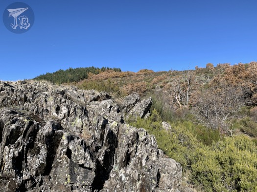
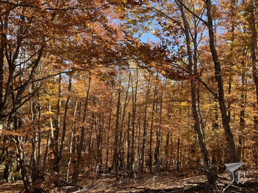
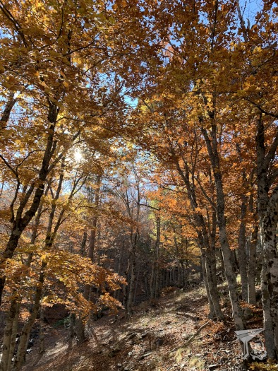
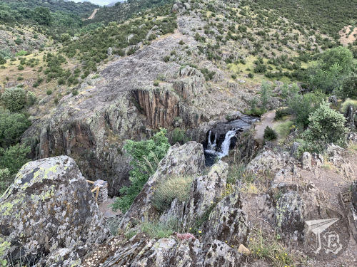
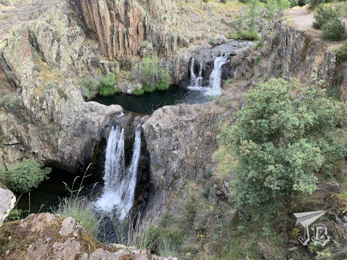
The spot I wanted to reach were the Mingo Negro Gullies Cárcavas de Mingo Negro, in the municipality of Alpedrete de la Sierra, within the nature reserve Parque Natural Sierra Norte de Guadalajara. Gullies are erosive landforms usually created by a combination of running water, especially torrential rains and floods, and small landslides as the sediment collapses. Gullies tend to be devoid of vegetation and generally quite vertical, as they commonly form on steep landscapes, often on sandstone or conglomerate soils. These particular gullies are the remains of an alluvial fan, an accumulation of sediments characteristic of mountain areas in semi-arid climates, which opens as it leaves a confined area, so when you look at it from above, it resembles a fan – hence the name. Gullies are common in badlands as the dry terrain is drained downwards and no vegetation holds it. They are considered to be unstable landscapes.

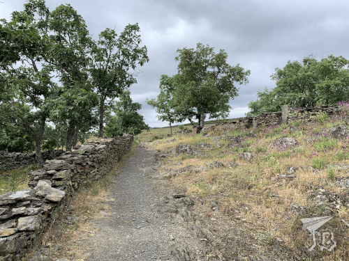
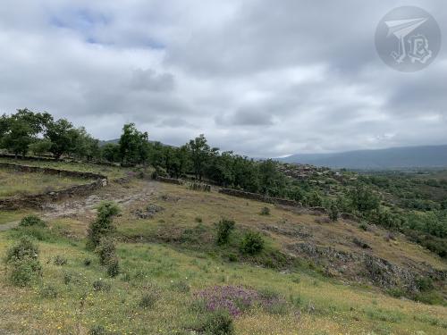
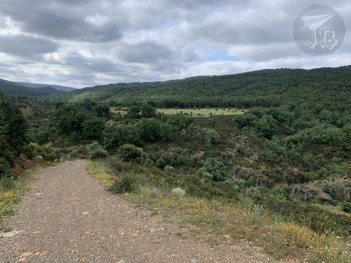
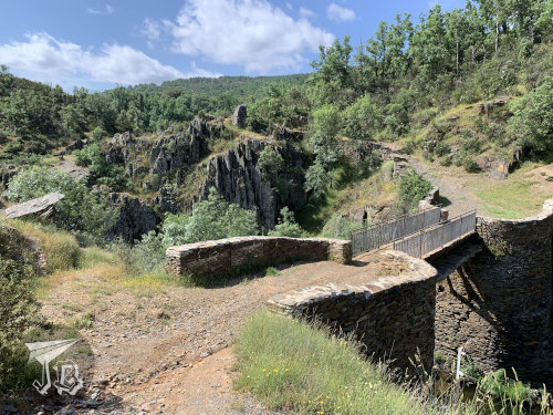
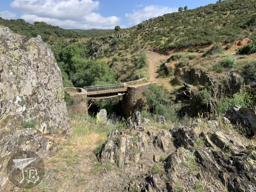
The Mingo Negro Gullies are on the left bank of the River Río Lozoya. A dam Presa del Pontón de la Oliva was built to contain the river in the 19th century, and though it is still standing, it could not be used as a reservoir. There is a kind of road / bridge that crosses the river and leads to the trail. It was rather easy to follow at first, but eventually I reached the steep part. Though there is technically a trail there, somewhere, the ascent is not easy to follow due to poor maintenance and water erosion. Hiking up the 370-metre slope took me about 20 minutes, and it was tiresome for but not as hard as I had pictured. To be fair though, I’ve recently bought a hiking pole and that was helpful. The terrain was a bit unstable and I kept my eyes on the ground, which is why I almost missed the first sight of the gullies (a later visit to the area revealed that I should have already seen them from right out of the parking lot, but the sun was in my eyes).

A landscape of reddish gullies in the far background

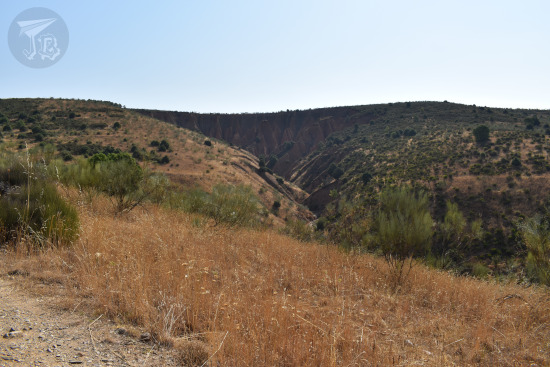
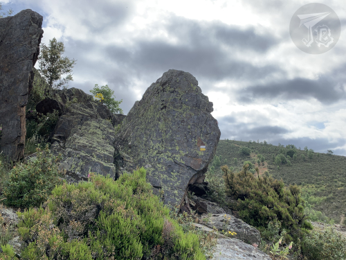
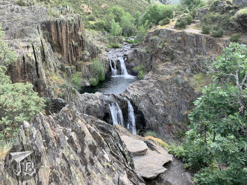
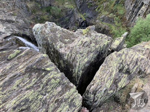
The trail is not well maintained, so plants are overgrown. If you actually want to see anything of the gullies you have to go past the “do not cross” signage, even at the viewpoints. However, you have to be very careful not to approach the border as the terrain is inherently unstable. While I was coming up, the sun masked the clay-red colour a little, which was a pity.

A landscape of reddish gullies

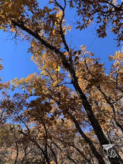
Though some of the online-sourced routes do so, it is also ill-advised to go into the actual gully, so I just stayed in the upper part along one of the marked trails. I did step beyond a couple of barriers, but made sure to stay a respectable distance from the border. I ventured through some of the secondary paths for pictures on my way down. However, I did not go down to the ravine, as cool as that must be, because there is a risk of collapse.

A landscape of reddish gullies with hills in the background

A landscape of reddish gullies

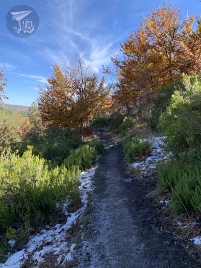
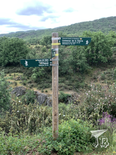
There are several trails that go to or around the Cárcavas de Mingo Negro, the most common of it circular. However, I did not feel like doing that one, which takes over four hours. I wanted to see the dramatic gullies, so once I was done around that area, I turned back using the same trail I had used to climb up. By that time it was around 11:00, and though I had seen nobody on my way there, now I started meeting people climbing. A family became quite indignant because I was not following the circular trail. Someone else had decided to tackle the hike in flip-flops. Some people are… peculiar.

There is a bar somewhere at the beginning of the route, and there were some buildings indeed. However, it was either closed – or I did not find it. I had thought I would stop for breakfast there, and then head to do something else.

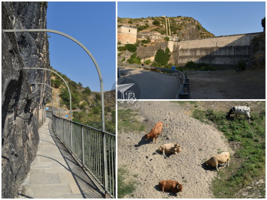
I reached the Presa del Pontón de la Oliva dam again. The structure, in the municipality of Patones, belongs to Madrid’s Water Management system Canal de Isabel II and it is considered local heritage as it was the first dam built in the area. Madrid became the capital of Spain in 1561, and in the 19th century its population was growing fast. Water was obtained through fountains, whose waters came from underground water canals built 400 years prior. From the 18th century onward, architects started studying how to channel water from the nearby rivers into the city. Part of this program yielded to building the dam between 1851 and 1856 with the idea to create a reservoir. The structure is a gravity dam, with a height of almost 30 metres and a width of 72 metres at its longest. Two years after it was built, the rest of the project was completed, and water reached Madrid. However, the location had not been correctly chosen – water filtered through the rock walls to the sides and underneath the ashlar construction – and in 1904 the reservoir was closed down, so water flows freely through a tunnel under the construction.

I heeded the “flood plain, do not enter” warnings, but neither Sunday hikers nor free-range cows did. I remained on the upper area and explored a little of the area called “the balcony”, built alongside the dam to admire the structure. There is another hiking route, Ruta del Agua that starts there, but again, this was not something I wanted to tackle today, as it was my first day out after a long period at home. Had I found the bar open, I would have hiked further (the whole route is about four hours though, so it was probably good I did not).

Dam - Pontón de La Oliva with some cows grazing. Since the dam is no longer in use, the area around the dam is dry

In the end, I headed back to the car and drove off. I thought I might stop to see a windmill on the way, but I somehow missed the turn to the hamlet where it stands. I was almost surprised when I saw the road sign for the last village before home. All in all, I saw what I wanted to, and found a nice easy drive with further routes that can be taken and enjoyed in other circumstances. I think I can reasonably squeeze a couple other visits to the area.

12th November 2021: Beech Unplugged – Hayedo de la Tejera Negra (Spain)

One of the Unesco World Heritage Sites is “Ancient and Primeval Beech Forests of the Carpathians and Other Regions of Europe”. The “other regions of Europe” actually makes the site expand into 94 forests in 18 European countries – three of these forest are in Spain. A primeval forest, in layman’s terms “old-growth forest” is one that has been allowed to thrive without significant alteration from humans. Most of Europe’s temperate forests have been altered by human activities, so the protected areas are patched throughout the continent.

One of the protected areas is the beech forest Hayedo de la Tejera Negra. The European beech (Fagus sylvatica) is a deciduous tree from the same family as oaks. The trees usually measure up to around 30 m, tend to have a slim trunk and grow branches high on the tree. The leaves are simple, though they are toothed, the shape is soft. They change colour in autumn from green to gold and tend not to be shed but stay in the tree unless the weather brings them down. They grow in humid areas, but they require a well-drained soil. Forests tend to be thick and dark, with few other species as the beech canopy takes up all the light.

The forest is located in the centre of Spain, and it is part of the natural park Parque Natural de la Sierra Norte de Guadalajara, some 30 km away from the Aljibe Waterfalls. Beech forests tend to grow in colder climates, so this one is a relict forest from times when Spain was cooler and wetter (maybe what is called the Little Ice Age between 1300 and 1850). The fact that it remains is due to a very precise location – low valleys with a lot of shades and shadow where fog and mist are common and it rains rather often. Furthermore, the calcite-rich area makes the soil ideal for beeches. The reality of it being a Primeval forest is thrown has doubts cast as the forest was actually cut down twice – 1860 and 1960.

The beech forest technically belongs to Cantalojas, in the north of the province of Guadalajara, Spain. There is an inner parking lot that has to be reserved in advance for just under 5€ (access between 10:00 and 13:00), and a free-access parking lot at the edge of it. In order to get there, the first step is to arrive in Cantalojas. There, a bumpy rail gets to the beginning of the park, where the checkpoint stands, you can either leave your car here and walk the longer trail (Senda del Robledal), or if you have an inner parking reservation, you will get waved through the longer driving path, 8 km long. Once in the parking lot, you may walk the inner trail.

After my first try to visit the park was fouled by the driving path being closed on weekdays and the parking lot full, and my second by the bad weather, I was finally on my way on Friday the 12th of November – took long enough! The roughly 100 km took a bit more than expected due to a good part of the road having a lower speed-limit than normal, as it is considered a “dangerous mountain road”. There is also loose cattle around the roads, and I came across a few cows having a field day. In the end, I drove for an hour and forty-five minutes, and started walking around 11:30. I took the shorter, inner trail, called Senda de Carretas, which is around 6 km long. Depending on which resource you look at, between two and three hours are expected to hike it.

The trail starts in the lower valley, between the creek Río Lillas and the lower pine forest, whose trees won’t lose their leaves anyway. Thus, even if the weather is turning cold this area is still very green. The name of the trail translates into “Trail of Carts” as it was used in the past to transport coal that was produced in the beech forest. As the trail turns to the left, it starts ascending, leaving behind the valley and the pines. First, there is an area of low bushes and trees, where pieces of calcite rock are abundant, then it delves first into the oak forest, which has already turned brown.

A sign reading Senda de Carretas. Behind it, a small valley. A creek runs at the bottom, and the sides are covered in pines and other evergreen trees.

A rock formation, with vertical cracks, and bushes in the background

Beech trees, looking brown / orange / golden in the autumn weather.

There were way more people than I had been expecting for a weekday – a lot of them were hiking in groups and unfortunately loud, which made catching a glimpse of any animal impossible. The forest was beautiful though. Around one-third in I came across the sculpture that recreates the old coal-ovens, La Carbonera.

A hut made out of thin trunks. The autumn leaves have accumulted against

I continued hiking up, and after a pretty wooden bridge, the steep slope started. This was a bit harder than I had anticipated, and made the mistake of taking a break in-between, so I lost my pace. At the end of the slope I found the open prairie Pradera de la Mata Redonda, which looks down on the valley and up onto the multi-coloured mountain.

The valley from above. There are no trees, but a high plane with bushes and scattered grey rocks covered in lynchen

After a short look-around, I continued on the hiking path. Here I could actually see something unexpected… snow! Do you remember that my second attempt had been thwarted by the weather? Well, there were the remainders of so… This was in my opinion the most beautiful part of the forest, as the descend starts. The beech forest was completely golden at this point, and the ground was also covered on leaves. This is the part that gives the forest its fame, and it is well-deserved, at least in autumn.

Grey path into the forest. On the sides there are brown / gold trees, green bushes, and even a bit of snow.

A whole forest of beeches in gold, brown and golden colours; the ground is covered in leaves.

When I reached a fork on the road, I continued for a little on the Senda del Robledal (Oak forest trail), then took the path down towards the parking lot. The forest opened up and I eventually got to the parking lot, where I got on the car and drove away at around 14:45. I took a little over three hours in total and walked 7.46 km.

A whole forest of beeches in gold, brown and golden colours; the ground is covered in leaves

On my way back I drove past more cows chilling out – the complete drive was a bit under 200 km. And I did not have signal for the whole day, which was a nice change for a while.

A black cow chilling at the side of the road - they actually have the right of way in this area

3rd June 2021: Hike to the Aljibe Waterfalls (Spain)

The Ayllón Mountain Range or Sierra de Ayllón is the of the chains that conforms the Spanish Central System Sistema Central, on its easternmost edge.

The Central System was formed during the early Cenozoic Era (the current geological era) in a process called the Alpine orogeny – when the African tectonic plate crashed against the Eurasian plate, a geological event that gave way to the main European and Asian mountain ranges, from Spain in the west to Java in the east.

It rests on a granite base that became first folded, then fractured during the formation of the system. As the rocks eroded, the sediments deposited and formed new sedimentary socks. Other processes that influenced the formation and shape of the ranges have been the action of glaciers and rivers and the subsequent weathering of the exposed rock.

The most common rocks in the Ayllón Range are granite, as expected, gneiss, and slates, some of the latest mixed with clays. For centuries, the villages of the area have been known as “black villages” (pueblos negros) as slate has been extracted to build them. One of such villages is Campillo de Ranas, which translates to something akin to “Little Field of Frogs”, and one of the neighbourhoods adjoined to them is Roblelacasa (literally Oak-the-House).

Roblelacasa happens to be the start of a hiking route to one of the highlights of the range – the Pozas del Aljibe (Aljibe Pools), with Aljibe being a word of Arab origin that means “cistern” or “well”, so not that original a name, I guess. I had been wanting to see these pools – also called a waterfall – for a while, so I decided to drive off and hike the route to see the Aljibe, which is considered one of the most beautiful in the centre of Spain. The hike is about 3.3 km each way – but guess what? I ended up taking a detour or two (≧▽≦). The pools are formed by the Soto Creek, Arroyo del Soto, a tributary to the river Jarama which in turn flows into the river Tagus.

Off I went. The drive took about an hour and twenty minutes. I left home around 8.20 and arrived in Roblelacasa around 9:40. The drive went well, most of the road was a nice national road, and as it was a local holiday traffic was scarce. Some people were in a great hurry though, ignoring speed limits. This was my first time driving on my own with the Sat-Nav, and it went all right. However, as I drove towards the range, there was a dark cloud I did not like one bit.

Just after reaching the “village”, I found a parking spot right behind the panels, as the expected parking lot was closed off. I had packed some frozen water, biscuits, the camera and my cap – but I had forgotten the umbrella, and it was a bit grey. I decided to leave taking pictures of the village for later, and I started walking just behind a couple who had arrived virtually at the same time, but I passed them as they stopped to take pictures.

Information

Roblelacasa

The route is officially named “PR-GU 09: Sendero de los pozos del Aljibe” and it is part of the natural park Parque Natural de la Sierra Norte de Guadalajara. Upon leaving Roblelacasa, the first couple of hundred metres crossed fractured and weathered rock before crossing a symbolic gate that marks official the beginning of the trail with a white and yellow double-line. Then, I walked onto a gravel path flanked by the remains of old fences. To the left opens a valley, and looking back I could see the village, in black.

Start of the route

Old slate fences

Valley

Valley and village

The route widens into a dirt track that is obviously travelled by car sometimes, as the range peaks stand in front of you. There are no trees but a lot of bushes and aromatic herbs, and as you walk the scent is very pleasant. Then there is a small forest and a second barrier, which marks the turn where you are going to start climbing a new hill – slowly, the terrain rises to your left while it lowers on your right, giving way to the creek’s valley. Just before reaching this I passed a family who had started walking before me.

Mountain Range in front

Mountain Range around

Eventually, you reach a fork in the trail, with the choices of going left towards the waterfall or right down the valley to see a former dam-turned-bridge. I went to the waterfalls, figuring out that I could always go down to the dam on my way back. The track became narrower and rocks started popping up again.

Fork on the way

Valley

Creek in the valley

Geological formations

I wandered off the trail (you can see the markings on the upper picture) a couple of times because the views were neat, but a few minutes later I crossed a little bridge to get access to the waterfalls viewpoint on the left-hand-side bank… which was closed. Believe it or not, the actual waterfall area had quite a few “do not walk, falling risk” signs that… okay, I have to be honest… I pretended not to see. I hiked up to the viewpoint and sneaked a little to the side to see both waterfalls. As it has been storming, there was a good amount of water flowing, so the view was pretty cool.

Wooden Bridge

First waterfall

The upper waterfall is about three metres high, and the easier one to see, without needing to ignore any warning sings. When I walked up to the viewpoint I got an amazing view of both the upper and lower waterfalls, the latter being about 7 metres high. It is easy to see how they are called either waterfalls or pools.

Both waterfalls from the left bank

Both waterfalls from the right bank

Remember that I said that I passed a family on my way up? This is kind of important because it means that I was basically alone in the waterfall area for about ten minutes, enough to take a good bunch of pictures from both banks of the creek without having to edit people out. I was however very cautious about cracks and faults. I think most of the rocks in the area are quartzes but my geology skills are a bit rusty.

Cracks on the rock

As I decided to turn around, the family arrived, and so did the couple I had first passed and another group that must have started behind me. That was okay because I was done, and on my way back I could stop for a lot of pictures that I had not taken before. Here you can see the difference between the quartz /gneiss (surrounding the flowers) and the slate (in the middle).

Flowers growing from the rock

Also, at some point before I started my return hike, it cleared up. All of a sudden it was hot so first I shed off my sweatshirt and when I reached the crossroads again I really needed a drink and some shade – but I had packed water and the cap, so everything was fine, and I could divert to see the old dam, Presa de Matallana over the creek Soto – from both sides. This must have been around 11 am.

Valley on the way back

Presa de Matallana from the left bank

Presa de Matallana from the right bank

I turned back towards Roblelacasa and I noticed that the wide track was a bit more “upwards” than I had noticed the “downwards”. I had a bit of a tired moment as I adjusted to hiking up in the heat – why is it that normal hills tire me more than uneven paths? But it was over in five minutes and I was back in the village a bit before twelve. On the way now I stopped to take pictures of the flowers and bushes around, and of the valley that Roblelacasa overlooks – and ran into four or five more groups / couples who must have started walking around 11, so it was a good call to get there early.

The track back

Roblelacasa from the outskirts

Flowers on the way

This is how the village looks in the light of day, just before I took the car and drove back around noon. I decided that I would go back to the area some other time to explore other villages around, mainly Tamajón, which is reported to have an interesting geological area, and some other black villages.

The village

Oh, and a the pictureless anecdote of the trip, for obvious reasons. There were a lot, and I mean a lot of “caution wildlife” traffic signals, and on the drive there I thought that I had very rarely encountered any wildlife crossing the road. I had also not come across any wild (or domestic) on the trail, aside from some little lizards and a few pet dogs with their owners. Well, good thing I was driving a good 10 kph under the speed limit, because on the drive back I had to yield to a wild boar! Live and learn (to drive slowly in wildlife areas)!

Driven distance: around 130 km (2h 30min)
Hiked distance: 6.7 km / 11,106 steps (2h 20min)