23rd August 2025: Cárcavas de Mingo Negro (Spain)

For all the solo exploring I do, I still second-guess my abilities when something I want to see involves a reported-as-difficult hike. However, I got tired of waiting for people who had expressed interest in tagging along for this small adventure. Thus, when the summer heatwave gave way to more bearable temperatures for a couple of days, I drove to the area. There is a convenient parking lot to leave the car without breaking any laws and since I reached it before 9:00, it was still reasonably empty, even if it was a weekend. I changed into my hiking boots and got on walking.

The spot I wanted to reach were the Mingo Negro Gullies Cárcavas de Mingo Negro, in the municipality of Alpedrete de la Sierra, within the nature reserve Parque Natural Sierra Norte de Guadalajara. Gullies are erosive landforms usually created by a combination of running water, especially torrential rains and floods, and small landslides as the sediment collapses. Gullies tend to be devoid of vegetation and generally quite vertical, as they commonly form on steep landscapes, often on sandstone or conglomerate soils. These particular gullies are the remains of an alluvial fan, an accumulation of sediments characteristic of mountain areas in semi-arid climates, which opens as it leaves a confined area, so when you look at it from above, it resembles a fan – hence the name. Gullies are common in badlands as the dry terrain is drained downwards and no vegetation holds it. They are considered to be unstable landscapes.

The Mingo Negro Gullies are on the left bank of the River Río Lozoya. A dam Presa del Pontón de la Oliva was built to contain the river in the 19th century, and though it is still standing, it could not be used as a reservoir. There is a kind of road / bridge that crosses the river and leads to the trail. It was rather easy to follow at first, but eventually I reached the steep part. Though there is technically a trail there, somewhere, the ascent is not easy to follow due to poor maintenance and water erosion. Hiking up the 370-metre slope took me about 20 minutes, and it was tiresome for but not as hard as I had pictured. To be fair though, I’ve recently bought a hiking pole and that was helpful. The terrain was a bit unstable and I kept my eyes on the ground, which is why I almost missed the first sight of the gullies (a later visit to the area revealed that I should have already seen them from right out of the parking lot, but the sun was in my eyes).

A landscape of reddish gullies in the far background

The trail is not well maintained, so plants are overgrown. If you actually want to see anything of the gullies you have to go past the “do not cross” signage, even at the viewpoints. However, you have to be very careful not to approach the border as the terrain is inherently unstable. While I was coming up, the sun masked the clay-red colour a little, which was a pity.

A landscape of reddish gullies

Though some of the online-sourced routes do so, it is also ill-advised to go into the actual gully, so I just stayed in the upper part along one of the marked trails. I did step beyond a couple of barriers, but made sure to stay a respectable distance from the border. I ventured through some of the secondary paths for pictures on my way down. However, I did not go down to the ravine, as cool as that must be, because there is a risk of collapse.

A landscape of reddish gullies with hills in the background

A landscape of reddish gullies

There are several trails that go to or around the Cárcavas de Mingo Negro, the most common of it circular. However, I did not feel like doing that one, which takes over four hours. I wanted to see the dramatic gullies, so once I was done around that area, I turned back using the same trail I had used to climb up. By that time it was around 11:00, and though I had seen nobody on my way there, now I started meeting people climbing. A family became quite indignant because I was not following the circular trail. Someone else had decided to tackle the hike in flip-flops. Some people are… peculiar.

There is a bar somewhere at the beginning of the route, and there were some buildings indeed. However, it was either closed – or I did not find it. I had thought I would stop for breakfast there, and then head to do something else.

I reached the Presa del Pontón de la Oliva dam again. The structure, in the municipality of Patones, belongs to Madrid’s Water Management system Canal de Isabel II and it is considered local heritage as it was the first dam built in the area. Madrid became the capital of Spain in 1561, and in the 19th century its population was growing fast. Water was obtained through fountains, whose waters came from underground water canals built 400 years prior. From the 18th century onward, architects started studying how to channel water from the nearby rivers into the city. Part of this program yielded to building the dam between 1851 and 1856 with the idea to create a reservoir. The structure is a gravity dam, with a height of almost 30 metres and a width of 72 metres at its longest. Two years after it was built, the rest of the project was completed, and water reached Madrid. However, the location had not been correctly chosen – water filtered through the rock walls to the sides and underneath the ashlar construction – and in 1904 the reservoir was closed down, so water flows freely through a tunnel under the construction.

I heeded the “flood plain, do not enter” warnings, but neither Sunday hikers nor free-range cows did. I remained on the upper area and explored a little of the area called “the balcony”, built alongside the dam to admire the structure. There is another hiking route, Ruta del Agua that starts there, but again, this was not something I wanted to tackle today, as it was my first day out after a long period at home. Had I found the bar open, I would have hiked further (the whole route is about four hours though, so it was probably good I did not).

Dam - Pontón de La Oliva with some cows grazing. Since the dam is no longer in use, the area around the dam is dry

In the end, I headed back to the car and drove off. I thought I might stop to see a windmill on the way, but I somehow missed the turn to the hamlet where it stands. I was almost surprised when I saw the road sign for the last village before home. All in all, I saw what I wanted to, and found a nice easy drive with further routes that can be taken and enjoyed in other circumstances. I think I can reasonably squeeze a couple other visits to the area.

25th May 2025: Gozo Tour {Malta, May 2025}

I had booked a second tour, in order to get to know the Island of Gozo. This time around though I had a very clear pick-up point, which I hoped would work out, unlike the previous day. Fortunately, the instructions from Gozo Tours were extremely clear and I knew exactly where the pick up point was, without any non-working links. There were other people from my same hotel, so we got nervous together. The driver was not too late though. We were driven in a mini-van towards the passenger terminal in the north of the island, Cirkewwa. There, we waited for pick-ups from other parts of the island. We had a charter high-speed boat that crossed the Gozo Channel and dropped us off at the Mgarr Harbour terminal in the second-biggest island of Malta (country).

Gozo | Għawdex is less urban than the Island of Malta, so I had decided that maybe the Full Day Jeep Safari Of Gozo could be a good way to get a feeling of the island, without having to plan much and depend on public transport. In hindsight, it was probably unnecessary but it eliminated the need to plan. All in all, the tour was convenient, but not something I would choose again – the landscapes were beautiful and dramatic, but not as crazy as I had expected.

I became really amused at how many people (read: most everyone) were unaware of the speed a speedboat reaches. I was glad that the boat was so fast; it glided over the wind-waves, and there was no swaying. That was good, because said wind would have made the trip miserable at a slower speed. However, there was a group of Italian girls who were absolutely petrified.

We reached Mgarr Harbour in Gozo and separated into small groups for the different jeeps. I was placed with four Londoners and an English guide, which suited me just fine. I don’t remember whether I actively chose the English-speaking tour, or I got assigned to one because I used the English webpage. There must have been tours in other languages. Apparently, all the jeeps go to the same spots at different times of the day so they don’t run into each other, so we followed a bit of a zigzagging route, with specific spots in different cities and towns. The information said there would be a “swim stop” during summer, I was just not sure whether the 25th of May would count as summer. I carried my swimsuit and towel anyway.

The first stop was barely five minutes in: Qala Belvedere, a panoramic spot in the town of Qala, which allowed us to catch sight of Comino, the third-biggest island in the archipelago. Afterwards, we got back on the jeep and headed off towards Ramla Bay in Xaghra. As he was describing the landscape, the guide at some point mentioned volcanic rock, which threw me off, as I believed that the islands were sedimentary. I thought maybe he meant there was some tuff. However, everything I have read about the geology of the islands agrees – the whole of them is sedimentary rock, in five main strata. From oldest, at the bottom, to newer, these are coralline limestone (Żonqor), globigerina limestone (Franka), blue clay mudstone (Tafal), greensand sandstone (Ġebla s-Safra) and coralline limestone again (Qawwi ta’ Fuq).

The Upper Coralline limestone formation (the most recent) is pale and grey, and it is embedded with biological structures. The most important rock is the globigerina limestone, which is golden and between 23 and 14 million years old. It is called so because it contains a lot of globigerina – a type of plankton – fossils (I did see a lot of shells in the rocks, but I was not carrying anything to dig the fossils out). This is the majority of building material in the country, even in a lot of the prehistoric temples. It has been designated a Global Heritage Stone Resource, something I did not even know existed until now. The blue clay is also key in Gozo as it is the one that allows for the creation of freshwater aquifers through the filtration of rainwater. The thing with limestone is that it erodes very dramatically, creating very capricious forms which are the base of the striking landscapes in the island.

The shore of Ramla Bay is one of the few sand beaches in the country. It is called Ramla il-Ħamra (Red Sands) because of its reddish colour due to the presence of iron clay in the area. The beach is locked by two rocky formations / cliffs that protect it from the waves – unfortunately, not from real estate developers.

Ramla Bay - a small reddish sand beach inbetween rocky cliffs

We continued towards Xwejni Bay in Żebbuġ. It has a small beach of pebbles, with a promontory to one of the sides, and a dramatic walk along the other side which leads to the salt pans. Unlike the ones from Birżebbuġa, these pans are commercially exploited. Between May and September, each pool is filled, individually and manually, with sea water which proceeds to evaporate and leave behind the dry salt crystals. With good weather, salt can be harvested once a week, and it is sold as flakes without further processing – rather nice, I’d say. We also were shown to a small shop that had tastings in hopes you bought stuff, and I did try the salt and the oil.

Xwejni - a beach made by the erosion of limestone, with salt pans excavated into it

We drove by Basilica of the Blessed Virgin Of Ta’ Pinu | Santwarju Bażilika tal-Madonna ta’ Pinu, though we did not stop. The current building is Neo-Romanesque – construction started in the 1920s – and it looks like something from a fantasy cartoon. However, it is a serious Catholic temple, dating back from the 16th century at least, even if it kind of stands in the middle of nowhere.

We crossed the town of Għarb and made a short stop at the SG 8 globigerina limestone quarry. It made me sad that the SG did not stand for “Stargate” but what can you do? The quarries through the island extract the rock which is used as construction material in many buildings through the country.

Limestone quarry

Instead of going to the other side of the galaxy, we headed off to San Lawrenz to see the Inland Sea | Qawra, a lagoon connected to the sea through a cave fault in the cliffs. When the weather is nice, there are boats giving you a ride past the archway and out to the sea, but not this time around – there were some pretty decent waves coming in, so it was too dangerous to sail the crossing.

Small lagoon connected to the ocean by a cave

We drove through Għarb again, where I could catch a glimpse of the Basilica and Collegiate Parish church of the Visitation of Our Lady, and continued towards Xewkija where we were to have a “three-course course light lunch”. This consisted on a Ricotta Pastizz (pastry stuffed with ricotta cheese), Maltese Bragioli | Beef Olive (stuffed beef roll), and vanilla ice-cream, along with wine that I did not have, I went for water instead. Food was all right, I was not hungry so it was fine. Afterwards, the guide offered to take us to a gelateria to have “the best ice-cream ever”.

Pastizzi (pastry filled with cheese), and a meatball with potato wedges

Before that, we crossed the scorching square to see the Rotunda St. John Baptist Church | Basilika St. Johannes der Täufer, which had recently been struck by lightning. This is a Baroque church established in 1678, though the building was erected in limestone in the mid-20th century. The new building actually encased the original church, which now is a small chapel to the left side of the main altar. St John is the Spiritual Seat of the Knights Hospitaller.

Neoclassical church with a dome

The next stop was Xlendi Bay and the beach town of Xlendi. There stands Xlendi Tower, built by the Knights in 1650, restored in 2010. The natural landscape was stunning, but the town itself was just a touristy beach town. The promised ice-cream parlour was a chain called Gelateria Granola, where I decided to try the cookie ice-cream, because it was something I had never come across before, and I had next to no time to choose, it felt – I have no idea how I ended at the front of the crowd.

Xlendi: cliffs and breaking waves

Ice-cream happily consumed, we drove off. We stopped in Fontana where there is a natural water spout called the Knight’s Wash House, halfway between a historical landmark and a local fountain. As a curiosity it was all right. We continued to Victoria, whose historical seed is called The Cittadella | Iċ-Ċittadella, the Citadel. The area comprising the Cittadella was first inhabited during the Bronze Age, and it probably went on to become the Roman acropolis and eventually a castle in the Middle Ages. The castle defences were reconstructed in the 17th century, but they were not considered the best – the Cittadella actually surrendered in the 1798 French invasion and counterstrike, without much resistance either time.

Our allotted time there felt too long for just a walk and too short to the whole thing, unfortunately, so I could not snoop around the museums. Furthermore, the Cathedral of the Assumption – The Matrix, Parish Church, Sanctuary, Collegiate and Cathedral of the Assumption of the Blessed Virgin Mary into Heaven | Parrocca Matrici, Arcipretali, Santwarju, Kollegjata Insinji u Katidral ta’ Santa Marija Assunta was closed. The whole area looked like it would be awesome to be able to sleep over there – especially because walking uphill to visit it would be hard in the sun.

Fortification made in limestone with a baroque cathedral

The hour approached to head back to the quay. We started making our retreat with two short stops on the way, in the town of Għajnsielem. The first one was for the guide to take our pictures with the Monument to the bench in the village square, a metal bench showcasing a pair of grandparents, a young woman with a smartphone and a cat begging for attention. The bench is located in front of the Għajnsielem Parish Church. The second stop was a panoramic view of Gozo Straight and the Church of the Madonna of Lourdes | Knisja tal-Madonna ta’ Lourdes. There was no swim stop in the end, so late May is not summer yet. All in all, we started off around 10:00 and were done by 16:00, and it cost 80 €.

We made it back to Mgarr Harbour, where we took the speedboat back, first to drop off some passengers in Comino, which gave us a peek into the Blue Lagoon there. Again, I was glad for the speed, because the waves would have made a leisure trip miserable. Afterwards, we were driven back our points of origin. Back in my hotel, I snacked on some salt-and-vinegar crisps from my favourite British brand that I had found in the supermarket.

The turquoise water of the blue lagoon in front of the island of Comino

Around sunset, I went out to explore Saint Julian’s | San Ġiljan a little further. I had considered some of the typical restaurants there, but since I ate the crisps I was not hungry. What I did was walk around Spinola Bay, along Spinola Slipway and Saint Julian’s Promenade, and past the Fisherman Monument – with yet another cat begging. I tried to reach the marina, but it was all uphill and taken over by the luxury hotels.

A sculpture of a fisherman cleaning the nets while a cat looks eagerly at him, and a view of an urban bay front

Instead of dinner, I had another snack, and then headed off back for a shower, some sleep and… yes, another 5:00 wake up call. Talk about jet lag without changing your time zones!

9th March 2025: Expominerales 2025, the other half of the weekend’s plans (Madrid, Spain)

Since I had to be in Madrid to watch the fantastic concert by the Wiener Sängerknaben, the plan had been to attend the yearly Expominerales mineral fair in the Mine and Energy Engineering School Escuela Técnica Superior de Ingenieros de Minas y Energía (ETSIME) that same day. However, the fair closes on Saturdays between 14:00 and 16:00 for a lunch break, so since the weather was so horrid, I decided not to wait. On Sunday, the weather forecast was slightly less miserable, and in the end I was lucky with only some gentle rain as I walked between the train station and the Engineering School, nothing like the sleet deluge the previous day.

Expominerales fills the ETSIME with stalls selling minerals, fossils and crystals offered by reputable sellers. Here I’ve seen the biggest megalodon teeth in my life, held a plesiosaur vertebra – which I regret not buying when I had the chance – and discovered that moldavite exists – and which I regret not buying when I had the chance… do you spot a pattern here? I did not break it anyway, because in the end I cannot afford most of what is sold, and I already own most of what I can…

Overlook of ETSIME during Expominerales

I arrived at the School shortly after the exhibit opened around 10:00, and the area was still pretty empty. There were fewer stands than the previous years I’ve been there, and the moldavite stand was not there. Actually, there were very few meteorite-related stands this time around. I did see amazing modern-times frog fossils from Owens Lake. Owens Lake is called Patsiata in the Mono Native American language. In 1913, the lake dried out when the water from the Owens River was redirected and with years it has become a deadly salt flat, a source of alkali sand storms with a side of carcinogen materials. One of the minerals found in Owens Lake is trona, a crystal formed by the precipitation of sodium carbonate, making it a type of evaporite. In 2023, an atmospheric river caused floods in California, filling the lake up for the first time in over a century. The floods damaged infrastructure and created a surge of floodwater to the lake, which eroded surfaces and dragged a lot of small hibernating animals towards the lake, where they were killed instantly. Their soft tissues were quickly replaced by trona salt before the bodies even decomposed, creating a perfect cast of the poor critters. There were two on display at Expominerales and they were creepy!

Something else that caught my eye (and was actually within my doable price range) was a polished abalone shell. The Korean abalone (Haliotis discus) has been used for centuries in the art of najeonchilgi [나전칠기], which refers to decorating items with mother of pearl. The abalone can be polished in full, creating a whole iridescent body of nacre. These mollusks used to be collected by haenyeo [해녀], traditional female divers from the Jeju province, but most of them are farmed for food today. A small polished abalone came home with me.

Items from Expominerales

The School opens its classic museum during the exhibit, and I always enjoy visiting it. However, after wandering around for a bit (and spending some money), I moved onto what basically is the next building over to the ETSIME, the Spanish Mining and Geology Institute IGME – Instituto Geológico y Minero de España, which hosts the Geomineral Museum Museo Geominero. The original design of the building was conceived by Francisco Javier de Luque, and work started in 1921. Though a congress was held there in 1925, construction went on until 1941. The building has not been extensively restored, but it presents deviations from the original plans, and even from subsequent ones.

The museum is hosted in the former hall, and to get there, first you have to go through a very bored security guard – who first asked if I was sure I wanted to be there. Once inside the building, one goes up the main staircase towards the gallery underneath a glass-and-iron skylight with the logo of the Mining Institute. It was designed by Luque himself and created by the Madrid workshop La Veneciana, a glassware shop dating from 1876 and which, under a different name, still exists today.

Entrance staircase to the Geomineralogical museum

The museum is an open area, located underneath another incredible skylight. The displays are hosted in wooden cabinets in the main floor. The upper balconies can be accessed through spiral staircases and are protected by metalwork railings. One of the details I absolutely adore are the glassworks displaying geological sample cores of different surveys. I’ve never seen the library, but I was once part of a group which was allowed to play with some of the “lesser value” items they have as part of a training session, and that was super fun. The museum is probably one of my favourite spots in town.

The Geomineralogical Museum

From the architecture point of view, I like the building and the skylights. However, there are way more things to love in the museum, such as the wooden cabinets, full with samples of minerals, fossils and meteorites. The museum’s collection are divided into “Mineralogy and Petrology”, “Flora and Invertebrate fossils from Spain”, “Vertebrate fossils from Spain”, “Foreign fossils”, “Systematic invertebrate palaeontology”, “Micro-palaeontology”, “Fossil resin”, “Fossil tracks”, “Stromatolites”, and the “special exhibits”. One of these is a complete cavern bear (Ursus spelaeus), another one is an Ibex (Capra ibex). The last two have honour spots, with their own display.

When you come into the museum, one of the first things that you see, in front of the door, up on the first-floor balcony, is the cast of the most complete Tyrannosaurus rex skull ever found – Stan. Specimen BHI 3033, Stan, was found in 1987 and excavated in 1992, in South Dakota’s Hell Creek Formation. Stan lived around 65 million years ago, in the Cretaceous period. We know he fought for his life more than once – his ribs were broken and healed, two vertebrae were fused together, and he suffered a bite to his snout. Stan remains one of the most complete skeletons ever found, and probably the most-often cast. The skeleton made mainstream news when it was auctioned at Christie’s in New York due to money disputes among partners of the original owner-firm, Black Hills Institute. An anonymous buyer paid $31.8 million for it in October 2020. In 2022 it was disclosed that the Department of Culture and Tourism of Abu Dhabi had bought Stan for their projected new Natural History Museum.

On the ground floor there is a mastodon fossil Anancus arvernensis found in the 1990s. These animals related to modern elephants lived throughout the Miocene and went extinct in the Early Pliocene (two million years ago). The could have been around the size of a modern African bush elephants, but their tusks were mostly straight. They would have lived in steppe with dry and warm climate, but close to water. The fossilised bones were recovered are dated around 3.2 million years ago, and were dug from the Las Higueruelas site between 1948 and 1991.

Exhibits at the Museo Geominero

After I wandered the museum for a while, I left towards my train which was delayed… 43 minutes. Fortunately, so were the ones that had to pass before, so I ended catching one in the right direction after only a twenty-minute wait. And then I got junk food, because some days have to end in junk food…

7th October 2024: Pamukkale {Türkiye, October 2024}

Upset as I was, it took a long time to fall asleep, and I nearly had a heart attack when the hotel’s automatic wake-up call made the landline ring at 4:20 – half an hour before my alarm clock was set. We left around 5:40, and it was cold at that time, though it would get really hot during the day. Around sunrise, we reached our first destination – a caravanserai (kervansaray in Turkish, کاروانسرای, kārvānsarāy], in original Persian). Between the 2nd century BCE and the 15th century CE, Europe and China were communicated through the Silk Road, a network of trade routes frequented by caravans. Caravanserai were roadside inns built alongside those trade routes. They were fortified inns which protected the traders from bandits and weather, providing food and water. In Turkish, they are also called han.

Öresin Han (also called Tepesi Delik Han, “the han with a hole on the roof”) is a restored caravanserai / han. It was built in 1188, according to a plate that was recovered during restoration. The works lasted between 2007 and 2010, saving the building from literal ruins (and the aforementioned hole on the roof). Nowadays, it is a shop and inn for tourists. It has thick walls and a vaulted interior to withstand the weather and possible attacks.

Cansaverai

We continued on the road for hours until an early lunch at noon, then drove to the World Heritage Site Hierapolis-Pamukkale, a combination of historical site and geothermal activity. First and foremost, there is the travertine formation. Travertine is a sedimentary rock made out of calcium carbonate which precipitates from fresh water – basically, the material stalactites are made of. Sometimes, in thermal areas, they deposit in cascade form with lakes and waterfalls.

The Pamukkale travertine formation Pamukkale travertenlerinde is a terrace formation around 2,700 metres long, 600 metres wide and 160 metres high. The local thermal water oozes onto the surface at a temperature between 35 and 100 ºC and saturated with calcium carbonate. At the surface, carbon dioxide degasses and the calcium carbonate precipitates into a gel that will crystallise into travertine. Unfortunately, the waterfalls have been mostly drained now to feed pools at the hotels.

Even from the Classical era, the travertines have attracted visitors to the point that a thermal spa was founded around the 2nd century BCE, which eventually became the town of Hierapolis. In the year 133 BCE, Hierapolis was incorporated into the Roman Empire.

We had some time to wander around the place, but way too short to actually see even a quarter of what was on display, which was frustrating – but this would again happen at every archaeological site. Along one of the nice ladies from my group, I saw the Roman baths, then basilica, now museum, which contains the smaller items unearthed – sculptures, friezes, sarcophagi. We then climbed up to the Temple of Apollo Apolion and the Temple of Pluto Ploutonion – which are closed off as the cave underneath them emits asphyxiant carbon dioxide due to the geothermal processes.

Hierapolis museum

Hierapolis theatre

There is also a swimming pool on site, and after hiking up to the theatre it might have even been inviting, if not for the fact that you could actually step onto an area of the travertines to experience them first-hand. I of course took the chance, and was surprised at how… non smelly it was, used to sulphur thermal waters in Japan.

Pamukkale travertines

Travertines Pamukkale

I did not understand why we had to leave so early, because then we just ended up at another hotel with nothing around – thinking back, I have reached the conclusion that the guide was overworked, and he kept a schedule of going to sleep early and getting up early too, that is why we were at all the hotels at 18:00 at the latest; not an excuse, but an explanation. We were at Colossae Thermal & Spa Hotel around that time. The hotel did not have a lift, and most of our rooms were on the first floor. The hotel staff brought the luggage up, and we were reassured it would be taken down again the following morning. I… had a feeling it would not.

In accordance to the thermal and spring water reputation of the region, the hotel had a thermal centre. It comprised a swimming pool, a warm pool and a jacuzzi inside. Outside, there was an actual thermal water / mud pool – which was great for relaxing, but at 33 ºC, I could not stay for long (and I tried not to feel guilty as I knew the water is deviated from the travertines). By this time in the trip, too, I had inserted myself into a group of nice people, and made acquaintances with a nice couple, which was good because it’s always useful to have someone telling you that you’re about to get into the shower with your glasses on…

6th October 2024: Cappadocia {Türkiye, October 2024}

I had made a thing out of two coffees for breakfast, and today was no exception. The whole group was now in the hotel so we were ready to go see the sights. The bus had barely hit the road when our guide gave us a huge grin and decalred “I’m the first Turkish face you meet during this trip. Trust me. We’re going on the balloon is too expensive, so we’re not gonna do it here. We’re going to do it somewhere else”.

I was crushed at these words. Had he said this the previous day, I would have arranged to go onto the balloon on my own – today. Now, with a 5:00 departure time the following day, it was impossible. I don’t have words to write how I felt – devastated, cheated, furious. The option to ride a balloon in Cappadocia was in the documentation, and I had budgeted for it. And this guy had plain and simply… robbed me from it, because he did not want to wake up early after picking the other half of the group from the airport. Looking back, I should have tried to do it myself, hiring the flight on the hotel for today – and knowing that does not make it any better, because I could not do this one activity, which was important for me, not because of the weather or any actual problem. Just because the guide did not want to do his job. I did try to get him to reconsider, but he was like “no can do”.

Thus, I reached the conclusion that the travel agency, Oxin Travel and the guide himself sucked. Through the day (and the rest of the trip), I would build evidence on this – such as hearing explanations that did not make sense, or just contradicted what was written on the panels. I’m surprised it did not cross my mind to leave the trip at that time, because I was seething and heartbroken. In the past, I have tried to leave unsavoury experiences out of JBinnacle, but this would not be an honest trip report without all the emotions that coursed through me during that day – and to be honest, this was just the beginning of the problems. I wrote an email to the distributor that very same day, told the guide, and have complained formally to my travel agent. I have no hope for any solution, but at least I made it known that I was not happy with the services provided. And this trip was not cheap, at all.

I had to try to get over the disappointment in order to at least see what I could of the region. It was hard, I felt a cloud over my head ruining the mood. I almost did not care about anything else, but I knew I had to make do with what I had, or let my whole trip be ruined. Thus, I tried to get myself into the right mindframe to enjoy the World Heritage Site Göreme National Park and the Rock Sites of Cappadocia as much as I could.

Around 9:00, we reached Christian Keşlik Monastery Keşlik Manastırı outside the town of Ürgüp, which is a cave monastery. Human history in Cappadocia is tied to its geology. Tuff is easy to carve, and a lot of civilisations have made their dwellings into the earth instead of on it. First, it was the cavemen, and much, much later the Christians. The first buildings from the monastery date back from the 3rd century CE. Between the 1st and the end of the 4th centuries CE, Christianity spread through the Roman Empire, coming into conflict with the established religion, which deified the Emperor. As Christianity forbade idolatry, their refusal to adore the Emperor as a god made them a target of persecution, accused of treason. In some Roma cities, the Christians took to the catacombs. In Cappadocia, they dug cave monasteries.

Within the tuff structures, ancient Christians created all the items that one would find in a regular monastery – a church, two actually, St. Michael and St. Stephen, a refectory, a winery, dwellings, a baptistery created from a sacred spring… The monks could perform their rituals and protect themselves from any possible attack. It was a functioning Orthodox church well into the 20th century.

The most important cave-building in the rock is the Church of Saint Michael. Its ceilings are decorated with black backgrounds and colourful figures, although many were damaged by iconoclast movements. There were also tomb-like structures where the monks meditated. Underneath the church, there is a baptistery, and next to it the refectory, with a long table and seats carved out of rock. Outside, you can wander around the dwellings, halfway between caves and houses, which served as rooms for the monks.

Keslik Monastery Church of St Michael

Keslik Monastery - chambers inside the rock and panoramic

Afterwards, we headed out to the Underground City of Mazi Mazı Yeraltı Şehri, known in the past as Mataza. There are between 150 and 200 known “underground cities” in Cappadocia. They were initially carved between the 8th and 7th century BCE by the tribes which dwelt in the area. Turf is easy to carve and there is no water in the soil, which made it easy for the tribes to dig “caves” under their houses. These caves became “rooms” which ended up connected to one another through tunnels. As time passed, the cities became more and more complex, with decoy tunnels and booby-traps that the locals could use to hide, safeguard their resources, and protect themselves from raids.

The cities were layered, and the levels were used for different activities – upper floors were for stables, underneath which stood the wineries and ovens… They had wells and ventilation systems that could not be tampered with by the enemies, and even a communication system to talk to people who were in other rooms. Mazi itself had eight stories, four different concealed entrances, and rounded rocks that could be used to close off the corridors. About 6,000 people could survive in its tunnels for up to a month. We did not have much time to explore as we had to move as a group, but it looked really cool.

Mazi subterranean city

We went back onto the bus to head to Guvercinlik Vadisi, Pigeon valley – so called because the geological formations were excavated into dovecotes, since pigeons were used for food and their droppings as fertiliser. As we had 20 minutes there, I could hike down into the valley for a bit and even step into one of the dovecotes. Since it has become a tourist spot, locals have decorated trees with Turkish amulets – evil eye charms – to create photo spots they can request a tip if you get your picture taken there.

Cappadocia Guvercinlik valley

Back on the bus, the guide “graciously” and “secretly” stopped at Üçhisar, a town which has turned a lot of its fairy chimneys into hotels and cafeterias. It is dominated by Üçhisar Kalesi, Üçhisar “castle”, the only natural castle in the world, built in a tuff hill.

Natural castle of Uchisar Cappadocia

Then we were taken for lunch, a rather nondescript buffet which ran out cacik (Turkish tzatziki) way too fast, and afterwards to a “jewellery atelier”. The rocks they showed us were pretty, but the jewellery was rather tacky – and their star product? A pendant made of the local semi-precious stone sultanite inside a balloon, so we were not amused. I was not the only one angry about the whole debacle.

During the bus ride the guide had pitched several optional activities, and I decided to take a so-called jeep safari, run by locals, which takes you in a kind of luxury jeep up and close with the geology of the area. I got that one because it was external and better than nothing, but I did not sign up for the “traditional Turkish night of alcohol and dancing” – I don’t drink alcohol and I was not in the mood for dancing.

The jeep safari drivers picked us up from the jewellery shop around 16:00, whilst the rest of the group went back to the hotel. I felt so cheated – six hours in Cappadocia to go back to the hotel at 16:00 is disgraceful. But then again, I was not in my best disposition. Good that I still had the chance to drive right into the heart of the valleys, at least.

It was a pity that the drivers spoke zero English or Spanish, because it made it impossible to determine where exactly he was taking us. However, we got close to the rock-houses, saw the valleys, the castle, and finally, finally, finally got close to a fairy chimney! We even caught a glimpse of one of the volcanoes responsible for the landscape. It was hard having to go back to the hotel at sunset, but I had a lot of fun – I shared the car with a couple, and the poor lady was terrified by the driver’s antics. I was honestly more worried about the times on the road than the bouncing through the trails.

Cavemen dwellings in Cappadocia

Cappadocia volcanic valley

Cappadocia volcanic valley

Cappadocia Fairy Chimmneys

However, back in Suhan Cappadocia Hotel & Spa before 18:00 made the sadness hit – and no internet in the rooms did not help for any kind of distraction. I tried to walk around the village to try to see something, but I did not find a way, and it was getting dark. I packed for the next day as we were leaving the area. After dinner, I wrote to the travel agents’ in Spain to complain, with zero hope for a solution as it was a Sunday, but I wanted it out of my system. I spent a really bad night, and it was stupidly short because I could not fall asleep…

27th & 28th April 2024: Paris & the Fan Festival (France)

27th April 2024: From the Fan Fest to Les Invalides

My grandmother used to say that nothing good happens before sunrise, and to be honest, when the alarm clock rang at 4:40 on Saturday, I was very tempted to believe so. However, there were planes to catch, and red-eye flights are called so for a reason. My sibling and I had tickets for Paris on a 7:25 flight, which required us to be at the airport with enough time to board ± 30 minutes in case we had to get to the Satellite Terminal. Since I started planning with time – back in January – I had booked a parking spot in the actual terminal parking lot, for just a couple quid more than the long-stay one, and I activated a service the airport has so your card is billed automatically when your licence plate is detected, for convenience.

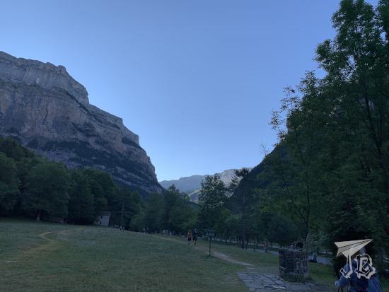
We reached the terminal with plenty of time (± 30 minutes) but recent problems with French air controllers going on strike, I was anything but calm. However, we took off on time and I just huddled off to nap. Arrival in Orly was early, and we did not taxi much, nor need buses. We just stepped off at the gate, and headed towards the Orlyval. We bought a Paris Visit card each, in order to be able to ride the public transport system as much as we needed for the weekend, and hopped on the shuttle. After a couple of transfers and a short walk, we arrived at the exhibition centre Paris Expo Porte de Versailles, where Paris Fan Festival took place.

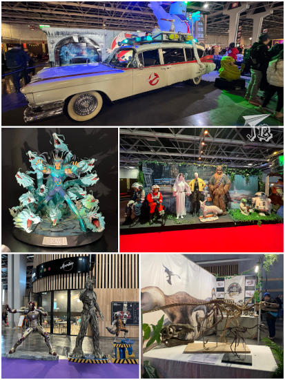
Paris Fan Festival is a yearly convention that focuses on everything geek / nerd / niche, whatever you want to call it: video games (and retro video games), Star Wars, TV series, Ghostbusters, manga, comics, K-pop, there’s something just for everyone. I think it’s a bit of what Japan Weekend aims to be, but openly. It felt a little like that Funko slogan “Everyone is a fan of something”.

My reason to be there was European comic, actually. Authors (and married couple) Stjepan Šejić and Linda Lukšić Šejić, whom I’ve been following for a few years now, were in attendance. Stjepan Šejić has worked for DC in works such as Aquaman, Harley Quinn, and Suicide Squad, but he has gone independent, focusing on his own content creation. So has Linda Šejić, who started off at Image Comics and currently works on her own web comics. I’m currently buying his works Sunstone, Fine Print and my favourite Death Vigil, and her Blood Stain and Punderworld, the latter based on the Greek myth of Hades and Persephone. I also have the Aquaman hardcover that compiles all of Stjepan’s issues, and the Batman-character self-conclusive Harleen.

Of course, I wore an appropriate “Velocirapture” T-shirt to the event. The goal was to get an issue of each collection signed, and maybe a commission and some merch. In the end, we could only get a commission from Linda – we almost got one from Stjepan too, but things did not work too well on that front. I hope to get one next time they’re reachable – I actually wanted to go and meet him a while back, but I was in the middle of a weekend in Cuenca back in 2017.

Paris Fan Festival: Stjepan Šejić and Linda Lukšić Šejić

My sibling and I wandered through Paris Fan Festival for a few hours. We had something to eat at a Paul’s bakery, which I had discovered in Toulouse, and whose prices were not stupidly inflated by being inside the convention. Unfortunately though, I had followed the instructions of the venue and I was not carrying any water, and just a small backpack. I could’ve completely ignored the rules though, just like… most everybody else did. I did learn a valiable lesson though – when travelling to conventions for people, you buy tickets for both days. Just in case.

One of the most interesting vendors at Paris Fan Festival was the Lyon Cinema and Miniature Museum Musée Cinéma et Miniature, which had brought many sci-fi props from their permanent exhibition. They had the tip of a pyramid, a hieroglyph stone and a mask from the original Stargate film, ), a compsognathus animatronic, and the velociraptor claws from the Jurassic Park saga (), Loki’s mask from The Mask, a xenomorph head from Alien, suits from one of the older Batman films and Armageddon, prosthetics from X-Men

Samples of the Lyon Cinema and Miniature Museum at the Paris Fan Festival

As every other niche convention, were tons shops with merchandise, books and comics, not all of them legal. They held an exhibit of figures and statuettes. There were also a number of conferences – pity that the one about Jurassic Park was in French, too. Also, I discovered that France has a lot of “replica” culture – there was an actual “Imperial Army” (Star Wars), someone who had customised a car into the Ectomobile from Ghostbusters (2016), even people impersonating Tolkien’s orcs… It goes a little beyond cosplay… Supposedly, there was someone walking around with a dragon, but we did not run into them.

Paris Fan Festival snippets

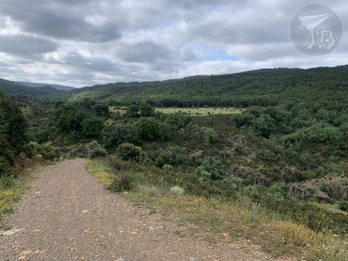
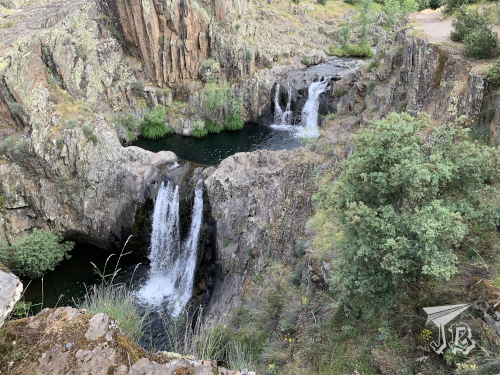
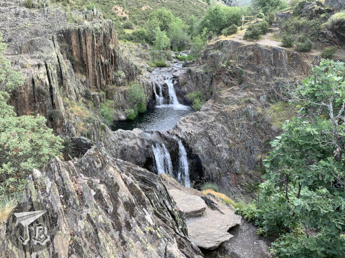
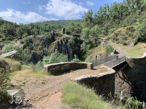
Eventually, we left the convention to find our way to the hotel and drop the luggage, since comics are heavy, and Paris is on high alert and most places won’t let you through with backpacks. We wasted some time finding the hotel as it was raining cats and dogs – and they were remodelling, so the outer signal was not there. After check-in, we headed out again, and when we reached our next destination, it had literally stopped selling tickets – it was one hour and four minutes to closing time, and the recommended time is one hour and five minutes, so sadly, we could not get in.

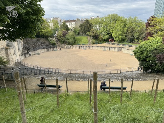
It was a bit disappointing, but we moved on towards Arènes de Lutèce. Lutetia (Lutèce) was the Latin name for Paris when it was part of the Roman Empire, and the amphitheatre is one of the most important remains from that period. Built during the first century CE, it would have seated 15,000 spectators. It was restored and open to the public at the end of the 19th century. Today, it is the centre of a park.

Lutetia Amphitheatre

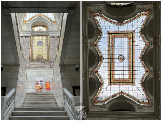
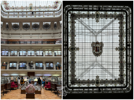
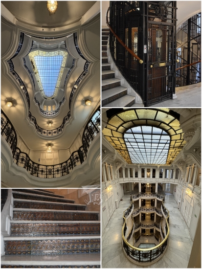
After that, we took the underground towards the high-end department store Galeries Lafayette Paris Haussmann. In 1894, two Parisian businessmen opened a shop that would eventually become the biggest department store chain in Europe. Through the following decades, the businessmen bought buildings around the shop in order to grow their emporium. In 1907, architect Georges Chedanne carried out the first main renovation in the Art Déco style, and Ferdinand Chanut completed it with a Neo-Byzantine dome, built in 1912. Today, the galleries focus heavily on luxury products, and not that we could afford any, but I wanted to see the dome.

When we arrived, we snooped around – it was packed, full with high-end tourists, mostly Asians. The brands selling their products were the most expensive ones – from Chanel to Cartier. As we were admiring the dome, we saw there was a glass walk hanging from the balcony on the htird floor. Of course, we had to investigate. It was around 17:30. We found the end of the queue, and saw that there was a QR to reserve a spot. I was able to book us in for 19:20 – surprising, considering it was the same day, and access is free – maybe it was a language barrier or something? I’m not going to complain.

There was a nearby gallery I also wanted to see, Passage du Havre, a typical Parisian shopping passage. It was less impressive than the Lafayette, but also surprisingly cosy – as my sibling put it “the other guys have Chanel, they’ve got Sephora”. It had some nice decoration and quite a different crowd. Furthermore, we had been up since 4:00, and ate quite early, so when we found a Pret a Manger, we decided to buy dinner there.

Passage Du Havre escalators

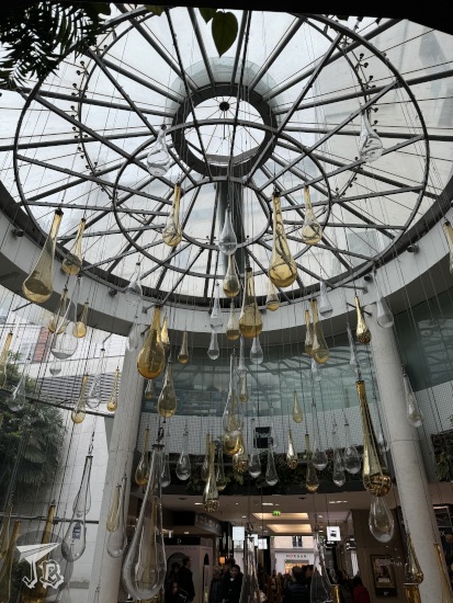
We went back to Galeries Lafayette for our “Glasswalk” experience, and it was really, really cool. The staff were also impressively friendly and we enjoyed ourselves immensely for the whole… five minutes of it. I really loved the dome.

Upper floor of the Galerie Lafayette

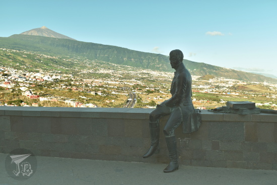
We finally headed off towards Napoleon’s tomb, the Dôme des Invalides in the complex Hôtel des Invalides. Hôtel des Invalids was originally commissioned by Louis XIV in 1670 as a hospital for disabled soldiers. The church-and-chapel complex was designed by Jules Hardouin-Mansart in several iterations from 1676 on. The complex is considered one of the most iconic examples of the French absolute monarchy Baroque style. When Napoleon’s remains were repatriated in 1840, a state funeral was held, and a mausoleum projected in the crypt under the Dome. Construction of the grave extended until 1861, when the former Emperor was finally entombed there.

We were going to see the light mapping event Aura Invalides, a spin off of sorts from the display in the Notre-Dame Basilica in Montreal (Canada). The show highlights the history, architecture and meaning of the monument through light and orchestral music. The event lasts about 45 minutes, and it comprises three parts: First Movement: Creation, which focuses on the architecture of the monument; Second Movement: Collective Memory, through which you get to wander, seeing different effects in the chapels; and finally Third Movement: Universal Elevation, more spiritual and ethereal.

Projections inside the Invalides church

Les Invalides church by night

Afterwards, we headed towards the hotel to have a shower and sleep.

28th April 2024: No plans, really

After a nice breakfast at our hotel, we tried our luck at the Paris Fan Festival again. We got our drawings from Linda Šejić, but Stjepan Šejić had brought all the wrong markers and was not doing any more commissions. I offered my own pen, just to test the waters, and it was unfortunate that he did not take the bait.

Oh, well. You can’t win all the time. Instead of wallowing in our bad luck, we decided to get going and do something cool. For me that meant the park known as Jardin des Plantes, to visit two sites of the French Natural History Museum Muséum national d’Histoire naturelle. The day had started weirdly, with my underground ticket not working, but my sibling’s doing so. A lady who did not seem to enjoy being stuck at work Sunday morning waved us through without exchanging it. As the ticket was still not working when we left Paris Expo, another employee exchanged it.

The first site we visited was the Great Gallery of Evolution, Grande Galerie de l’Évolution, the biggest site of the French Natural History Museum. It has four visitable levels – the upper balcony (third floor), focused on “Evolution of life”, the second floor “Impact of man in life”, and the first and ground floors that deal “Diversity of life” (terrestrial on the first, marine on the ground floor). The way it is arranged makes it, in my view, a companion to the Gallery of Compared Anatomy – (which I still like best, to be honest).

The collection finds its core in the disappeared Zoology Gallery, whose building dates back from 1877. Designed by architect Jules André, the interior was a cast-iron structure with a central nave and a skylight. Although the original project was never completed, the Galerie de Zoologie was inaugurated in 1889. It closed down in 1966 for restoration, although works were actually only carried out between 1991 and 1994. During this time, taxidermist also took care of about a thousand animals. Today, the gallery holds a cavalcade of savannah animals on the ground floor, and more conservative vitrines and glass cases on the upper floors. The museum still keeps the 19th century allure and entertaining aura – we did not go into any of the VR experiences, as they were sold out (and, you know, in French), so we did not see the more modern area of the museum.

Great Gallery of Evolution

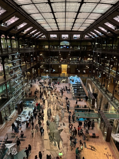
We started off on the third floor and made our way down to the ground level. There were a ton of taxidermy animals, collections of insects and shells, even a wool one, and some bizarre specimens such as a tiger attacking an elephant with a chair on top… To be honest, though, I think it is more of a regular zoology gallery, just arranged in a surprising way. I found the evolution angle better developed at Brussel’s Natural History Museum. The classical design is extremely cool, though, and it would have given a great feeling had it not for all the free-range kids wildly running around…

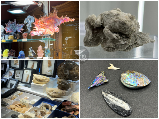
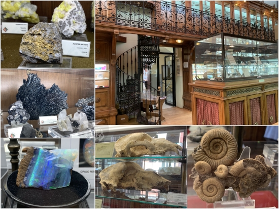
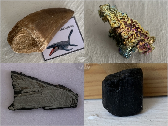
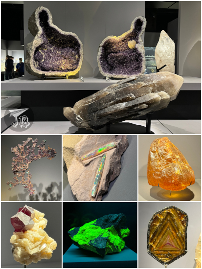
Afterwards, we headed off to the geology and mineralogy gallery, Galerie de Géologie et de Minéralogie, which had a really nice collection of gemstones, crystals and jewellery. And of course, fluorescent rocks which kept my attention for a very long while.

Mineral and geology gallery

It was almost lunchtime and we decided to head out towards a busier area to grab a bite. My Paris Visit ticket was not working again, and I exchanged it yet once more. I went through, but my sibling did not, so they had to wait in queue again to exchange that too. Apparently, I was keeping the tickets too close to my phone – even if it was the one without internet? I deemed my sibling responsible for the tickets from then on.

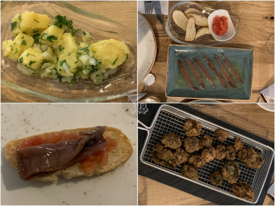
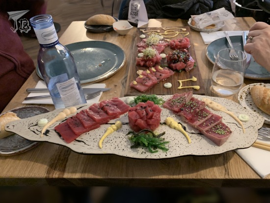
We stepped out at Palais Royal–Musée du Louvre, hoping there were places to eat, and we were right – there were a bunch of them along the street. The one that grabbed our attention was Café Brasserie Ragueneau, a small eatery close to the Louvre. There, I splurged on a Tartare de boeuf poêlé au foie gras (Pan-fried beef tartare with foie gras) just to be a snob. It was delicious. The foie gras version came slightly cooked, though the raw version would have been fantastic. Our waiters were extremely friendly too, and tolerated my poor French with a smile.

Pan-fried beef tartare with foie gras

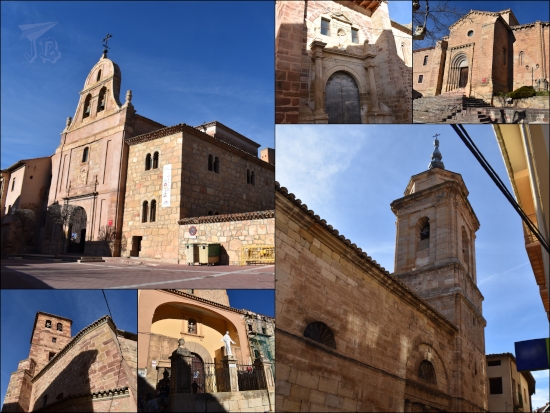
After lunch, we walked to the last place on my list for the trip – the church Église Saint-Germain l’Auxerrois de Paris, which mixes elements of Romanesque, Flamboyant Gothic, Rayonnant, and Renaissance styles, though the tower – my favourite – was only added in 1860 as part of Baron Haussmann’s plan to reconstruct the city. The base of the church dates from the 12th century, and during the 14th and 15th centuries it was decorated with a balustrade by Jean Gaussel, multiple sculptures, and gargoyles. The interior is lighter than usual gothic churches, and there is a monumental set of carved wooden seats for the royal family. There are multiple windows with stained glass, although not all of them are the original Medieval ones, since they were destroyed during the French Revolution and replaced in the 19th century.

Church of Saint-Germain l’Auxerrois

The Louvre was not selling same-day tickets, so our idea to spend a couple of hours there went bust. Then, we decided to walk towards Île de la Cité to check on the cathedral’s progress, as it is supposed to reopen this year, when reconstruction from the 2019 fire has been completed. I wanted to check something called Tunnel des Tuileries, but I misunderstood – I thought it crossed underneath the Seine to get to the Isle of France; apparently I mixed it with a pedestrian tunnel under the Thames – it turned out to be a place of modern art, and it did not feel too safe. Thus, we continued under the sun, and reached the flower market Marché aux Fleurs Reine Elizabeth II.

We found out that a sort of stage has been built for visitors to sit in front of Notre Dame, and we saw a lot of people taking pictures of the pictures on the wall, which was a bit weird. We sat for a while, but not long because there was a guy singing really badly at the square.

Notre Dame under reconstruction

We went on and saw the park Square René Viviani, where the oldest tree in Paris stands. Next to the park is the church Église Saint-Julien le Pauvre and close to Église Saint-Séverin. We could not enter any of them, so instead we decided to sit down to have a coffee – in my case a “detox smoothie” because the orange-and-carrot blend reminded me of one in Japan I really like.

We finally set off to collect our things, and this is when I usually say I got home without an incident. Not this time. The public-transport tickets worked fine to get to the airport, we bought dinner and settled to wait. There was nothing much too strange, we were late – forty, forty-five minutes? I’m not sure, but not an obscene amount of time – the crew announced connections over the PA system, I thought that was nice of them. When we landed… I had a moment that I did not know where we were, which is strange, because the terminal is pretty straight forward. It turns out that in order for the travellers who had connections to South America to make it, we had landed at the Satellite Terminal, not the main building! Which meant over thirty minutes of “commute” back to the parking lot… I had taken a leeway of around an hour and a half after landing to get out, but we barely made it!!

A nice weekend to break out the routine, a lot of comics signed, and a lovely piece of artwork were achieved. Unfortunately, I caught a stupid, stupid cold, my first since the whole Covid thing started, and my immune system freaked out. It seems it’s back to facemasks on planes for me.

9th March 2024: Minerals, fossils & trains (Madrid, Spain)

I might not be the most people-person ever, but if there is something that makes conventions extra fun, it is seeing attendees unapologetically geek out about what they love – in the case of Expominerales, that would be… rocks. Of course, this is an over-simplification. Expominerales is held yearly in the mine and energy engineering school Escuela Técnica Superior de Ingenieros de Minas y Energía (ETSIME) in Madrid. The year 2024 marks the 43rd edition of the event, which is considered one of the most important fairs in Spain in the topic of Earth Sciences – minerals, fossils, gems, and meteorites are widely available to the public. Aside from the small historical museum Museo Histórico-Minero Don Felipe de Borbón y Grecia, there were dozens of exhibitors with all kinds of items for sale, ranging from a few euro to several thousands. These year there were a few lectures, too, and coincidentally, the two of them I was most interested in happened on Saturday, one after the other.

I arrived at the ETSIME around 11:00, and I walked around the stands a couple of times. I have to say that I wanted everything, but I set a budget and I was able to stay around it, after shopping and lunch. At noon, I settled to listen to the lectures – one about the rehabilitation of an ancient gypsum mine in a hamlet called Hornillos de Cerrato, in the area of León. The other one versed about the uses of an already-rehabilitated one in the south of Spain, home to a huge geode. Both of them were pretty interesting, though the conference room was freezing. Someone had forgotten to turn on the heater there, it seemed…

Expominerales 2024 at ETSIME

After the two conferences, I had a last round to buy a last thing, so in the end I bought an iron-meteorite pendant, a fossilised shark tooth pendant, a plesiosaur tooth, and a soil sample of the K–T boundary. A plesiosaur was a marine reptile with flippers, a short tail and a long neck. The K–T boundary (now named the Cretaceous–Palaeogene (K–Pg) boundary) is the theoretical layer of iridium-rich black sand that was formed by the meteorite that caused the extinction of non-avian dinosaurs – and basically most life at the time, in one of the great world-wide extinctions in the history of Earth.

Shopping from Expominerales

At 14:30, I had a reservation for lunch at a Japanese franchise called Ramen Shifu. While I had originally been looking forward to trying the ramen (and I got my hopes pumped up when I read that they were Hakata ramen style), the noodles were rather disappointing. Fortunately, the okonomiyaki – Japanese pizza of sorts, made with a base of cabbage and topped with sauce and bonito flakes, was all right. On top of everything, paying was stupidly difficult because they did not have change.

Shifu Ramen ponzano - okonomiyaki and ramen

When I came out of the restaurant though, it was raining like crazy. I pulled out my umbrella and hopped towards the closest underground station, as my next destination was inside the metro system – one of the Underground’s museum network Museos de Metro de Madrid the collection of classic trains Estación de Chamartín: Exposición trenes históricos, inside the Chamartín stop. The exhibition displays four historical trains, restored from among the first ones that ran under the city, and some memorabilia. It was a bit underwhelming – more like false advertisement. I hoped I would be able to snoop inside the trains, since that was the photograph that opened the webpage, but unfortunately they were cordoned off. There was however a map with the works by Antonio Palacios in Madrid, which will become handy eventually.

Classical Train Exhibition Madrid

Afterwards, I just headed off towards the train station and got back home.

16th December 2023: A day out of ExpoGema (Madrid, Spain)

Since the mineral expo ExpoMinerales back in February was all cool and fun, I decided to attend its shinier (and unbeknownst to me, way more unaffordable) sibling, the gem expo ExpoGema, and make a day out of it. Thus, I headed out for Madrid on the 9:00 train with temperatures below zero – I was not made for winter. It was not much better when I arrived, but for once the train ride was uneventful, I actually made my connection, and it seems that after a chaotic year, the underground train tunnels are finally open. Everything going smoothly gave me some unexpected 45 minutes to wander around as the square Puerta del Sol slowly became fuller and fuller with people.

I had booked a guided visit through the company Madrid en Ruta, who has the exclusive concession to show the business centre Casa Comercial Palazuelo. Located in downtown Madrid, it was designed by architect Antonio Palacios. The promoter, Demetrio Palazuelo, bought the lot left behind by a fire, and commissioned the building with the goal of renting it out to shops and professionals – it was thus the first office building in Spain conceived as such, and not repurposed from a manor or an apartment building. Palacios drew inspiration from the Chicago School commercial architecture and used iron to stabilise the building, which allowed him for bright interiors using lots of glass. The office building was erected between 1919 and 1921, and the offices are still rented out today, with the only caveat that the beautiful interior translucent-glass doors have been painted white – to either protect privacy or hide the fact that today the house seems to be almost empty – at least according to the building’s own directory.

The exterior façade could be considered eclectic – the main frame tends to neoclassicism with huge glass windows framed in black iron. The interior tends towards Art Deco and modernism. The offices are distributed around a central indoor patio, with curved balconies that overlook it and lots of lights mainly due to the skylight. There are two classical lifts which are the original ones, in peartree wood. When we went up, I took the stairs, which have white treads, and the riser is made out dark green ceramics. I have seen these in other works by Antonio Palacios.. The interior, with the iron balustrades and its curvy design, was really cool, but I think it is really a pity they painted over the glass.

Interior of Casa Palazuelo

The visit started at 11:00. We spent the first fifteen minutes outside getting context, roughly half an hour inside, and the last twenty minutes on the roof of the building, waiting for the clock of the Puerta del Sol to strike 12:00, then we were ushered out. I really wish we could have wandered the house a little bit, even if we could not go into the offices. The ten euro we paid surely did not feel like we were paying customers, but more like we were sneaking around like unwanted guests – which we probably were anyway.

Puerta del Sol from the roof of Casa Palazuelo

I grabbed a quick snack then and headed off towards the engineering school Escuela Técnica Superior de Ingenieros de Minas y Energía (ETSIME) for the sixth edition of the gem fair ExpoGema. The fair itself was neat, but most everything was way above my budget range. I was there at the typical Spanish lunchtime, there were few people, and most were at the stands. Thus, I had the museum Museo Histórico-Minero Don Felipe de Borbón y Grecia almost completely to myself. I really like old-style museums, and this one has a huge amount of specimens, most of them are minerals, but there are also fossils and a collection of cave bear skulls and bones. I had decided not to book any guided visit or activity as none happened within the couple of hours of lunch downtime.

Geology Museum at Etsime

I bought an ammonite pendant, a small pyrite with almost perfect right angles, and another pendant made with a small meteorite from Campo del Cielo, along with a tiny extra piece. Campo del Cielo is an area in Argentina where four or five thousand years ago an iron meteorite fell. The meteorite shattered upon entering the atmosphere and, when it impacted the surface, the different created up to 26 craters. About 100 short tonnes of a fragmented iron meteorite have been recovered to date, and I now own around four grammes of it – yay me. I did not buy any precious stone though since the pretty shiny rocks were way out of my budget.

Expogema 2023

I left the ETSIME and I walked towards the square Plaza Pablo Ruiz Picasso, where there is a temporary art installation called El Regalo (The present) by Amigo&Amigo, a studio specialising in art installations. The artwork comprises a few arches that end in pads that can be stepped on – when they are, music sounds. The day was still bright, so the artwork was not shining, but a bunch of kids jumped on the pads to keep the music playing.

El Regalo artwork

Afterwards, I took a train and headed off towards central Madrid again. I had a reservation for an afternoon tea at NuBel, an “avant-garde gastronomy space” in the modern art museum Museo Reina Sofía. I had been drawn to the place due to the “freshly-baked scones” they advertised.

The experience was beyond disappointing. First, I had to wait to get seated, but then the person who checked me in forgot to notify that I was there – this is what I assume happened, I was literally told that “the kitchen had forgotten about me”. The set menu took 40 minutes to come out, and the scone was cold anyway, so not even freshly-made. I had got a decaf latte that was also cold when the food came.

The menu, 16€ as I don’t drink alcohol, consisted of: two mini-sandwiches – the two of them had been made from the same bread slice, so you can imagine the size, with some kind of mayonnaise filling which was not bad but rather unidentifiable; one shot-sized glass of (pre-made) gazpacho; one scone; a piece of red velvet cake; a piece of carrot cake; one chocolate brownie; a side of cheese cream, butter and jam; and in my case the already-stone cold decaf latte.

Nubel afternoon Tea

The scone was cold – so much for freshly-made, the only thing that had kept me waiting. Furthermore, the cheese cream, albeit nice, did not fit it like at all, so I had to use butter on it. I laughed to myself thinking about “the horror!” while I clutched my metaphorical pearls. The red velvet was probably the best, but in general the cakes were too sweet – good thing the menu included free tap water. Afterwards, I was comped another free decaf as an “apology for the delay”. However, when I tried to pay, more drama ensued. First the card-reading machine was not working, then they could not take cash because they were balancing the register, then they could bring the machine to the table. All in all, I spent almost hour and a half there – about five minutes waiting to be seated, forty minutes waiting for the tea set, and twenty minutes trying to pay. I’m sorry to say I did not tip, nor do I plan to ever come back.

I missed my train due to the paying delay, and I had to wait almost half an hour for another one. I hung out the Christmas market for a bit, and looked at the lights around Puerta de Atocha station. As it was cold, I walked in and went to check out the original train station, now turned botanical garden. I had never stopped to look at the iron ceiling, just at the plants – and the tortoises people used to dump there – but there had been an old photograph during the Casa Palazuelo visit that made me want to look at the building itself, and I recognised that old station in today’s building, with its wrung iron columns. Funny, how you can look at the same old things and recognise them.

11th June 2023: Cuevas del Cerro del Águila {WNW Spain, with a splash of Portugal, June 2023}

We had decided to split the way back, so we booked tickets for the natural cave known as Cuevas del Cerro del Águila. They are located in the mountain range Sierra de Gredos, quite literally in the middle of nowhere. They were discovered by accident in 1963, and have been open to the public since 1964.

The geological construction dates back 500 million years, from the time when the area was a dolomite-filled marine platform. When Spain emerged as dry land, rivers started flowing, dissolving part of the rocks, and created de underground halls. Mineral-saturated water dripping creates a wide variety of speleothems – stalactites, stalagmites, columns or stalagnates, flowstones…

Caves Cueva del Águila

Caves Cueva del Águila

It was a really cool thing to see – I’ve been to caves before but this one was the most impressing I’ve visited in a while.

Afterwards we just drove off back home for a late lunch, a nap, and getting ready for the work week.

9th June 2023: Arribes del Duero & Ciudad Rodrigo {WNW Spain, with a splash of Portugal, June 2023}

We set off from Zamora in order to drive up towards the Portuguese town of Miranda do Douro, though we were not due to reach the town itself. We were heading to the International Biological Station, which organises environmentally-friendly cruises up River Douro.

The drive was to take around one hour, and we stopped at the reservoir Embalse de Ricobayo, which has a dam and a hydroelectric central. We stumbled upon a nice little outlook above the reservoir to see both the dam and the meandering river. It was not long before we noticed the vultures – a kettle of Eurasian griffon vultures (Gyps fulvus), and even some solitary birds that showed off (or were trying to find breakfast, who knows?).

Meander and Dam of Ricobayo

We reached the International Biological Station Estación Biológica Internacional | Estação Biológica Internacional (EBI) in time to swap our 12:00 tickets for 11:00 tickets, and the little boat took off. The cruise runs up the area of River Douro Río Duero called Arribes del Duero, a gorge nor dissimilar to the Galician gorge of River Sil. It was an hour-long course where we got to see some more birds of prey, a few nests, lychens and local flora, but none of the wild otters that are supposed to swim on the river. The guide collected some water to observe under the microscope and show us copepods and water fleas. At the end of the boat ride, we saw the “emotional therapy otters” (Lutra lutra) that the EBI keeps at the entrance. Oh, and had a sip of Porto wine. I was not too keen on the whole thing though, despite the pretty landscapes.

Arribes del Duero

Otter playing in the water

We “boycotted” Miranda do Douro as the ascent road from the river to the town looked horrible and full of curves. Thus, we headed off to Ciudad Rodrigo, in the Spanish region of Salamanca. We had booked at the local Parador Parador de Ciudad Rodrigo, Castillo de Enrique II de Trastámara. It is a really cool building – a castle from the 14th century, commissioned by the King . The main feature of the building is the keep, which you cannot climb (technically you can, but you have to know that you need to ask beforehand), but you can walk around the walls to have a look at the skyline. In front of the Parador stands a pre-Roman sculpture of a verraco – a granite animal, maybe a pig or a boar, dating back from the Vettones (3rd century BCE – 1st century CE).

Parador of Ciudad Rodrigo

There was a mishap with our reservation, so instead of getting a three-person room, we got the doggy-friendly room. I’ve been long-supporting of pet-friendly travel, but this made me rethink my stance. The room did have a pull-out sofa bed, but the layout made it awkward to share it among three people. Furthermore, it smelt and there were a bunch of flies and fruit-flies at the windows. That was a bit of a bummer.

We went to walk around town and found the tourist office in the mansion called Palacio de los Águilas, a 16th century Renaissance building erected by the family in charge of the castle upkeep. It has two patios with arches, and an exhibition area about the role that the town had in the war against Napoleon’s armies in the 19th century.

Palacio de los Aguila

We wandered around the town for a little, but then it started pouring. Thus, we hurried towards the cathedral Catedral de Santa María de Ciudad Rodrigo. The original building dates back from the early 12th century, and it was in construction and reconstruction until the 18th century. The main building was finished in the 14th century, but the tower collapsed after the Lisbon Earthquake in 1755. One of the most important features of the cathedral is the Romanesque portico Pórtico del Perdón, similar to the one in the cathedral in Santiago de Compostela. The gothic cloister is really nice, and it holds frescoes from the Romanesque period.

Cathedral of Ciudad Rodrigo

Cloister in the Cathedral at Ciudad Rodrigo

By the time we finished, the storm was over. I climbed up the remains of the town’s defensive walls Adarve Juan Martín Zermeño.

Ciudad Rodrigo: wall

We ditched the chamberpot museum (yes, it is really a thing) and to end the day we walked around the town for a little to find the traditional buildings – the manors Casa de la Marquesa de Cartago and Palacio de los Miranda, the square Plaza del Buen Alcalde, the old army HQ Antiguo Cuartel de Artillería,–the churches Iglesia de Cerralbo and Capilla de la Venerable Orden Tercera, and the main square Plaza Mayor.

Ciudad Rodrigo typical buildings

7th April 2023: Monasterio de Piedra (Nuévalos, Spain)

There are many things to consider when visiting the so-called Monasterio de Piedra, a tourist complex in Nuévalos, in the area of Aragón. One of the most important ones is the weather – as most of the complex is outside. The second is probably people. Just the online bookings are 2,000 tickets in a day – and some more go on sale throughout the day as visitors leave, or it is calculated that they do. A third factor is getting there, because it is literally in the middle of nowhere. This year, Easter break has peaked at an almost 100% occupancy rate since it seems that Covid is dwindling down, and the weather is superb – these facts have implied crazy traffic, too.

I had been mulling the trip for a while, checking weather and traffic warnings, and considering all the driving around that would be take place. I thought that the 7th would be a good date for a day trip – fewer cars out within the break period, and I was busy on the 8th, the other calm day. When I finally decided that the 170-km-each-way drive was going to be worth it and safe as the traffic authority had not updated its warning on the late-afternoon of the 6th of April, there were around 30 left for the 7th, and it was already sold out for the 8th. I got worried about traffic again, decided to leave the tickets for later, and by the time I definitely made up my mind, the day had been sold out!

I was disappointed, but I noticed that some tickets had become available for the 8th when previously there had been none. Thus, I kept checking throughout the evening, and finally around 23:00, I was able to purchase the 2000th ticket for the complex. Good thing that while I was wondering whether to go or not, I had prepared a backpack with whatever I might need, because if I wanted to beat the crowds, I had to leave by 7:30.

I did, and I made it to the complex around 9:10, after driving on almost-empty roads. I had planed to park in the outer lot, but as I reached the area, there were a number of workers directing cars and I ended up in the inner area. All the visitors who were already there – maybe I was the 30th car or so – stepped out of their vehicles commenting “oh, I thought there would not be so many people so early”. I thought the same… I had no idea of what “many people” meant in this place yet.

The Monasterio de Piedra complex has two distinct parts – the historical garden Parque-Jardín Histórico del Monasterio de Piedra and the monastery-turned-hotel. I decided to visit the park first, which would later be proven a good idea.

Río Piedra is mainly a pluvial-regime river (a fancy term to say that its flow depends on rain), also fed by various underground springs. The water has a high concentration of calcium carbonate, which for centuries has been key in creating the landscape that characterises the park, with a large number of waterfalls and caves – calcium carbonate dissolves and precipitates depending on how much water the river carries at any given time. Along the fertile soil from the river banks, the precipitates feed a very green landscape which in turns yields to a rich and varied fauna that lives there.

The park was established as a Romantic garden during the 19th century by Juan Federico Muntadas when he inherited the area. He also built the first Spanish fish farm there to breed river trouts. The garden is organised in two trails, a main one and an “extra” one – I decided to take the main trail, which runs around 5 km. The park prohibits food inside, but it does not really enforce it. I took a bottle of water, and an energy bar just in case, without the intention to eat it unless it was an emergency.

I walked in, got my print-at-home ticket scanned, and I was surprised that a few steps in, someone was holding an owl for people to take pictures with it. At 9:00. That was bizarre – I knew that the park used to hold birds of prey shows, but I thought it was a thing of the past. I got to my first intersection, and a park employee directed me towards the route. I was a bit disoriented for a minute or two, and I later realised that they were flushing the first visitors towards the big bottleneck area in order to try to control people, capacity, and waiting times. In this garden, the amount of people you run into can indeed make or break your experience – and I am happy to say that I made the right choices most of the time. The biggest problem I ran into were families with small children being loud, which was annoying but bearable.

Because of the redirection, I started off at what would have been number 16 on the route – the most famous waterfall, called the “ponytail”, Cascada de la Cola de Caballo. From there, you walk into one of the karstic caves (Gruta Iris) and pass under another waterfall, which even creates a small underground lake. It was cool, but I was really not prepared for how splashy it was! I continued off, I saw the and walked around a backwater called “mirror lake” Lago del Espejo for obvious reasons – it reflects absolutely everything. Although the route is only 5 km, it goes through areas that feel and look completely different, and it feels much, much longer without being tiring.

Monasterio de Piedra garden - waterfalls, karstic caves and the underground lake. Everything looks green with the vegetation and reddish with the karst deposits.

A 15-metre waterall, water splashing, flows into a river. The land around it is reddish-grey

A reddish hill perfectly reflects on a lake.

As I “finished” the route, I got to the intersection where the bottleneck is created and I saw all the people waiting – hundreds, probably. That was unexpected, because it had not felt that it was so crowded – it turned out, arriving early had been a great idea. The amount of people waiting was shocking, but understandable as most of the cave passages are only wide enough for one person – now I understood the reviews that claimed hours to see the waterfall and the cave.

I got a bit disoriented at this point – as I said, the route feels long since the landscape is so varied. However, instead of going for the exit, I decided to continue exploring a bit more – that is how I arrived at the lower numbers of the route again – number four, that was a bit more on the crowded side. I did the first part of the route, climbing up the hill slopes to see a dozen or so more waterfalls. Then had to backtrack again, until I finally saw everything that there was to see, even if in a strange order (on the map: sixteen to end, four to fifteen, then three to one. Not confusing at all, I know).

Monasterio de Piedra garden - fountain, and waterfalls and a cave. Everything looks green with the vegetation and reddish with the karst deposits.

Unfortunately, loud people scared most of the wildlife away, so aside from a few fish, there was nothing around in that respect. There were dogs around, but well-trained, so they did not cause a problem. The area is really nice, the waterfalls and caves are beautiful, but I can see how the number of people you visit it with might make it a good or bad experience. I am sure that I would have quit had I needed to wait hours to cross a cave and see one of the waterfalls.

When I left, there was a huge queue to get a picture with the owl. Furthermore, there were several huts with more birds of prey or other animals, and the pictures were sold at the exit. I’m not sure I approve of that, no matter how trained the animals are – there actually used to be exhibitions with the birds of prey, which is not happening these days. After I left the historical garden, I went into the former monastery. Today, most of the building has been turned into a hotel, but part of the historical site can be visited.

The monastery Monasterio de Piedra was established in the 12th century by Cistercian monks sponsored by king Alfonso II of Aragón. The building was erected in the years when Romanesque was turning into Gothic, so it mixes both styles along with some extra Baroque. Between the late 18th century and the early 20th century, the Spanish government carried out several programs to seize and sale property deemed “unproductive” – mostly belonging to religious orders and municipalities. These properties were auctioned to convert them into cash so the government could pay off its debt. The whole process is known as the Spanish confiscation (desamortizaciones).

In the 19th century, Monasterio de Piedra was confiscated. Everything it contained was auctioned in the 1840s and 1850s. In 1843, the buildings were also sold and acquired by the Muntadas family. It was soon afterwards that Juan Federico Muntadas became the owner. He turned the orchards into the now historical garden, and the convent itself into a hotel and… what today would be called a “wellness spa”. He also established the fish farm.

I would have really liked to stay at the hotel, but it’s a bit on the expensive side and there is really nothing else around, so you have to pay for meals on top of the stay. But it would have been cool to wander the monastery building at night. Not being a hotel guest, the ticket includes access to the cloister and the old church. Some rooms around the cloister have been dedicated to host exhibits about regional or historical products and items: carriages, wine, and even chocolate – the monastery was reportedly pioneer in the preparation of chocolate in Spain. The cloister itself has a few chapels, the early-Gothic chapter house with decorated columns and ambience music, and a small garden-like centre. You can also visit a monk’s cell, and there are mannequins spread through the different rooms – startling if you are not paying attention and suddenly see one.

I am not a wine person, so the museum on the topic did not impress me much despite having a bunch of traditional wine-making artefacts. The chocolate exhibit was just a succession of panels with pictures, and thus a bit underwhelming. Within the monastery, what I enjoyed the most was the architecture itself I guess. I loved the cloister and the chapter house most.

I also visited the adjacent ruined church. Like the cloister, it’s early Gothic. It has a Baroque chapel to the side which keeps the wall paintings. Although most of the ceiling is gone, the church still looks pretty – then again we all know that I like the architectural style anyway. It’s nice how the building is somehow ruined but at the same time it’s not, as it has been restored and preserved. However, underneath the altar, there is a small crypt, where a small window has been made to peer at someone’s bones – that was… huh… unnecessary. The nave is now open to the sky and covered with grass, all the figures have gone, and only one of the sides holds a few architectonic remains and capitals.

Inside the monastery - the cloister and the ruined gothic church

I left the inner area and I walked around the outside of the building – what has become the picnic area since you can’t eat inside the garden. Once I left that behind, the area was deserted. I reached the former main square, where the Baroque façade of the monastery still stands. I walked a bit further and found the walls that used to enclose the area, along with a small tower that is called the keep, but it looks more like a defensive tower.

The baroque main entrance to the monastery

Finally, I checked out the gift shop, bought a book and some chocolate. I headed back a bit after 13:00, but instead of driving directly home, I made a stop at a couple of viewpoints over the reservoir Embalse La Tranquera. On the way out, I had crossed several tunnels and seen viewpoints, so since I had time and I was not hungry yet, I decided to snoop around. After a while, I just drove back – though I might just have made a stop for a late fast food lunch, because guilty pleasures happen sometimes. And by 15:00 I was hungry indeed.

A reservoir with turquoise water, nestled in a reddish gorge

11th March 2023: Rocks from the land and fish from the sea (Madrid, Spain)

Back in 2018, when going to Madrid’s Geomineral Museum (Museo Geominero), I stumbled upon an event in the Mining Engineering University – something called Expominerales. At the time, I did not have time to explore it, and only later did I realise what I had missed – an international fair for the trade of minerals, rocks and fossils. I made a mental note to check the event out the following year, but something came up and I completely forgot about the whole thing. In 2020 the pandemic struck, and finally in 2023, almost five years to the day, I went back to this event held in Madrid.

Expominerales is held yearly at the working engineering school Escuela Técnica Superior de Ingenieros de Minas y Energía (ETSIME), which offers the bachelor’s degree in Mining Engineering, and the one in Energy Engineering (whatever this last one is). The first weekend of every month, the school organises a “mineral-world flea market”, and the second weekend of March, it hosts an international mineral, gem and fossil fair, with shopping stands and different workshops and activities. After a few cancellations due to Covid, it returned in 2022 and it’s back to its former glory in 2023 – Expominerales XLII, the 42th edition of the fair.

The ETSIME in Madrid. Pink-and-white building from the 19th century, accessible through stairs, with flags hanging over the door

Mining Engineering became a formal education path in Spain in 1777, originally in the town of Almadén, a mercury hub. The school was moved to Madrid in 1835 and a two-building campus was ordered. The historical building in the ETSIME (M1) was designed by architect Ricardo Velázquez Bosco, and decorated by ceramist Daniel Zuloaga between 1884 and 1893. The second building (M2) was damaged during the Civil War, and has suffered several modifications to accommodate classrooms and laboratories. The premises also include a reproduction of a mine, Mina Museo Marcelo Jorissen, however this one is closed for renovation – a lot of that seems to be going on around the university, since part of the decorations of the buildings are also covered.

The M1 historical building has a central cloister with an ironwork colonnade. The building is rectangular, and on the short sides there are two symmetrical wards. One holds the historical mining museum, the other one the historical library. The central cloister is the main area where Expominerales is held, on the ground and first floor. On Saturday, the exhibit opened at 10:00, and we were there a bit later in order to sign up for the first guided visit at 11:00 (3€) – we wanted to take it so we had access to several rooms that would otherwise be closed to us. The idea was being there before families with kids started arriving and the activities became overcrowded – it turned out in the end that most the activities were indeed organised for children, so it did not really make a difference. Furthermore, the visit we feared full only had 6 attendees.

We had one hour before the guided visit that we spent looking at the stands on the ground floor on the M1 building. The guide was a student who might have been partying the previous night, because he sounded a little out of it – forgetting info and words, even things related to his own degree.

First, we went to see the mineral collection, the origin of the historical museum in the M1 building, Museo Histórico-Minero Don Felipe de Borbón y Grecia. The mineral collection was started in 1831, and throughout the years it was increased with new minerals donated by different institutions. It was later expanded to cover palaeontology and historical artefacts related to mining and other earth sciences. Though a lot of the displays are scattered throughout he building, the original museum dates from the 19th century, and it has four sections: the mineral collection, the fossil collection, the cave bear collection and the mining archaeology section, totalling over 10,000 items.

The historical mining museum at ETSIME Madrid. It is a large ward with cedar wood shelves from floor to ceiling, filled with rocks and fossils. The picture also shows some close-ups of rocks, two cave bear skulls, and a cluster of fossilised snail-like animals

Today, the museum is named after King Felipe VI, who visited the museum in the late 1980s after the university reached out to him to propose the name. The then prince came to visit then, and the name “the king’s stairs” was given to the set of side stairs he used – Escaleras del Rey.

We also visited the small hall where candidates read their theses, a little hall with spectacular ceramic tiles by Zuloaga, and finally the historical library, with obsolete but cool volumes. The library also dates back from the 19th century, with the walls covered in wooden shelves, with a small metal staircase to access the upper balcony. Unfortunately both this one and the one in the museum were cordoned off.

Library in ETSIME. It is a large room with cedar wood shelves from floor to ceiling, and a spiral staircase.

The visit ended at the lecture hall on building M2, one of the few remaining areas of the original design. It is a marble room with wooden benches and decorated windows that represent the original subjects taught to Mining Engineers. After we were left off, we sat down at the cafeteria for a drink.

Lecture hall in ETSIME (Madrid). It's a marble room, rather dark, with smoked windows representing different subjects of the Mining Engineering Degree

We recharged batteries, and then we had a look at the stands on the first floor of the M1 building, alongside the collection of apparatus that they had. Afterwards, we decided to separate in order to do shopping. Expominerales hosted over 30 stands, national and international.

Expominerales. A view of the ETSIME cloister from the second floor, showing different stands and lots of people peering curiously

I, being the nerd that I am, got myself a tiny slice of iron meteorite (from Geoterra Minerals), a mosasaur fossilised tooth (from Carlos Hammann, who also had amazing megalodon teeth that I will never be able to afford), a decent-sized of recrystallised bismuth (from Rossell Minerals), and a small piece of black tourmaline (from The MineralShop) – all for 51€.

Collage: a fossilised tooth, a bit of mineral in metallic colours, a slice of meteorite with silver orthogonal markings, and a bit of shiny black rock

When we met again, it was a bit past 13:30. There were too many people by then – families had started arriving, so we decided to leave. We had booked at a nearby restaurant for lunch, and they did not mind accommodating us a little earlier. The restaurant, called DeAtún Ponzano specialises in tuna dishes – particularly Atlantic bluefin tuna (Thunnus thynnus), sustainably caught in the Straight of Gibraltar.

Before overfishing was even a thing, Phoenicians settled in the south-west of Spain somewhere between the 9th and 7th centuries BCE – the city of Cádiz, credited as being the longest-standing city in Europe, may have been the first port. The Phoenicians observed that the bluefin tuna migrated from the Atlantic to the Mediterranean every year around the same dates, and later they came back to the ocean. These guys came up with a very simple technique – that was later developed further by the Romans and perfected in the Islamic period: the almadraba.

An almadraba is a portable but complex net which is lowered for the migration period. The bigger fish are funnelled into a box-like construction, and the smaller ones swim right through it. Once the almadraba is full, a number of fishing boats lift it in a process called levantada (raising). Expert fishermen walk onto the nets, discard any small specimen that might have been trapped, and choose the tuna that will be sold, generally individuals heavier than 200 kg.

Since the fish are selected on a case by case basis, the amount of both the catch and by-catch is small in comparison to other fishing methods. Both the seasonality and craftsmanship of the whole process make it much more sustainable than others – of course, this also causes fewer pieces in the market, which in turn increases the price. Furthermore, all the fish are wild, hand-picked, and only bled out when they are loaded onto the ship. Thus, the quality is extremely high. Another factor that makes almadraba-caught tuna more expensive is the fact that walking onto the levantada is dangerous. Fishermen have been seriously hurt by struggling tuna, as some of the fish might weigh up to 500 kg.

Working almost exclusively high-quality tuna means that DeAtún is not a restaurant on the cheap side of things. I’ve actually traced down their tuna provider and the prices are rather cost-adjusted for almadraba-caught tuna. There’s another thing to consider, too, which is that the Spanish law forces restaurants to freeze fish that is going to be served either raw or quasi-raw, at least for 24 hours at a temperature under -20 ºC – this is done to destroy a fish parasite called Anisakis, which can cause stomach distress and serious allergic reactions. Apparently, the perfect temperature to keep the tuna properties is -60 ºC. So yay Anisakis-safe almadraba-caught tuna all year round (though it’s true that the freezing law makes it impossible to eat fresh tuna raw).

We got a welcome tapa of boiled potatoes with olive oil and herbs (“papas aliñás”), a favourite from southwestern of Spain, the same area where the almadraba tuna are caught. We shared some European anchovies (Engraulis encrasicolus) “anchoas del Cantábrico” with tomato and toasted bread. These anchovies are salted for at least six months, cleaned, and stored in olive oil. They have a strong flavour, and are not everyone’s cup of tea, but I adore them. We also shared a portion of “ortiguillas” (Mediterranean snakelocks sea anemone Anemonia sulcata, battered and fried), also typical of the south-west – I’ve never been much of a fan though.

Lunch at DeAtún. Collage with a potato salad, anchovies and battered seafood balls

Finally, as my tuna preference is raw, I was wondering whether I wanted sashimi or tartar. In the end, I decided to try a combo (“trio DeAtún”): tuna sashimi (slices), tuna tartar (dice) and tuna tataki (heat-sealed slices), with a side taste of different sauce emulsions – wasabi, kimchi and curry. The tuna cuts used for these preparations (descargamento and tarantelo) would be the otoro or toro Japanese cuts, which are appropriate for raw preparations – technically the best ones, fatty or very fatty meat. I don’t love tataki, thus my original reticence to try this combo, but it was good. My favourite bit was the sashimi though, the tartar was missing a bit of spice.

I was offered chopsticks to eat the dish, and I accepted – easier to handle the fish. That apparently made the maître think that I had been the one choosing the restaurant, because in his words I “seemed to be an expert, chopsticks and all”. That was hilarious – I mean, why offer chopsticks if you don’t expect them to be accepted? For the record, although I booked the table, I did not choose the restaurant – it would have been a little on the “too fancy” side for me. The truth is, there were a bunch of very-elaborated dishes that we decided to give a miss, and we went for the raw tuna.

Lunch at DeAtún. A plate with three tuna cuts. The centre is round, and rose-like, and the sides are extended on a line. The fish is uncooked and it looks dark red. There's a similar dish in the background, with more cuts

Desserts were okay, but not the reason we had chosen this place. The point was eating tuna – raw tuna in my case – and the restaurant delivered. I was however amused by tables around us refusing the raw options even when the chef himself came out to greet them and recommend the dishes (someone over there must have been an acquittance, I don’t really know). Finally, we set back home to compare treasures and plot going back to Expominerales in its 2024 edition – at a time where we can snatch some discounted rocks.

13th September 2022: Wadi Rum (and the bus) {Jordan, September 2022}

I had a boiled egg, potato hash-browns and coffee breakfast because my body was craving salt, I guess. Then we set off on the bus, where we ended up spending around seven hours (the 412 km are supposed to be done in 5 hours and a half, but that does not take into account bad traffic). Urgh. Our first stop was a viewpoint over the whole canyon area.

Wadi Musa valley panorama, showing the deep gorge from above

The second stop was a souvenir shop that had probably somehow bribed our guide or driver for it. None of us even bought anything, but we were forced to be there for about half an hour before we could continue to the only organised activity for the day – a two-hour jeep tour throughout the Natural Reserve and Unesco World Heritage Site of Wadi Rum | Wādī Ramm [وادي رم]. It is the largest wadi “valley”, created by alluvial fans and wind deposits, rather than the idea of a river bed. They are often found in deserts.

During the tour in Wadi Rum Reserve [محمية وادي رم] we drove through the desert and stopped at some rock formations that had built a gigantic dune. Wadi Rum used to be a granite and sandstone rocky formation. Thousands of years worth of wind eroded the sandstone back to sand, forming and shaping the desert dunes. Huge granite structures still stand, such as the Seven Pillars of Wisdom [عمدة الحكمة السبعة], just at the beginning of the route. One of the stops is the tourist-named Big Red Sand Dune, which you can climb for kicks, giggles and some nice views of the landscape.

Driving into Wadi Rum. The roof of the jeep is visible, along with a rock formation in the background. Between us and the rock formation there is the other jeep, causing a dust cloud

Back of a dune we had to climb, and the rock + sand landscape that could be seen from the top. Wind erosion marks have created soft ridges. The rocks are red-grey and the sand is rose-gold

Then we drove off to see some petroglyphs, and were offered dromedary rides. These petroglyphs, depicting early humans and their cattle – bovines and dromedaries – are the reason for the Heritage status.

A rock wall with some dromedaries in the foreground + a close up of the petroglyphs engraved in the rock, also showing dromedaries (by JBinnacle)

Finally we were shown a Bedouin tent at the feet of the Lawrence Canyon, a beautiful rock formation with faces of Jordan monarchs. Unfortunately, we did not get to see any onyx or fennec foxes, but I did see a small lizard. The Bedouins treated us to a cup of tea, but then we had to tip the driver about 10€…

Lawrence Canyon, a deep cut in the rock filled with sand at the bottom + details of engraved faces and Arab script, a lizard and a bit of tea, along with a traditional Bedouin coffee maker

Afterwards, we started off our trip back northwards back to Amman | ʻAmmān [عَمَّان]. Though the trip is supposed to take about 4 hours, it was way more than that, and we did not arrive at the hotel until way past 18:00. We went through the security checks and ended up learning that we could not travel between floors, so we could not go to the others’ rooms using the lifts, and the stairs were blocked… Well, at least we had… views?

A view of Amman skyline in the dark

After we managed to regroup, we had dinner and decided to try to check in online for the flight next day’s flight – and I was successful. Apparently, the airline only cared about us filling in our Covid certificate to enter Jordan, we were on our own for the way back.

30th May 2022: The Slopes of Mount Teide {Tenerife, birthday 2022}

Due to the amount of near-misses, I had started thinking about this as the luckiest unlucky trip in a long time. Unfortunately, this was the day the luck ran out. As I woke up and turned on the phone I received the notification that the cable-car to go up Mount Teide was closed due to bad weather, which was a bit of a blow. I mean, I was in the middle of the natural park, without anything to do within a couple of hours by car as the hiking trails are closed on Monday mornings as it is then when the mouflon population is controlled – using rifles. I did not want to end up shot.

If you consider that the island Tenerife is one big volcano, Mount Teide is the most famous eruptive fissure. Considering it an independent item, it is a stratovolcano. The cone stands around 7500 metres from the sea floor, with an emerged 3715 m above sea level. Its base is located on a previous crater called Las Cañadas. Mount Teide last erupted in 1909, so it is still considered an active volcano, and it hosts a bunch of towns on its slopes, that might get obliterated in an eruption. Aside from being a National Park, the area is a Unesco World Heritage Site.

Historically, an eruption was reported by Christopher Columbus in 1492. Most recent eruptions happened in 2805, 1798 and 1909. Looking back, Mount Teide formed around 160,000 years ago, after the collapse of Las Cañadas. The last summit eruption happened in the 9th century, which caused the black lava blocks that seem to run down the slopes.

The whole point of my being there was going up the mountain, so I resolved to try and do that. I knew there was little chance I could make it to the top even with the access permission, but I would try. I decided to gamble the track Sendero de Montaña Blanca, which is the most typical one. For this, I had a good breakfast and started walking around 9:45 am. The track runs 8 km and starts at an altitude from 2348 m. If you have the permission, you can access the track Sendero de Telesforo Bravo that peaks the volcano at 3718 metres.

A stone and tile marker, with a map of the trail.

The first part of the morning, I spent on Montaña Blanca. I hiked around 3 km upwards in an hour or so. A park ranger told me that the bad weather was actually strong winds and to be careful. I’d never hiked with wind, so I decided that I would not do anything stupid. As I walked, I went by the accretion balls affectionately called “Teide Eggs” Huevos del Teide.

Collage: The Montaña Blanca trail. The landscape is desertic, reddish and brown, and there is barely any vegetation. When turning back, the sea peeks in the distance, and when looking up there are black rocks from an eruption.

Eventually, I reached the actual foot of Mount Teide, and this is when things got hard – and spectacular. The slope became much steeper and the wind made it hard to move forward. I walked between the two dark petrified lava flows, and could see Montaña Blanca and the Atlantic Ocean beneath.

View from the slope of Teide. Montaña Blanca is underneath, in red-gold. To the sides, the black and dark grey rocks trailing the old lava flows

I reached Refugio de Altavista at 3260 m around 14:00. At this point I was two kilometres away from the next station and 650 m away from the crater. Unfortunately, the elevation was still around 500 m. At this point the wind was very strong and shortly after the refuge I saw an area of the slope I knew I could climb up… but I knew I wouldn’t climb down with such strong wind, not safely. So I realised I had to turn back, even if that meant I wouldn’t see the peak, much less reach it. However, it was the sane thing to do.

Standing in the middle of the two solidified coladas - looking down there are black and grey rocks, and the sea in the horizon. Looking up, only more rocks.

It took me two and a half hours to hike down, and I made it back at the Parador around 17:30. I had a shower and I felt tired, though not as sore as I imagined. For dinner, I tried some local speciality “wrinkled potatoes” papas arrugadas, which are boiled in saltwater, and they are so high-class that can be eaten without being peeled. They come with some dips, a bit too spicy for my taste, but they were delicious.

Small voiled potatoes and three small bowls of sauces. The potatoes are unpeeled and they look wrinkled.

I was a bit bummed that I did not manage to reach the crater, but I think I did a good job, almost 1000 metres up and down. I guess it just meant I had to go back at some point…

29th May 2022: La Orotava, Icod de los Vinos & Parque Nacional del Teide {Tenerife, birthday 2022}

I got up rather early in the morning (especially considering that the Canary Islands are an hour behind my usual time zone) and I was surprised at how many people there were already on the streets of Santa Cruz de Tenerife before 8:30 on a Sunday morning. I drove out of the town and headed north-west, where I came across my first stop – a viewpoint of Mount Teide called Mirador de Humboldt honouring the German explorer from the late 18th century (though I kept thinking that there was a missing penguin opportunity there). The viewpoint overlooks the ocean and Mount Teide, which Humboldt climbed in 1799.

Mount Teide, a volcano, looms in the background. The top is bare and barren, but the slopes look green and fertile, with plantations and some villages. In the foreground, there is a bronze sculpture of Alexander Humbolt, sitting on the low wall of the lookout, and looking to the side.

I continued driving towards La Orotava, the municipality which Mount Teide actually belongs to. After parking the car, I walked towards the historical centre and ended up at the square Plaza de la Constitución, which stands next to the church Iglesia de San Agustín. Mount Teide loomed over the streets, ready to celebrate Pentecost Sunday. And guess what? The main church is called… Parroquia Matriz de Nuestra Señora de la Concepción. The initial hermit church was built in the 15th century, and it was completely rebuilt in the Baroque style throughout the 18th century, though the interior was remade in the 19th century and there was yet another renovation in the 20th century. It is considered the most important building of the Canarian Baroque.

A collage of La Orotava. The buildings are built with white plaster and black volcanic rock. Mount Teide peeks from the background.

The most representative construction in La Orotava is the “house of balconies” Casa de los Balcones. The house was built in the 17th century. The façade shows a front-long balcony on the third floor, and five smaller balconies on the second, all of them made from dark teak wood. The interior holds a museum, but I decided to give that a miss because I reached there at the same time as a very disorganised group of forty or fifty people who were going in at the time.

A colonial house. It is built in white brink. It has three floors. On the ground, there are brown windows. On the first floor, five balconies, with decorated ironwork. On the second floor, a long balcony or gallery in dark wood.

Instead, I went back to the car and drove towards Icod de los Vinos. There, my first stop was the butterfly house Mariposario del Drago, since the ethnographical museum Museo del Guanche is closed.

A collage showing colourful butterflies - red, orange, blue, black, black and white. One of them is chilling on the shell of a turtle, and another one is caught mid-flight. Most are on flowers and plants.

The butterfly house stands next to a botanical park Parque del Drago built around the symbol of the town – and maybe the whole island – the Drago Milenario. This is the largest and oldest specimen of Canary Islands dragon tree or drago (Dracaena draco). Folklore says that it is a thousand years old, hence the name “the thousand-year-old dragon tree”, though in reality, it is probably around 600 years.

The dragon-blood tree. It has a knotted grey trunk and bony branches. Around it there are bright-green palm and laurel trees

The park, built around the drago, holds local species trying to reproduce the local biotopes with height, there is also a small volcanic cave. It was here where where I managed to catch my first glance at the local fauna – two of the endemic lizards (though not as big as the one I had seen in the museum): lagarto tizón (Gallotia galloti) or tizon lizard, a blue-spotted male and a brown-striped female.

Two lizards. One camouflages on the grey and brown ground. The other on has a brown tail, but the body is black and bright blue

Then I went back to the car to climb up a crazy slope until I reached the visitors’ centre of the lava tube Cueva del viento. A lava tube is a “cave” formed the flowing lava of a volcano. As the outer part solidifies, the inner core continues flowing until it empties the tube. The guided visit is the only way you can enter the tube, so I had reserved that a few weeks earlier.

The visit started with a small introduction in the visitor’s centre, with a lot of “gotcha” questions on the guide’s part. I tried really, really hard not to be a smartarse, but I did sit down on the floor at a point because I did not feel like standing around for twenty minutes. The important information we received was that there were two types of lava that had formed the island of Tenerife: pahoehoe and block lava.

Then we took the centre’s vehicles to the outer area of the cave, where we could see the solidified lava, now turned into stone. Pahoehoe lava is basaltic, it flows slowly, and it is the responsible for creating the tubes. As it flows and solidifies, it creates undulations and wrinkles. On top of it, only small trees and bushes can grow.

Old Pahoehoe lava trails. The rock looks wrinkled or similar to pillows.

Block lava is more acidic, with a higher silica contents, it flows less and creates “blocks” as it solidifies. Pines can be found growing on top.

Pines around an old colada, which seems rocky and broken.

The cave itself was very cool. Unfortunately, there were a couple of families with kids and grandparents, all trying to be braver than the next – and thus acted loud and boisterous. More interesting information – mummified guanche aboriginals had been found in the cave, along with remains of a giant rat and lizard that were the ones reproduced in the Museo de Ciencia y Antropología de Tenerife. It is one of the biggest lava tubes in the world, with up to three levels and maybe 18 km of tunnels, though only a short walk can be had.

Inside the lava tube. It looks alien, like the rock is going to start dripping any second

Back in the parking lot, I had a snack and headed off towards the Parador de las Cañadas del Teide, where I had booked my next couple of nights. On the way, I went through several amazing volcanic landscapes that I could not photograph as I was driving. However, I did stop at several lookouts throughout the Parque Nacional del Teide.

Mirador de Samara.

Pines growing up on the dusty remains of a lava flow. In the background, there are three mountains - three craters of the same volcano

Mirador de las Narices del Teide, which shows the collapse on the mountain during the last known eruption.

A view of the black collapse of lava from the last eruption. Everything is barren, brown and grey, except for a black spillage coming down ominously. The sky is blue in the background, which makes the whole thing look even more bizarre.

Mirador Zapato de la Reina.

The top of Teide. This is the point where vegetation has become scarce, with low bushes, that creep up the slope. The summit looks naked.

Finally, I arrived in the area of Las Cañadas del Teide or Las Siete Cañadas where the Parador de las Cañadas del Teide stands. I was lucky that the season was good to see the flowering bugloss Echium wildpretii (tajinaste in Spanish), an endemic flora species mostly found on the Teide slopes. After checking in I wandered around the different tracks and paths – Cañada Blanca, Roques de García and Mirador de la Ruleta, which show the different stages of various volcanic eruptions.

Mount Teide rises in the background. It looks wrinkled due to the different eruptions. At its foot, a low building, looking completely out of place. In the foreground, small bushes in grey and green.

Collage: Different rocks and structures created by lava and erosion, the rocks are reddish or grey, and they have weird shapes. The tajinaste is a tall bush, with tiny red flowers, it stands about 1m above the rest of the plants.

I turned in early, and I had booked my dinner in the Parador both nights I’d be sleeping there, so that was an easy one. The staff made it a little awkward though, even if I was not the only solo traveller around. After dinner, I tried to get some pictures of the night sky, but I was unsuccessful.

1st January 2022: Barranco de la Hoz & some towns around (Spain)

I found myself socially free on the first so I decided to kick off the year by improvising a hike – and when I arrived at the parking lot I realised I was crazy person #3 to have the same plan. To be honest I kind of went along the flow for half of the day trip, with just a faint idea of what to do.

My first stop was an area in the natural park Parque Natural del Alto Tajo. One of the tributaries, the River Gallo, has eroded a deep valley in the sandstone and calcareous rockbed – Barranco de la Hoz, which translates to something akin to “Gorge Ravine” (though technically it could also be “Sickle Ravine”). The gorge is located in the north of the province of Guadalajara. Two hundred million years ago (Early Triassic period), the area was covered by the same sea that gave way to all the fossils that can be found in Albarracín and reached the muddy areas where dinosaurs left their footprints in Enciso.

When the sea level receded, it left behind different layers of rock, that have been painstakingly excavated by the river Río Gallo for the last two million years or so (Quaternary period). There are conglomerates at the very base of the gorge, and red sandstone, calcite and dolomite in the upper parts. The vertical wall is around 115 metres high. At the base there is also a small hermit church. According to the legend, during the Middle Ages, the Virgin Mary appeared to one of the shepherds in the area – that is the reason why the area is also called Barranco de la Virgen de la Hoz. Next to the sanctuary there is a restaurant / hotel, and a parking lot. Along the river bank there are several tables for picnics and so.

Being the insomniac I am, waking up after the New Year celebration was not excessively hard. As mentioned though, as I was not sure I would be free until the previous evening, I just went along the flow of the day. I drove off and reached the gorge at around 11:00. The the car measured a temperature of -1 ºC. I was wearing five layers anyway so I was all right. Just before reaching the parking area, I had to yield to a sounder of wild boars.

The sanctuary is the starting point of a path of around 400 steps carved and sculpted onto the vertical wall, ascending over 110 metres. The climb was not as hard as I expected, especially as the sun shone on the steps. I reached the mid-viewpoint in less than 15 minutes and sprawled on the stone ground for a little to bask in the sun. As I continued upwards, I encountered a small lizard doing the same sun-basking routine – Iberian wall lizard Podarcis hispanicus (maybe?). I finally reached the top of the gorge and I was the first on the upper viewpoint area for a while. Throughout the hike up, the strata can be clearly seen, along with fossilised ripples, fracture lines and the hints of some folds. The steps and viewpoints are protected by markers and verandas (helpful at points).

Halfway up a reddish sandstone wall. The picture faces the rising sun, and at the bottom of the ravine is the river, with the evergreen trees around.

Close up of a lizard hidden amonng leaves

Although you are technically supposed to stay on the trail, I honestly wanted to explore the upper edge of the gorge, so I went towards the rocky cliffs to the east. I came across marks caused by of boars, and European wildcat (Felis silvestris) paw prints, I also saw some birds of prey (very maybe a golden eagle, Aquila chrysaetos) , but not the right time to see much fauna – probably because around noon people started arriving with dogs. Also, it was stupidly warm for a first of January… Good thing I was using the good-old technique of having a lot of layers and shedding / putting them on as I felt warmer or colder.

A panoramic view of a rabine, with the river at the bottom.

A panoramic view of the top of a ravine, with the cut-off walls dropping from sight

A view of the vertical sandstone walls that create the ravine

A flying bird of prey and some animal tracks: a paw print and removed ground from a boar digging for acorns.

After an hour or so, I made my way downwards and I visited the church now that it was empty and walked into the area where the legend says the Virgin appared.

A hermit church built against / into the vertical wall of the ravine

Then I walked around the river bed for a while. The river bank was covered in frosted leaves, and the water was quite cold. I layered up again…

The wall of the ravine from the riverbank

Ivy and fallen leaves on the ground. The rims are white with frost and ice

At around 13:15 I decided to head over to Molina de Aragón. It was New Year’s Day, so I did not expect anything to be open, so I just wanted to wander round for a while. Though the town is considered one of the coldest places in the area, when I parked it was warm. I found the castle Castillo de Molina and wandered around for a bit. The castle has three distinctive parts – the walled fortress, the lone watchtower Torre de Aragón, and the back area, which was cordoned off, but not walled, Prao de los Judíos. The first Arab castle or alcázar was built the 10th century, over an older Celtiberian hill fort. In the 12th century, it was conquered by the Christians and rebuilt in the Romanesque style. Out of the eight towers that the castle had, four of them have survived, along the ruins of two more.

A rectangular castle with quite a few towers and battlements on top. Around half of it is reconstructed, the rest is in ruins

Afterwards, I took a stroll down the town. There are many churches dating to the Medieval times, most of them Romanesque style, some already showing hints of Gothic: Parroquia de San Felipe, Iglesia de Santa Clara, Iglesia de San Pedro, Iglesia de San Martín, Iglesia de Santa María la Mayor de San Gil. There were also some mansions and palaces.

Buildings in Molina. They all look reddish due to the characteristic rocks used to build them

I tried to locate a bridge I had seen trying to find a parking spot, and it only took a couple of wrong turns to do so. The bridge is Puente Viejo, the old Romanesque bridge, built in the reddish calcites that are characteristic of the area. From there I also peeked onto Monasterio de San Francisco, originally from the 13th Century, though the current building dates from the 18th century.

A reddish stone bridge over the river. It has three arches, but today only the left arch is over the river, the other two are over grass.

A church with an angel on top of the belltower

It was already late afternoon, and I had a couple of options. In the end I decided to head back in order not to drive through the sunset – at this time of the year, the sun’s glare would hit me square in the eyes in the highway. However, on my way towards the gorge, I had driven through a tiny village, Rillo de Gallo, where, for some reason, there is a Modernist-style house, called, more or less formally, El Capricho Rillano (The Folly in Rillo), as a lot of Modernist buildings have the “whim” name in them. It was apparently erected by a builder who apparently liked the aesthetics, without an architect being involved. It was… interesting, though the village was tiny and it was difficult to get into it and find a place to leave the car without blocking a street.

Bizarre modernist house. The construction looks wavy, with snakes and twisted columns. The balcony is held out by gigantic hands.

That was the whole day in the end, I drove back home, and did not have much trouble with sunset. As a whole, I drove around 300 km, and walked just a little over 10 km. And it was way warmer than expected for a first of January! Here’s to hoping that it was a promising start to 2022…

8th October 2021: Tamajón & Cogolludo (Spain)

When I went to the waterfalls of the Aljibe I drove past a little village I had never heard of before – Tamajón, and a side sign reading “Pequeña Ciudad Encantada de Tamajón”. The term “Cuidad Encantada”, meaning Enchanted or Magic City, is used in Spanish to refer to karst formations. Karst is the name of a particular topography, created by the dissolution and chemical weathering of soluble rocks, chiefly but not just limestone.

The particular Spanish karst landscapes were formed by precipitation of salts – calcium carbonate – in the quiet waters of the Tethys Ocean during the Mesozoic Era (251-66 million years ago). Plate tectonics made central Spanish arise during the Cretaceous (the later subdivision of the Mesozoic, 140-66 million years ago) emerge, and the calcium carbonate became exposed to the elements, which started the erosion process. The most famous karst landscape in Spain is the Ciudad Encantada near Cuenca, which I guess spread the name.

Tamajón has a short hiking route around its karst formation, and while it is true that they are on the relatively smaller size, there are different shapes. I started my hiking route at the Ermita de la Virgen de los Enebrales, hermitage church dedicated to the Virgin of the Juniper Forest – the current building was reformed in the Renaissance style, thought the actual dates are shaky.

I started on the hiking route from the hermitage, along the road, and there were no markings there, so I kind of winged it for a while. After I took the first turn and started going up the rocks, I found the painting marking the routes – I had a handmade map because someone had shared it online, so I just went along it, and when I finished I redid about a fourth of it to take a detour to the other side of the road. There are cracks, arches, caves, cavities and capricious forms. I spent about an hour and a half walking around almost completely alone, which was awesome.

On my way back I stopped by the Church of the Assumption Iglesia de la Asunción, also a Romanesque – Renaissance mixture. The porch is typical of Romanesque churches in the Camino de Santiago (St. James’ Way), to shelter pilgrims.

As it was still early and I was relatively close, instead of driving home I headed off to another village called Cogolludo. I parked the car at the edge of the village and walked towards the main square, where there is a famous Renaissance palace Palacio de los Duques de Medinaceli. It is considered the first Renaissance Palace built in Spain, and it is reported to have been finished in 1492. The palace was designed by Lorenzo Vázquez de Segovia, with exquisite decoration, and the blaring lack of towers, which were very popular at the time. If I’m ever in the area again I might want to try to see the interior, which is only open in the guided visits.

The Palace stands in the main square Plaza Mayor which has a typical Castilian arcade with stone columns (unfortunately workers, sun and cars made it hard to take a good picture of it).

Cogolludo has two churches, Iglesia de Santa María de los Remedios (Our Lady of Remedies) and Iglesia de San Pedro (Saint Peter), both dating from the 16th century, but both completely closed down.

Finally, there are also the ruins of the Medieval Castle Castillo de Cogolludo, but there was not much incentive to climb up. All in all, it was a short but interesting morning – though I glad I teamed the two visits up, going to Cogolludo on its own would have not felt productive.

Driven distance: around 115 km
Walking distance: 7.27 km

19th August 2021: A Monastery and a Castle {Spain, summer 2021}

We packed up and in the morning, we continued out trip, heading generally westward towards our next destination, which was about an hour and twenty minutes away. Unfortunately, we got on a slight disagreement with the Sat-Nav again – it sent us through the secondary road and in the end we took two hours going through the curves. Thus, around 10 am we managed to get our tickets to the “royal” monastery Real Monasterio de San Juan de la Peña – which is in the middle of nowhere but technically belongs to Jaca.

The monastery is actually two (or three, depending on how you look at it). The old monastery, Monasterio Viejo de San Juan de la Peña was built in the Romanesque style, and dates back from the tenth century. Its origins, however, seem to be more obscure, related to Iberian and pagan rituals. It is excavated into / built onto the vertical wall of a natural cove occurring in a bare-rock hill or crag in the middle of the forest. It held a convent, a church, and a cloister on the first floor. From the time it was built till the time it was confiscated by the government in the 19th century, it became one of the burial points for the monarchs of the old Kingdom of Aragón and Navarra, thus the “royal” eponym.

One of the many legends regarding the monastery is that it was home to the Holy Grail between the 11th and the 14th century. Later, in the 17th century, there was a fire, and it was decided to build a new monastery. Here is what is weird – there is a building there now, the so-called new monastery Monasterio Nuevo de San Juan de la Peña. Some of the buildings have survived, but most of it is an archaeological museum / excavation of what was there, again until the liberal confiscation.

Issues: You can only visit the old monastery after buying your tickets at the new monastery. And to get from one monastery to the other, you need to take the shuttle, again, awesome during Covid times. Furthermore, there was no control of the number of people there, which resulted in an overcrowding that would have been uncomfortable in normal times, much more during the pandemic. While the bus makes sense due to the fact that there is literally no way to park around the old monastery, some crowd managing would have been necessary.

After visiting both monasteries, we went back to the awful road. I don’t know if it was the curves, the heat, that I had overdone it the day before, or all of the above but I was not feeling well. Thankfully after some food and a stop at the water reservoir Embalse de la Peña, I felt better.

We continued our way and made a stop to look at an interesting geological feature called Mallos de Riglos, which are several almost-detached vertical walls of conglomerate rock left behind by erosive processes that dragged away what used to be around them. They stand up to 275 metres high over the river Río Gállego.

This was a short stop from a viewpoint, but we soon drove on towards the next destination – after one of the most important buildings in religious Romanesque architecture, we were going to see a civil counterpart, the (self-reportedly) best-preserved Romanesque castle in the world: Castillo de Loarre. The truth is that, from afar it looks awesomely cool, though once you are inside, it loses a bit of its appeal as there is no perspective. Besides, it was too hot to hike down the hill for good views.

The keep is built on a rocky hill, and the surrounding buildings are connected to it by a number of doors and haphazard stairs and arcs. Both the main towers and the fortified wall were erected around 1287, in a strategic point between the Muslim and the Christian kingdoms battling over the place. As the Christians expanded their influence, the Muslim tribes retreated towards the Mediterranean, leaving the castle “jobless” in a way, and the castle decayed until it was restored (twice) in the 20th century.

After the castle, we went back to the car, and from there I fought the Sat-Nav (I was not the driver). When I saw that it wanted to send us through another god-forsaken secondary road full of curves for over a hundred kilometres, I advocated for 123 km of main roads and highways. I won (^◇^)y, and around half past seven we arrived in our next destination Sos del Rey Católico, where we would be staying at the Parador for two nights (of course, I got my stamp there). A great improvement from the hotel in Torla-Ordesa, and a welcome one, with awesome sunset views to go with it.

Total driven distance: 272 km. Maybe around five hours and a bit? Some of the roads felt eternal.
Total walked distance: 5.23 km.

18th August 2021: Hiking the Pyrenees: Ruta de la Cola de Caballo (Ordesa y Monte Perdido) {Spain, summer 2021}

The Parque Nacional de Ordesa y Monte Perdido was the second national park to be formalised in Spain, in 1918, and expanded in 1982. The area has been considered a Unesco World Heritage Site and Biosphere Reserve since 1997. The park is located in the southern area of the mid-Pyrenees range. The mountain called Monte Perdido, the “Lost Mountain” is the highest calcareous mountain in the world, which also has one of the few glaciers of Spain, and the different mountains around it create the U-shaped Ordesa Valley Valle de Ordesa. It is home to a wide variety of flora – pines, firs and beeches – and fauna – vultures, chamois and stoats among others.

Well, the plan was clear – wake up early, drive to the entrance of the national park Parque Nacional de Ordesa y Monte Perdido and hike the easy route to the final waterfall, Ruta de la Cola de Caballo. For that reason, we chose the hotel which was closest to the entrance of the park.

Then, upon arrival, we learnt that we could not drive, and had to ride the bus. In normal times, urgh, but in Covid-times, even urgh-er. Furthermore, the bus stop at the visitor centre was dead right on the other side of the village, which was not far… But in-between there was a little one-way tunnel that buses had preference for, and zero visibility when you approached from the hotel side.

Anyway, we had been fortunate enough that at least we could buy bus tickets at the hotel (because what is more Spanish than making something compulsory, then charging for it?), we had set the alarm and went to sleep… And the alarm clock did not go off. We got up a little after seven, got ready in a hurry, then drove off to the bus stop, which fortunately had a parking lot to ditch the car. By the time we arrived a few buses had already left, and there was a queue worth almost four buses worth of people before us – well, we got on the fourth bus a bit before eight. That was at least lucky, because there’s supposedly only a bus every half-hour at that time, and we were on our way just before 8 o’clock.

After a short journey we arrived at the start of the route, the valley called Pradera de Ordesa, where we had coffee and a toast to get going. Then we started walking. The problem was that my group did not really realise the difference between a walk and a hike – which ended up being exhausting.

The route Ruta de la Cola de Caballo runs through a Unesco Heritage area. It is an easy, return trail that starts at the Pradera and trails up parallel to the river Río Arazas to the high valley at the feet of Monte Perdido, called Circo del Soaso. You basically walk up and down the same route, around 18 km in six hours. If you remember, I took a bit under two and a half hours to hike the whole Cascada del Aljibe three-hour trail. This… was not like that time. By the time we had been walking for 4.5 hours, we had only reached the two-hour mark. That was the time when my group got cold feet and I continued alone, covered the remaining hour and back, and caught up with them as they walked down, in an hour and a half.

We started off at the Pradera de Ordesa, the area where the bus left us and we had our breakfast. The trail is easy to follow, marked with abundant signs, and, going straight you leave the river Río Arazas to the right. As you walk up the trail, the forest opens around you, and the trail is continuously upwards.

From the trail you can sometimes climb down to the riverbed and even stand on the boulders in the river.

As the sun came up, in the clearings of the way you could look up above the tree line at the peaks, with two distinctive colours: greys – calcites, quartz and slates – and reddish-brown – sandstone and red clays. Both these types of rocks tell that over 250 million years ago, the area was covered by the ocean.

The first milestone we reached was the waterfall Cascada de Arripas from the viewpoint Mirador de los Bucardos.

Around us, the forest stood tall and straight, seemingly holding the ground at points – mostly pines and breeches at this height.

The next spot was a second waterfall, I think Cascada del Estrecho.

As time passed and we walked, the day became brighter and the trees more scarce, giving the area a brighter look.

Eventually we ended up at the tree line for our valley – while there were still trees on other slopes, we were under the sun until we reached the next group of waterfall Gradas del Soaso – the river finds a fracture area and falls in a number of waterfalls that look like stands (gradas).

From here, the route became steeper and more arduous and my group decided to call it a day, at a quarter to one. Given the option to continue and able to do so faster, I went on and we agreed to meet back at the parking lot. I popped my headphones in, then hiked up for about thirty minutes through some stairs half carved, half built into the rocks and I eventually reached the upper valley at the feet of Monte Perdido, the cirque Circo del Soaso. A cirque is a bowl-shaped valley created by ancient glaciers.

The trail there becomes… paved for a while, which was a bit bizarre. The valley opens in front of you with Monte Perdido in front of you towards the left, and the Pyrenees stand all around you.

As I walked into the valley I spotted a small hill and behind it finally stood the end of the trail and the beginning of the valley – the biggest waterfall of the area Cascada de la Cola de Caballo (Horsetail Waterfall), which was packed!

I did not walk to the foot of the waterfall, so after hanging around for a little, I turned back, had something to drink and hiked downwards. I put the camera away as I came down in order to protect it, and picked up the pace. Around half past two I caught up with the group. I am not made for sprints but I am like an ox – once I find my rhythm I can go on forever.

On our return way, we deviated to another route to walk back, and stopped by another waterfall, Cascada de la Cueva.

Once again the pace was slow, and we eventually reached the lower valley to catch a bus around half past four, but I swear the last half hour felt eternal. By the time we reached the hotel we were too tired to explore the village, though I would have liked that. But there was ice-cream, which was nice. In the end the total walked distance clocked at 20.11 km – though the official legth of the trail is around 18 km.

3rd June 2021: Hike to the Aljibe Waterfalls (Spain)

The Ayllón Mountain Range or Sierra de Ayllón is the of the chains that conforms the Spanish Central System Sistema Central, on its easternmost edge.

The Central System was formed during the early Cenozoic Era (the current geological era) in a process called the Alpine orogeny – when the African tectonic plate crashed against the Eurasian plate, a geological event that gave way to the main European and Asian mountain ranges, from Spain in the west to Java in the east.

It rests on a granite base that became first folded, then fractured during the formation of the system. As the rocks eroded, the sediments deposited and formed new sedimentary socks. Other processes that influenced the formation and shape of the ranges have been the action of glaciers and rivers and the subsequent weathering of the exposed rock.

The most common rocks in the Ayllón Range are granite, as expected, gneiss, and slates, some of the latest mixed with clays. For centuries, the villages of the area have been known as “black villages” (pueblos negros) as slate has been extracted to build them. One of such villages is Campillo de Ranas, which translates to something akin to “Little Field of Frogs”, and one of the neighbourhoods adjoined to them is Roblelacasa (literally Oak-the-House).

Roblelacasa happens to be the start of a hiking route to one of the highlights of the range – the Pozas del Aljibe (Aljibe Pools), with Aljibe being a word of Arab origin that means “cistern” or “well”, so not that original a name, I guess. I had been wanting to see these pools – also called a waterfall – for a while, so I decided to drive off and hike the route to see the Aljibe, which is considered one of the most beautiful in the centre of Spain. The hike is about 3.3 km each way – but guess what? I ended up taking a detour or two (≧▽≦). The pools are formed by the Soto Creek, Arroyo del Soto, a tributary to the river Jarama which in turn flows into the river Tagus.

Off I went. The drive took about an hour and twenty minutes. I left home around 8.20 and arrived in Roblelacasa around 9:40. The drive went well, most of the road was a nice national road, and as it was a local holiday traffic was scarce. Some people were in a great hurry though, ignoring speed limits. This was my first time driving on my own with the Sat-Nav, and it went all right. However, as I drove towards the range, there was a dark cloud I did not like one bit.

Just after reaching the “village”, I found a parking spot right behind the panels, as the expected parking lot was closed off. I had packed some frozen water, biscuits, the camera and my cap – but I had forgotten the umbrella, and it was a bit grey. I decided to leave taking pictures of the village for later, and I started walking just behind a couple who had arrived virtually at the same time, but I passed them as they stopped to take pictures.

Information

Roblelacasa

The route is officially named “PR-GU 09: Sendero de los pozos del Aljibe” and it is part of the natural park Parque Natural de la Sierra Norte de Guadalajara. Upon leaving Roblelacasa, the first couple of hundred metres crossed fractured and weathered rock before crossing a symbolic gate that marks official the beginning of the trail with a white and yellow double-line. Then, I walked onto a gravel path flanked by the remains of old fences. To the left opens a valley, and looking back I could see the village, in black.

Start of the route

Old slate fences

Valley

Valley and village

The route widens into a dirt track that is obviously travelled by car sometimes, as the range peaks stand in front of you. There are no trees but a lot of bushes and aromatic herbs, and as you walk the scent is very pleasant. Then there is a small forest and a second barrier, which marks the turn where you are going to start climbing a new hill – slowly, the terrain rises to your left while it lowers on your right, giving way to the creek’s valley. Just before reaching this I passed a family who had started walking before me.

Mountain Range in front

Mountain Range around

Eventually, you reach a fork in the trail, with the choices of going left towards the waterfall or right down the valley to see a former dam-turned-bridge. I went to the waterfalls, figuring out that I could always go down to the dam on my way back. The track became narrower and rocks started popping up again.

Fork on the way

Valley

Creek in the valley

Geological formations

I wandered off the trail (you can see the markings on the upper picture) a couple of times because the views were neat, but a few minutes later I crossed a little bridge to get access to the waterfalls viewpoint on the left-hand-side bank… which was closed. Believe it or not, the actual waterfall area had quite a few “do not walk, falling risk” signs that… okay, I have to be honest… I pretended not to see. I hiked up to the viewpoint and sneaked a little to the side to see both waterfalls. As it has been storming, there was a good amount of water flowing, so the view was pretty cool.

Wooden Bridge

First waterfall

The upper waterfall is about three metres high, and the easier one to see, without needing to ignore any warning sings. When I walked up to the viewpoint I got an amazing view of both the upper and lower waterfalls, the latter being about 7 metres high. It is easy to see how they are called either waterfalls or pools.

Both waterfalls from the left bank

Both waterfalls from the right bank

Remember that I said that I passed a family on my way up? This is kind of important because it means that I was basically alone in the waterfall area for about ten minutes, enough to take a good bunch of pictures from both banks of the creek without having to edit people out. I was however very cautious about cracks and faults. I think most of the rocks in the area are quartzes but my geology skills are a bit rusty.

Cracks on the rock

As I decided to turn around, the family arrived, and so did the couple I had first passed and another group that must have started behind me. That was okay because I was done, and on my way back I could stop for a lot of pictures that I had not taken before. Here you can see the difference between the quartz /gneiss (surrounding the flowers) and the slate (in the middle).

Flowers growing from the rock

Also, at some point before I started my return hike, it cleared up. All of a sudden it was hot so first I shed off my sweatshirt and when I reached the crossroads again I really needed a drink and some shade – but I had packed water and the cap, so everything was fine, and I could divert to see the old dam, Presa de Matallana over the creek Soto – from both sides. This must have been around 11 am.

Valley on the way back

Presa de Matallana from the left bank

Presa de Matallana from the right bank

I turned back towards Roblelacasa and I noticed that the wide track was a bit more “upwards” than I had noticed the “downwards”. I had a bit of a tired moment as I adjusted to hiking up in the heat – why is it that normal hills tire me more than uneven paths? But it was over in five minutes and I was back in the village a bit before twelve. On the way now I stopped to take pictures of the flowers and bushes around, and of the valley that Roblelacasa overlooks – and ran into four or five more groups / couples who must have started walking around 11, so it was a good call to get there early.

The track back

Roblelacasa from the outskirts

Flowers on the way

This is how the village looks in the light of day, just before I took the car and drove back around noon. I decided that I would go back to the area some other time to explore other villages around, mainly Tamajón, which is reported to have an interesting geological area, and some other black villages.

The village

Oh, and a the pictureless anecdote of the trip, for obvious reasons. There were a lot, and I mean a lot of “caution wildlife” traffic signals, and on the drive there I thought that I had very rarely encountered any wildlife crossing the road. I had also not come across any wild (or domestic) on the trail, aside from some little lizards and a few pet dogs with their owners. Well, good thing I was driving a good 10 kph under the speed limit, because on the drive back I had to yield to a wild boar! Live and learn (to drive slowly in wildlife areas)!

Driven distance: around 130 km (2h 30min)
Hiked distance: 6.7 km / 11,106 steps (2h 20min)