3rd June 2021: Hike to the Aljibe Waterfalls (Spain)

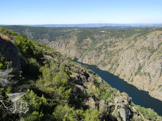
The Ayllón Mountain Range or Sierra de Ayllón is the of the chains that conforms the Spanish Central System Sistema Central, on its easternmost edge.

The Central System was formed during the early Cenozoic Era (the current geological era) in a process called the Alpine orogeny – when the African tectonic plate crashed against the Eurasian plate, a geological event that gave way to the main European and Asian mountain ranges, from Spain in the west to Java in the east.

It rests on a granite base that became first folded, then fractured during the formation of the system. As the rocks eroded, the sediments deposited and formed new sedimentary socks. Other processes that influenced the formation and shape of the ranges have been the action of glaciers and rivers and the subsequent weathering of the exposed rock.

The most common rocks in the Ayllón Range are granite, as expected, gneiss, and slates, some of the latest mixed with clays. For centuries, the villages of the area have been known as “black villages” (pueblos negros) as slate has been extracted to build them. One of such villages is Campillo de Ranas, which translates to something akin to “Little Field of Frogs”, and one of the neighbourhoods adjoined to them is Roblelacasa (literally Oak-the-House).

Roblelacasa happens to be the start of a hiking route to one of the highlights of the range – the Pozas del Aljibe (Aljibe Pools), with Aljibe being a word of Arab origin that means “cistern” or “well”, so not that original a name, I guess. I had been wanting to see these pools – also called a waterfall – for a while, so I decided to drive off and hike the route to see the Aljibe, which is considered one of the most beautiful in the centre of Spain. The hike is about 3.3 km each way – but guess what? I ended up taking a detour or two (≧▽≦). The pools are formed by the Soto Creek, Arroyo del Soto, a tributary to the river Jarama which in turn flows into the river Tagus.

Off I went. The drive took about an hour and twenty minutes. I left home around 8.20 and arrived in Roblelacasa around 9:40. The drive went well, most of the road was a nice national road, and as it was a local holiday traffic was scarce. Some people were in a great hurry though, ignoring speed limits. This was my first time driving on my own with the Sat-Nav, and it went all right. However, as I drove towards the range, there was a dark cloud I did not like one bit.

Just after reaching the “village”, I found a parking spot right behind the panels, as the expected parking lot was closed off. I had packed some frozen water, biscuits, the camera and my cap – but I had forgotten the umbrella, and it was a bit grey. I decided to leave taking pictures of the village for later, and I started walking just behind a couple who had arrived virtually at the same time, but I passed them as they stopped to take pictures.

Information

Roblelacasa

The route is officially named “PR-GU 09: Sendero de los pozos del Aljibe” and it is part of the natural park Parque Natural de la Sierra Norte de Guadalajara. Upon leaving Roblelacasa, the first couple of hundred metres crossed fractured and weathered rock before crossing a symbolic gate that marks official the beginning of the trail with a white and yellow double-line. Then, I walked onto a gravel path flanked by the remains of old fences. To the left opens a valley, and looking back I could see the village, in black.

Start of the route

Old slate fences

Valley

Valley and village

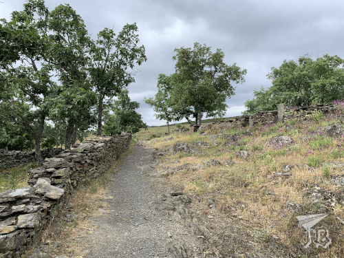
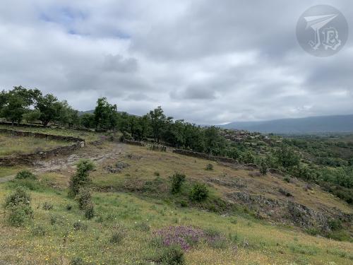
The route widens into a dirt track that is obviously travelled by car sometimes, as the range peaks stand in front of you. There are no trees but a lot of bushes and aromatic herbs, and as you walk the scent is very pleasant. Then there is a small forest and a second barrier, which marks the turn where you are going to start climbing a new hill – slowly, the terrain rises to your left while it lowers on your right, giving way to the creek’s valley. Just before reaching this I passed a family who had started walking before me.

Mountain Range in front

Mountain Range around

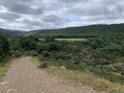
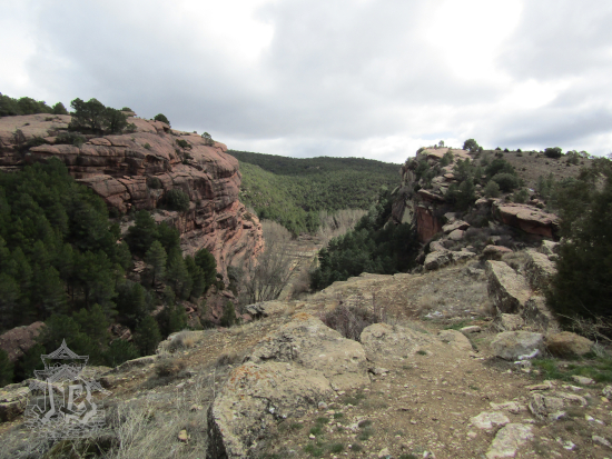
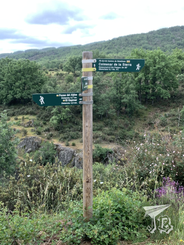
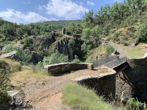
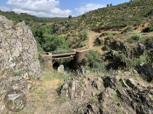
Eventually, you reach a fork in the trail, with the choices of going left towards the waterfall or right down the valley to see a former dam-turned-bridge. I went to the waterfalls, figuring out that I could always go down to the dam on my way back. The track became narrower and rocks started popping up again.

Fork on the way

Valley

Creek in the valley

Geological formations

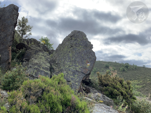
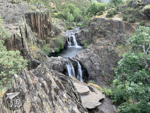
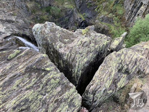
I wandered off the trail (you can see the markings on the upper picture) a couple of times because the views were neat, but a few minutes later I crossed a little bridge to get access to the waterfalls viewpoint on the left-hand-side bank… which was closed. Believe it or not, the actual waterfall area had quite a few “do not walk, falling risk” signs that… okay, I have to be honest… I pretended not to see. I hiked up to the viewpoint and sneaked a little to the side to see both waterfalls. As it has been storming, there was a good amount of water flowing, so the view was pretty cool.

Wooden Bridge

First waterfall

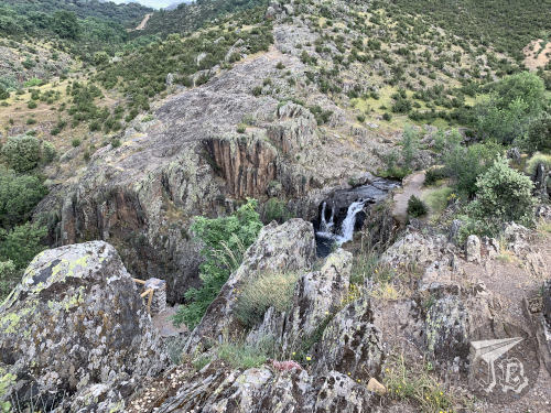
The upper waterfall is about three metres high, and the easier one to see, without needing to ignore any warning sings. When I walked up to the viewpoint I got an amazing view of both the upper and lower waterfalls, the latter being about 7 metres high. It is easy to see how they are called either waterfalls or pools.

Both waterfalls from the left bank

Both waterfalls from the right bank

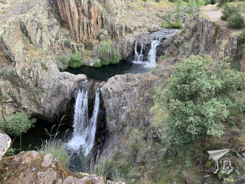
Remember that I said that I passed a family on my way up? This is kind of important because it means that I was basically alone in the waterfall area for about ten minutes, enough to take a good bunch of pictures from both banks of the creek without having to edit people out. I was however very cautious about cracks and faults. I think most of the rocks in the area are quartzes but my geology skills are a bit rusty.

Cracks on the rock

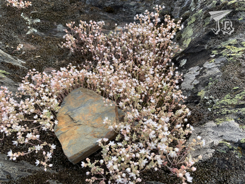
As I decided to turn around, the family arrived, and so did the couple I had first passed and another group that must have started behind me. That was okay because I was done, and on my way back I could stop for a lot of pictures that I had not taken before. Here you can see the difference between the quartz /gneiss (surrounding the flowers) and the slate (in the middle).

Flowers growing from the rock

Also, at some point before I started my return hike, it cleared up. All of a sudden it was hot so first I shed off my sweatshirt and when I reached the crossroads again I really needed a drink and some shade – but I had packed water and the cap, so everything was fine, and I could divert to see the old dam, Presa de Matallana over the creek Soto – from both sides. This must have been around 11 am.

Valley on the way back

Presa de Matallana from the left bank

Presa de Matallana from the right bank

I turned back towards Roblelacasa and I noticed that the wide track was a bit more “upwards” than I had noticed the “downwards”. I had a bit of a tired moment as I adjusted to hiking up in the heat – why is it that normal hills tire me more than uneven paths? But it was over in five minutes and I was back in the village a bit before twelve. On the way now I stopped to take pictures of the flowers and bushes around, and of the valley that Roblelacasa overlooks – and ran into four or five more groups / couples who must have started walking around 11, so it was a good call to get there early.

The track back

Roblelacasa from the outskirts

Flowers on the way

This is how the village looks in the light of day, just before I took the car and drove back around noon. I decided that I would go back to the area some other time to explore other villages around, mainly Tamajón, which is reported to have an interesting geological area, and some other black villages.

The village

Oh, and a the pictureless anecdote of the trip, for obvious reasons. There were a lot, and I mean a lot of “caution wildlife” traffic signals, and on the drive there I thought that I had very rarely encountered any wildlife crossing the road. I had also not come across any wild (or domestic) on the trail, aside from some little lizards and a few pet dogs with their owners. Well, good thing I was driving a good 10 kph under the speed limit, because on the drive back I had to yield to a wild boar! Live and learn (to drive slowly in wildlife areas)!

Driven distance: around 130 km (2h 30min)
Hiked distance: 6.7 km / 11,106 steps (2h 20min)

4th August 2020: Meanders and Curves {Spain, summer 2020}

The area we were visiting that day, called Ribeira Sacra, is sprinkled with Christian monasteries [mosteiros] and churches [Igrexas] in the Romanesque and Gothic styles. These religious sites became commonplace during the Medieval times, along the way that leads up to Santiago de Compostela, an important Christian pilgrimage site. The route is called Camino de Santiago (St. James’ Way).

We started off with a fierce battle against the car’s sat-nav as it refused to take us to our first stop, the church of St. Michael in a tiny hamlet. I managed to trick the navigator and we arrived at the Iglesia de San Miguel de Eiré only a little later than expected. The church is small and it was built in the Romanesque style, which is common the Ribeira Sacra. The church was built in the second half of the 12th century, and has a remarkable archway. Back in the day, it belonged to a monastery.

Afterwards we backtracked to what is probably its successor – another monastery, the Monasterio Cisterciense del Divino Salvador in Ferreira, which was built in three styles – the church is Romanesque (12th century), the main building and the walls are Baroque (18th century) and the inner cloister is Renaissance (16th century). There are also two Romanesque wooden sculptures.

Then we set off towards a salad of curves the heart of the Ribeira Sacra, the area of the River Sil where the water has excavated a deep canyon – well, ish. There was a lot of tectonic activity going on in the area a long time ago that helped the development of the river canyon, the Canón do Sil. It is dammed at the moment, which has made the river depth increase.

We had booked a “cruise” in a “catamaran” that turned out to be a plain-old boat and way too packed for my peace of mind. Fortunately everybody wore masks, we had the N-95 that protect both ways ones, and used a lot of hand sanitiser – my nails are really, really off due to the use and abuse of hand sanitiser. We sailed off the wharf Embarcadoiro do Santo Estevo and the views were pretty nice. Both the narrator and narration not so much, though the bit about the “special” vineyards perched on the canyon walls was interesting.

After a ninety-minute sail, we disembarked and took the car again to drive to the Parador de Santo Estevo to have lunch (cue stamp number three), where I tried the local beef with foie, while the rest went for the octopus.

Then we took a stroll down the Parador, which is an old monastery that has not one but three cloisters, as the Monasterio de Santo Estevo de Ribas de Sil has existed since the tenth century and buildings have been added. Two of the cloisters are Renaissance and the third is Baroque / Gothic.

Finally we stopped over at the church, whose interior is late Romanesque but with a later façade (and a very Baroque altar).

And then we went back to the curves. Lots and lots of curves. The road ran along the canyon, so we stopped over at a couple of viewpoints to observe the canyons – Miradoiro de Cabezoás:

Miradoiro Balcones de Madrid:

Then we continued onto the ruins of another Romanesque Monastery, Mosteiro de Santa Cristina de Ribas de Sil, with some very nice paintings and a very pretty cloister.

Afterwards we drove back up the road and we found another viewpoint Miradoriro Xariñas de Castro (a.k.a. Miradorio A Mirada Maxica) for more views of the canyon.

We continued to the monastery Mosteiro de Santa María de Montederramo, where we had booked at 19:00 but could join the 18:00 visit instead. Shifty, I know, but we were there at 18:04 and… yeah. Not really worth the wait, even though the Gothic church and cloister were neat, even if a bit unkempt.

And as we were finally driving back towards Monforte de Lemos, we came across the castle Castelo de Castro Caldelas, which was actually on the planning for the next day but we thought we would… how to put this… avoid some curve-driving if we took the stop.

All in all: 135 km driving; 6.96 km walking; around 20 km sailing; hundreds of curves.

3rd August 2020: On the road again {Spain, summer 2020}

After having to cancel London and Greece, we decided to try to at least take a few-day’s worth road trip within Spain as some sort of consolation prize. We were, of course, very careful, using a lot of hand-sanitizer and never taking off our face masks except within the car, hotel rooms or when we were eating – strictly so.

We started off just in time so we surrounded Madrid right after rush hour so we did not get caught in any traffic jams. We drove northwards towards Medina del Campo, a town which played an important role in Spanish history, specially around the time of the Catholic Monarchs and their direct descendants. We were there at 11:00 sharp, right at the time when the castle Castillo de La Mota opened to visitors. Mota is the Spanish word for motte, which is a raised area of ground where a castle keep, and a walled courtyard or bailey, are built. They are protected by a ditch and a palisade. These castles are thus called motte-and-bailey castle. In particular, the castle of La Mota is made of red brick, typical to the area, but it is heavily restored today. The visit included the outer building, the yard and the chapel of St. Louise.

We stopped for a quick lunch at the Parador de Puebla de Sanabria. Paradores is a Spanish brand of state-owned hotels and restaurants which have a good reputation all around the country. In our lunch stop, I got my stamp passport because I can find stamp rallies wherever they are (≧▽≦), and Paradores has launched one.

Then, as we were a couple of hours ahead our very informal schedule, we decided to take a small detour and check out the Parque Natural del Lago de Sanabria y alrededores, the natural park that surrounds the biggest natural lake in Spain, Lago de Sanabria. It is also one of the few, if not the only glacier-origin lake in Spain. It was full of people swimming and sunbathing, but the landscape was still beautiful.

After lounging for a while we continued on our way towards Galicia and our destination, Monforte de Lemos. We stayed at the Parador de Monforte de Lemos, situated in the Monastery Monasterio de San Vicente do Pino at the top of a hill. It is part of a monumental compound, along with the former castle Keep and the palace of the former Count’s family, Palacio de los Condes de Lemos . Due to some kind of fluke, my room was doubled as “supreme” and the door came out to the actual cloister of the monastery, which was super-cool! (Also: Stamp number two)

We took a short stroll down the village, and we passed by the small sanctuary to the Virgin Mary’s image Santuario de la Virgen de Monserrat.

Then we saw the walls and the old gates.

Finally, we went back to the hotel to have dinner over there. Our choices included trying a species of scallop I had not tried before, the zamburiña, variegated scallop (Chlamys varia). We also tried the local pie, empanada. For dessert, they had a ‘variety of chocolates’.

The day finished watching the sunset before turning in for the night.

Driving distance: Aprox. 600 km
Walking distance: 5.02 km

25th March 2018: Main roads that feel like secondary {Dinosaurs in Teruel, 2018}

We arrived in the Albarracín area after driving for about three hours. Some of the roads were horrid and I was secretly glad my offer to drive had been rejected. We arrived in Albarracín around 11:00 and our first stop was the first Dinópolis mini museum, called the Mar Nummus (Nummus Sea).

As this mountain range used to be sea bead (like 150 million years ago), a bunch of marine fossils can be found in the area. Dozens of ammonites fill up the museum, along with the skull of a Liopleurodon, a marine reptile of the order of the family Pliosauridae, quite obviously a carnivorous one judging by the teeth. As a matter of fact, it was the apex predator of the Middle and Late Jurassic oceans.

Mar Nummus building, featuring a life-size liopleurodon + the skull of the liopleurodon + a lot of ammonite fossils

The visit did not take long, and then we moved on to drive to the Mirador de la Escombrera (Slagheap Viewpoint, don’t ask me) to watch the pineforest Pinares de Rodeno. We decided against walking through the forest because the shortest route was a couple of hours already.

Sandstone cliffs + pine trees

Instead, we drove back to Albarracín and walked throughout the historical centre, a medieval nucleus of streets and houses dedicated to shops and restaurants catering to tourists.

Albarracín, a Medieval city in reddish tones. It is surrounded by a wall

We had lunch, then drove the short 40 minutes to Teruel, where we found our hotel. After dropping our things off, we walked to the centre of the town – which was barely a ten-minute stroll away. Carlos Castel Square is widely known as the “little bull square”, Plaza del Torico.

Teruel is known, aside from dinosaurs, from its Mudéjar style buildings, such as the Towers or the Cathedral. Mudéjar style was used by Iberian Christians between the 13th and 15th Century. It incorporates motifs, decorative elements and construction techniques that were common in Muslim Al-Andalus (such as archways, porcelains, bricks, and so on…). On the first day we saw two of the Towers: Torre de San Pedro (left) and Torre de San Martín (right).

Mudéjar Towers

The second architectural characteristic of Teruel are the Modernist houses, built in the 1910s, such as the ones in the Plaza del Torico – Casa La Madrileña (left) and Casa del Torico (right).

Plaza del Torico: a little bull standing on top of a column. Behind it stand two Modernist Houses at dusk

After this we had dinner and we headed back to the hotel.

28th August 2015: Matsushima and Sendai {Japan, summer 2015}

The day started in Matsushima [松島], the Pine Islands, where there are… lots of pines. And temples. We paid the small fee to cross the bridge to the biggest island, Oshima [雄島] and headed off there, to just walk around it. There were pines and other trees, but I am no tree expert, so… I could identify the pines… However, there were nice views and it was a good way to start the morning, even if I was not feeling 100%, as I had a small accident coming out of the station that ended up with me sprawled on the floor. Not fun.

This bridge survived March 11, although a smaller similar one was destroyed. In general, the area was quite spared by the tsunami.

A walkable bridge with concrete ground and vermillion guards that crosses the bay towards a rocky island with small pines

View from Oshima into the bay:

A view of the bay. There are pine branches in the foreground, and two small rocky islands with more pines

After the main island, we visited a few of the temples around. First, Zuigan-ji [瑞巌寺], which has some really cool cave altars.

A standing Buddha in front of a cave sanctuary.

Entsuin [円通院] – Mausoleum of Date Mitsumune.

Main building of a temple. It's made of wood so old that it has turned white-grey

Back in Sendai, our first stop was the combini Ōsaki Hachimangū [大崎八幡宮], also known as the Black Shrine, as it was supposedly erected to enshrine the kami of war. It was ordered by Date Masamune, who was a very important figure in the history of feudal Sendai.

Shrine, built in black with golden decoration

Though we did not make it to Date’s mausoleum, we did see the sculpture erected in his honour up on the ruins of Aoba-jō [青葉城]. Here are the Date Masamune memorial on the ruins of Aoba Castle

Statue of a samurai, riding a horse. The samurai has a crescent decoration on his helmet. The horse is mid-step, with its front right leg bent

View of Sendai from Aoba Castle:

A view of the skyline of Sendai with a line of trees in front of it

Afterwards, we headed back to the station as we had to catch the 19.30 train, since we had an appointment in Ginza [銀座] at 22.00. We had a reservation for VAMPS Joysound special karaoke booth, which was normal karaoke, but in a room decorated with VAMPS stuff and a special video, along with some themed drinks. Just one of those cute fandom money-drainers activities.

The Vamps karaoke booth and theme drink