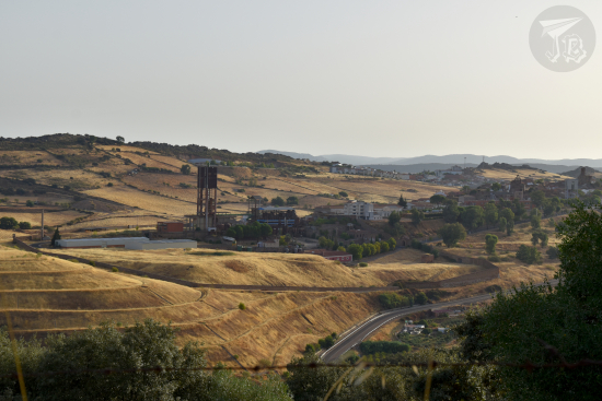
Though October is usually my holiday month and I can go on long trips (such as Türkiye in 2024), this year I came across an unexpected project. That means extra money, but less time, and even though I had a blast in Loarre and Zaragoza, it was not really a holiday. I decided to take a day trip before the weather turned and work took over. I mulled over several ideas, and in the end I came down with two – basically an urban day trip or rural day trip, and in the end, I decided to go for the urban trip. A while back (longer than I thought), I visited Complutum, the archaeological remains of the Roman town which stood underneath what today is Alcalá de Henares. That time, one of the main buildings was closed off due to archaeological works, but it was now open. Furthermore, the city has recently opened a new museum. These factors pushed me to go there in the end. It helped that I needed to do some shopping.
The Romans first established provinces in Hispania around the 200 BCE, after the second Punic War. In the year 19 BCE, the first Roman Emperor, Augustus, formally added the Iberian Peninsula to the Empire. Despite some strife, Spain remained part of the Roman Empire until the latter collapsed in the 5th century CE. There’s a lot that Spaniards owe to the Romans, including a good road system, aqueducts and waterways, and lots of mosaics, a good number of them in the MARPA.
The city of Complutum was founded in the 1st century CE, and greatly expanded through the 3rd century. At the turn of the 2nd century, during the Christian persecution, two children were killed and are now considered martyrs. Unlike other sites, the city was never really abandoned, just gave way to newer civilisations and it was built over. During the 19th century, the archaeological sites were pillaged, and between 1970 and 1974 a lot of the remains were destroyed to build new dwellings. The archaeological site received protection from the 1985 Heritage Law, and further recognition as Cultural Asset (BIC) in 1992.
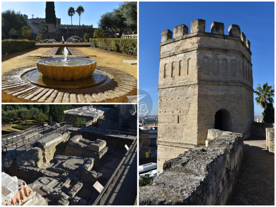
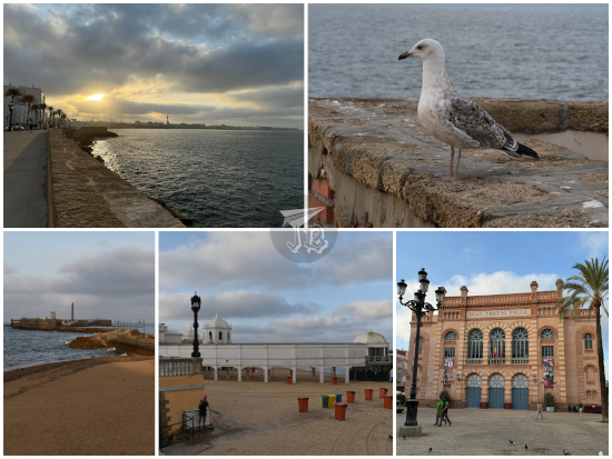
I did not feel like driving in the chaotic Alcalá de Henares traffic, especially now that they’re having construction along the main avenues, so I parked the car a bit away and walked – this is something I do when I go to the centre. The weather was nice so the 40 minutes did not feel long. I visited the three main spots: the larger archaeological site Ciudad Romana de Complutum, the new museum Antiquarium and, since I was not crazily far, the house Casa de Hippolytus.
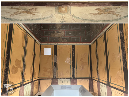
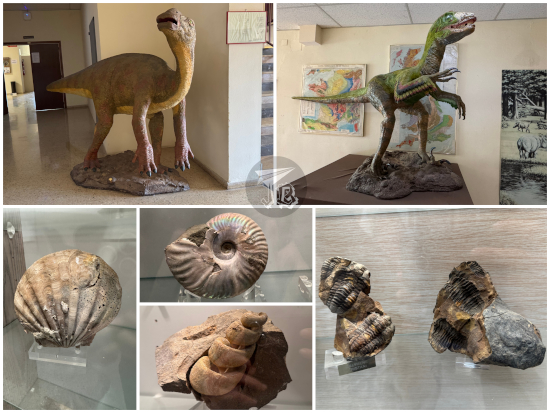
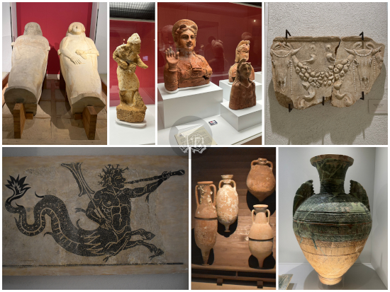
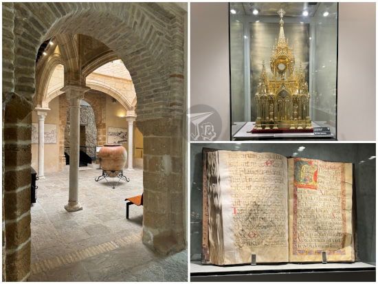
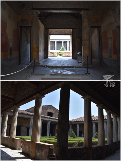
I first headed off towards the Antiquarium, the “new” museum. I call it new because it has opened in 2025, though the building had been erected over a decade earlier at the very least. It is a large space which hosts some of the elements recovered in recent excavations – though due to the general pillage of the site in earlier centuries and all the losses due to modern construction, it is not as rich as it should be in its own right. There are two key elements in the museum – room F of the House of Griffins, and the mosaic of the Winning Chariot Racer.
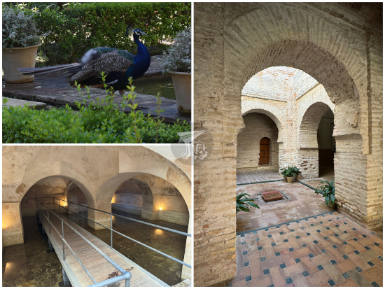
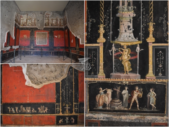
The House of Griffins, Casa de Los Grifos, is considered the best example of Roman mural painting in Spain. It was a large domus of 17 rooms at least. It was built in the 1st century CE, but it burnt and collapsed in a fire at the beginning of the 3rd century. Outside of Pompeii, it’s probably one of the best preserved houses I’ve ever seen, even if it is in two places. The room moved to the Antiquarium names the house. Amongst other mythological representation, the entrance is guarded by two griffins, animals with the head of an eagle and the body of a lion, facing each other.
The other key exhibit is the mosaic El Auriga Victorioso, which was found in an outskirts villa where Romans bred horses. The museum has woven a whole story around the mosaic, to the point that you could actually believe that everything they tell you about the hypothetical character is based on facts instead of just speculation.
Outside the building there is a fountain Fuente del Juncal, part of the water distribution system of the city, channelling water from the nearby river Río Henares. It was heavily restored in the 19th century, so there is no way to know how it looked originally.
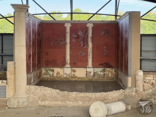
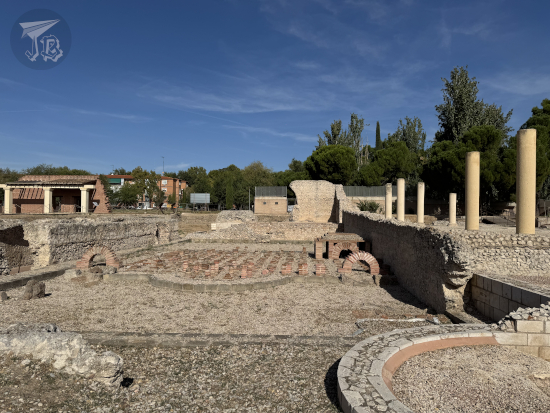
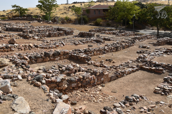
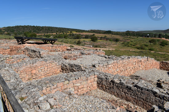
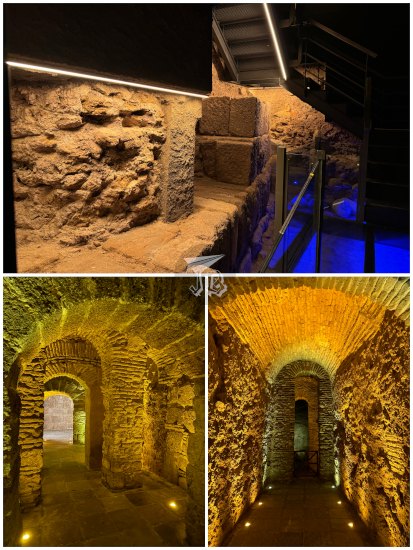
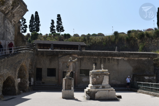
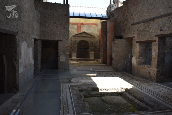
After the museum, I headed to the actual city to see the rest of the House of Griffins in situ, in the Ciudad Romana de Complutum Roman city. The vermilion walls which still stand were probably painted with cinnabar from Almadén. However, it was difficult to see from afar what parts were original and what had been restored. Other spaces that can be seen throughout the city are the foundations of a dwelling block, the forum and the therms. Two spaces require a lot of imagination – a piece of wall is supposed to be where the child martyrs Justus and Pastor were killed, and the restored auguraculum, where the oracles worked.
The last time I visited Complutum, the Antiquarium had not opened and the House of Griffins was closed due to excavation works there. I did visit the other house Casa de Hippolytus, which was completely accessible. However, since I was nearby, I decided to get there again. They have a very cool mosaic with Mediterranean fishery themes, including a moray eel, an octopus, a dolphin and a very-accurate lobster. Interestingly enough, Hippolytus was not the owner of the house, but the artist who signed this mosaic.
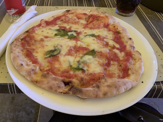
I headed back towards the shopping centre where I had left the car and went into a The Good Burger there, because I am very partial to their Cheese Lovers hamburger (and their soda refill policy). They had a menu option so I decided to go with the chips – I had the choice between chips with salt and chips with salt (and that’s not my typo). The burger in question is garnished with American cheese, goat cheese, Gorgonzola cheese, poached onion and honey-and-mustard sauce. Lots and lots of cheese, for real.
I did not do much afterwards. I bought a few items I needed and headed to the car to drive home.
The lady in Almadén had recommended a pretty hermit-church-castle place in the nearby village of Chillón, but when I reached there, it turned out to be closed and expecting a bike race, so if I stayed… well, I would have to stay till the race was over. I left as fast as I could, so I was not able to see the church Ermita Virgen del Castillo and the Bronze-Age paintings nearby. I just stopped for a quick picture of the mining park Parque Minero de Almadén.
I stopped for fuel, then went onto the road. It took a couple of hours until I reached the village of Alarcos. Nearby stands the archaeological site Parque Arqueológico de Alarcos, which displays three historical periods – there are remains of an Iberian town, a ruined castle, and a Reconquista battlefield. The Iberian town was built around the 6th century BCE, located all over the hill. There are remains of a neighbourhood, a sanctuary, and further away, a necropolis.
During the Middle Ages, there was a project to build a town and a castle. The town would have been protected by a wall, and the castle would have stood at the highest point. However, Alfonso VIII decided to fight a battle against the Almohad Caliphate there before the castle was finished. The battle of Alarcos happened in 1195, and the Christians lost miserably. The castle was then turned into an Almohad town until the battle of Las Navas de Tolosa recovered the whole area in 1212. However, nobody wanted to live in the town any more, so eventually its population would be moved to “The Royal Villa”, later the Royal Town – Ciudad Real, the current capital of the region.
There is also a small hermit church, but that was locked away behind a fence. The castle is extremely derelict, though some of the Moorish houses can be guessed on the blueprint. Any archaeological findings have been taken to the museum in Ciudad Real – which I still have to visit, but timing was not on my side today. Fortunately, that is doable on public transport – if I ever decide to trust Spanish long-distance trains again.
On my way out, the nice person at reception gave me a bag of goodies – a booklet about the site, some brochures, a magnet and a Medieval music CD. She recommended my trying to reach a hermit church on the other side of the motorway to find the interpretation centre about the prehistoric volcanos in the area, but that is for another, focused trip.
I just hit the road to get home. There was an accident on the way and the subsequent traffic jam added an hour to the drive. The last 40 minutes or so, I felt very tired, so even if I had wanted to have lunch somewhere, I also had the feeling that if I stopped, it would be harder to keep driving. I made it home around 15:30 and had a very late lunch.
I consider the trip was a success. I saw the Mine, which is something I have been wanting for years. Food in Almadén was horrible, and maybe future road trips should be broken with a night in-between, so lessons were learnt. More supermarkets, more overnight stops. But I only had a long weekend, so I made the most of it. And splurged on a mercury vial for my mineral collection.
I woke up early – way before the alarm clock went off, so I decided to hit the road. I first topped up the fuel tank at the cheap petrol station near my place. Afterwards, I drove off to the motorway and the morning rush hour. As I was caught in the traffic jam, there was a pretty rainbow in front of me – no pictures, though, for obvious reasons. Traffic dwindled a lot when I left the A2 behind and merged onto M50. From there, I took a couple of hours to reach my first stop, the village of Consuegra. On the mountaintop of the so-called Cerro Calderico, in the outskirts of this ten-thousand inhabitant, stand some the best examples of restored traditional windmills.
During the Middle Ages, the area in central Spain known as La Mancha proved a challenging place for watermills, the dominant technology at the time. The rain regimes cause irregular river flow, with a lot of the currents drying up in summer. As demand for flour grew, windmills were built near but outside towns, on high ground. They provided clean flour, cheap enough to be affordable, without being subjected to draught or flood seasons changing. The windmills lived its golden age from the second half of the 16th century until almost the 20th. Towards the end of the 1800s, most of the cereal crops were exchanged for vines in order to supply wine to France, leading to the decay and progressive abandonment of wind-milling. The Industrial Revolution and the appearance of fossil fuels and electricity finished off whatever little remained in the early 20th century.
However, besides their practical function, there was something else about the La Mancha windmills. They had gone viral centuries before the Internet was a thing. In the year 1605, Miguel de Cervantes – considered the greatest writer in the Spanish language – wrote his masterpiece El Ingenioso Hidalgo Don Quijote de la Mancha, worldwide known as “Don Quixote”. The novel is amongst the most translated literary works in the world, and tells the tragic story of a minor nobleman, the title character, who goes crazy from reading too many chivalric romances. He decides to leave his home and become an errant knight, having great adventures in his mind, which are more misadventures in real life. He is accompanied by a farmer-turned-squire, Sancho Panza.
During one of his delusions, Don Quixote fights giants with long arms – which the reader knows, from Sancho’s warnings, that are in reality windmills. Of course, the madman is “defeated” by the blades, which shatter his spear on impact. It is one of the most famous passages of the book, even if it is barely a page or two in the eighth chapter. Throughout the novel, which starts “in a village of La Mancha, the name of which I have no desire to call to mind”, several locations are explicitly mentioned, others are implied, and some have completely imaginary names. Experts have placed this fictional encounter with windmills either in Consuegra or Campo de Criptana – which was not on my route.
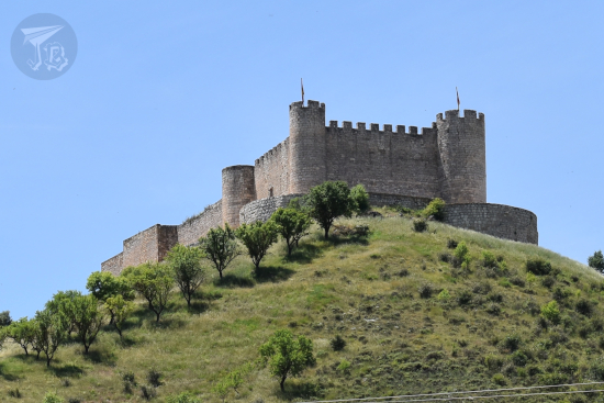
Thirteen windmills were built in the 19th century on the Cerro Calderico, and twelve have been restored and turned into tourist attractions – one even works. They stand in a row alongside the ridge and next to the local castle Castillo de la Muela (or Castillo de Consuegra). After all, both castles and windmills need the higher ground to be effective, in a way. The castle already existed in the 13th century, with roots in a 10th century previous fortress.
I parked at the foot of the hill and walked up to see the castle and the windmills. The castle was closed as it was a local holiday, and the fortress is managed by the town hall. I stayed around for an hour or so, walking from one end of the hill to the other. I had a snack as I snooped around, then I moved on.
My next stop was the National Park Parque Nacional de las Tablas de Daimiel, a weird place. I call it weird because despite its status as a protected area, it has been on the brink of collapse for the last century or so. The wetlands have been drying out for decades.
The area is the literal last of its kind in Spain, a kind of wetland generated when rivers break their banks in their middle course on flat terrain. In the middle of the de facto Spanish Inner Plateau desert, it is formed by the rivers Guadiana (fresh water) and its tributary, the Cigüela (brackish water), and fed by a number of underwater aquifers. These have been exploited for farming, which seems to be the cause for the dessication. So out of what it should be, there is only one medium-sized pond, Laguna de Navaseca (usually referred to the “permanent pond” Laguna Permanente), where a number of birds, fish and amphibians live either seasonally or all year round. The area was designated a national park in 1973. Later, it received other protections, especially regarding the bird population.
I parked in the allocated space and had a sandwich before I went in. The visitors’ centre was manned by a very disgruntled employee who explained the dessication to me as if I were personally responsible for it. I really felt like apologising. The truth is that the first place I visited was the pier, which has not seen water for at least a decade. I could do two of the three walking routes, but in the end I only did one and a half, as the second I tried was way hot and dry and I gave it up three-quarters in, as there was no water any more.
In the end, I stayed around the main pond Laguna de Navaseca, where wooden walkways have been built. I felt horribly guilty whenever the wood cracked under my feet and I scared the ducks away, but the local guides could be heard from across the whole pond. On the banks, there are bushes of common reed (Phragmites) and rushes (Juncus). The only tree in the area is the tamarix (Tamarix gallica), small and brime-resistant.
In the pond – and flying over it – I found a flock of greater flamingoes (Phoenicopterus roseus) – which are for some reason not listed anywhere that explains the park. I also saw herons, ducks, geese and I swear ibises – the latter are not mentioned either, but my bird identification book suggest a glossy ibis (Plegadis falcinellus). I was hoping that autumn had modulated the temperatures a bit, but it was extremely hot. It was also… stupidly dry for wetlands… That is why I gave up on the second route halfway.
I went back to the car and drove to a small parking lot at the entrance of the park which allows you to see the watermill. It was closed, and again dry, but it was an interesting structure.
I continued on the road towards the archaeological site Yacimiento Visitable de Calatrava la Vieja in Carrión de Calatrava, which has a very nice and shaded parking area, where I had my second sandwich as I was there 30 minutes before schedule – read: they had not opened yet.
The archaeological site is considered one of the most important of Moorish origin in Spain – a city and a castle from that period, erected on older remains, probably Iberian. Back during the Arab vs Christian wars in Spain, the fortress was right in the middle on the way between Toledo and Córdoba, along with other important commercial routes, so it became a key defence point. It is known that the castle already existed before the 8th century, on the Guadiana riverbank. When it fell to the Christians around 1150, it became the first line of defence, and it was entrusted first to the Knights Templar and then to the Cistercians. It became the birthplace of the first Spanish military order, the Order of Calatrava Órden de Calatrava.
The castle was built on a plateau, defended by the river itself and the walling structure, which included at least 44 flanking towers. There were four fortified corridors (corachas) that protected access to the water. The entrances to the inner fortress had several turns to make them easier to protect. Between the inner core and the walls stood the medina, the Islamic city, and the alcázar rose as a sort of triangular keep, accessed through a triumphal arch. The inner castle itself is the best-preserved area, having even rebuilt furnaces to make clay. During the Templar times, part of the alcázar was repurposed into a budding church which was never finished. On one of the inside walls there are carved drawings of vessels.
As I climbed the walls, clouds had started gathering and the wind had picked up. I decided to get going, trying to outdrive the storm. At first I thought I had been lucky, but about 20 minutes away from Almadén, the skies opened and there was a torrential downpour. I was lucky enough to find a parking spot where I hoped, down the corner from the hotel, and I have an umbrella in the car. A few minutes after parking, the storm stopped though, albeit the rain did nothing to cool down the evening. I checked in, and the hotel lady gave me a map with all the spots that have been inscribed as World Heritage Heritage of Mercury. Almadén and Idrija.
Mercury (chemical symbol Hg) is a native metallic element, the only one which is liquid under normal temperature and pressure conditions. In nature, it is usually found as cinnabar (mercury sulphide, HgS), a bright scarlet mineral. Its formation is linked to volcanic activity and alkaline hot springs (the area of Ciudad Real comprises the extinct volcanic field called Campo de Calatrava, which I drove through, but found no way to stop anywhere to explore). Liquid mercury, also called quicksilver, is extracted from cinnabar by heating it, as sulphur evaporates with heat.
Mercury is toxic to the nervous system, dissolves gold and silver, and has long been associated with “mystical” powers and sites – the first emperor of China was buried in a tomb with rivers of mercury, there is mercury under one of the Teotihuacan pyramids in Mexico, and in the end it carries the name of the Roman God of Messengers and Travellers. It has fascinated humans throughout history.
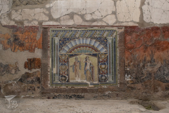
The name of the five-thousand-inhabitant town, Almadén, comes from the Arabic Al-maʻdin [المعدن], which means “The Mine”. The site was already exploited in times of the Romans – the extracted bright-red cinnabar was used to create vermilion paint for the walls of Pompeii and Complutum. When I was a child, my history book had some information on Almadén, and the accompanying photograph showed someone who had thrown a cannonball into a mercury pool, but the cannonball was floating on it. I have wanted to see the mine since then, even knowing that there was no way I would ever see that one pool any more, due to the legislations that have deemed mercury as “too toxic for anything”.
I went to have a look around town. It was dusk and everything was closed – not that many things would open the next day anyway. I did a small circular walking tour which included the main church Iglesia de Santa María de la Estrella, and down the main street the central square with the town hall Ayuntamiento de Almadén and the church Iglesia de San Juan. I continued on and found the the old mining school Antigua Escuela de Ingeniería de Minas. To the side of the street stands the former castle point Castillo de Retamar, where only a turret remains. Up a little, I reached the third church, Iglesia de San Sebastian and the ruins of the manor house Casa de la Superintendencia.
I undid my path and headed to the other side of town. In a secondary square there is a monument to miners Monumento al Minero, and across the street the bullfighting ring Plaza de Toros de Almadén. My final stop was the former hospital Real Hospital de Mineros de San Rafael. I had dinner at the hotel restaurant, which honestly was a little disappointing.
I headed back to the room to have a shower and some rest, and get ready for the following day – and try to digest dinner.
I woke up and for the first time in days I put on “person clothes” (for the city) instead of “scarecrow clothes” (for hiking & working in the field). Before setting off on the trip, I went to the sales to buy some jeans that would work for sitting on rock or walking through thistles and dry grass, and while they are not particularly nice, they are comfortable and resistant. Saragossa / Zaragoza was still waking up as I headed for breakfast to a bakery close to the hotel, Pannitelli Original Bakery, which I had chosen for two reasons. One, they opened at 7:30, which gave me plenty of time to walk to the university afterwards and two, they had waffles, I had seen them online. I wanted waffles, and a big coffee. I had both (and some orange juice, just because I could).
It turned out that not driving to the university Universidad de Zaragoza had been a great idea. Though it had been my first thought (dump the car there, then walk to my accommodation), I was lucky that in the end I was able to reserve my parking spot with the hotel. It happens that access to campus is restricted to working staff. Students can drive into the parking lot ten times in the school year. And on top of that, there was a farmers’ market for some reason.
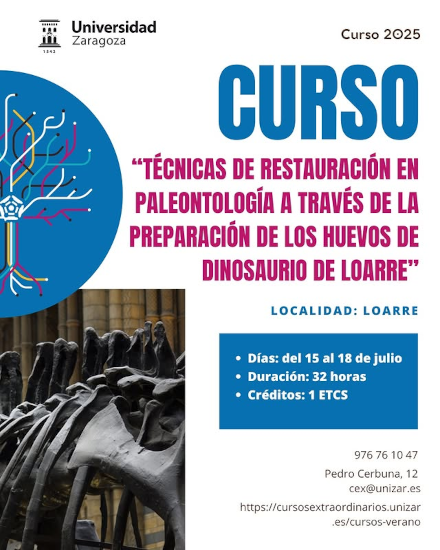
Having 20 minutes to walk, I was the first one there, and I sat down in the rock garden of the Earth Sciences building to wait for everyone else for the last day of the course Técnicas de restauración en paleontología a través de la preparación de los huevos de dinosaurio de Loarre: Palaeontological Restoration Techniques through the preparation of Loarre dinosaur eggs. By 9:00, when class was to start, I was the only one besides the teachers who had managed to arrive. Everyone else had either got lost, left Loarre late, or was taking forever trying to park. So yay me being lucky for once (and for the 20 € which the hotel parking cost for the whole stay).
The first chunk of the morning was a tour through the Rock and Hard Material Preparations, 3D Printing and Scanning Service (Servicio de preparación de rocas y materiales duros, impresión y escaneado en 3D) in the university. They have two main lines of work. One is to make thin translucent sections out of specimens so they can be studied under the microscope, and the other is digitalising and making 3D models and copies of items so they can be lent or studied through a computer. The inner works of the department were explained by Raquel Moya Costa, who not only described in detail all her complex machinery, she also gave each of us a 3D printed T-Rex charm from the Dino Run Game!
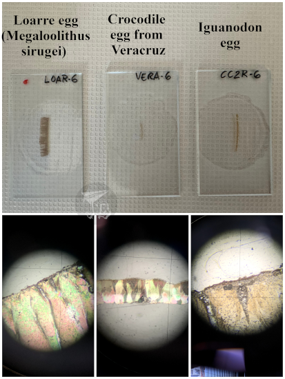
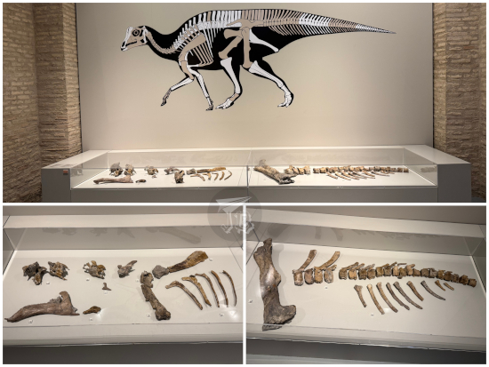
We then moved onto the Petrology lab to look at thin sections on the transmitted-light microscopes – preparations of a sauropod eggshell, a crocodilian eggshell and an iguanodon eggshell. There were other preparations we could snoop around if we promised not to take pictures and publish them. We also got to play with the 3D copy of one of the first eggs recovered from Loarre. Much less heavy than the real thing, for sure.
Then a bit of chaos ensued as we got distracted by the shiny exhibits of the Palaeontology department, and a couple of post-docs offered to show us their lab and what they were working on. Having finished all the activities of the course, the coordinators had organised an extra visit to the Natural Science Museum Museo de Ciencias Naturales de la Universidad de Zaragoza (which might have actually been my fault as I asked how come that would not happen, considering that most of the region’s fossils are officially deposited there). A few people left first, but some of us got delayed looking at the lab specimens, and then we had to hurry to the museum…
Once we were at the site of the Museo de Ciencias Naturales, we were taken on an express visit of the palaeontology ward by Ester Díaz Berenguer, curator of the collections. The museum is located in one of the historical buildings of the Zaragoza campus. Designed by Ricardo Magdalena in 1886, it was erected with academicist criteria, in brick, with large windows and striking symmetry. It opened in 1893, and during the 20th century, it served as Faculty of Medicine. When the university moved to the newer campus, the building was refurbished as cultural spot and seat of the government body. The basement was turned into the exhibition site of the Science Museum, which has three main areas – palaeontology, natural science, and mineralogy.
The palaeontology ward of the museum comprises nine rooms. The first one is an introduction to the science and the concept of fossilisation, and the following ones run through the Earth’s history, from the Precambrian to the Quaternary. The Precambrian is the earliest “calculated” period in geological time, and spanned from 4567 to 539 million years ago (give or take). Though we cannot pinpoint when life actually originated, it was already there when this “supereon” gave way to the Cambrian. During the Ediacara Period, at the end of the last Eon of the Precambrian, the Proterozoic, the earliest complex multicellular organisms that we know about thrived in a state that has been called “The Garden of Ediacara”. The word “garden” tries to evoke the idea of the “Garden of Eden” as there was no active predation and life just… existed.
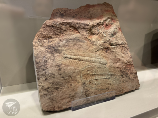
The next rooms focus on the “Cambrian Explosion”, a term used to refer to the point in geological time when living things took over the planet. At first, this brand-new life was comprised of ocean-dwelling invertebrates. In the room there are impressive trilobites from the Murero Palaeontological Site, which I had actually planned to drive through on my way back. But not only animals appeared, so did plants – organisms which produced a new toxic gas that would change the planet forever: oxygen. To the side of this area there is a curtained room, the “aquarium”.
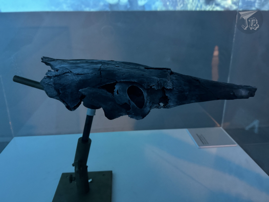
Here you can see the cranium of Carolowilhelmina geognostica, a fish which lived around 392 million years ago, during the Devonian period. It was a placoderm, a group whose main characteristics were being covered in armoured plates, and having developed an actual jaw and true teeth. The specimen is not just the holotype, it is the only known fossil of the animal. The cranium alone measures almost 45 cm, and by its shape, palaeontologist speculate that the animal was probably a predator of invertebrates. A first fragment of the fossil was found in Southern Aragón in 1971 by palaeontologist Peter Carls. Carls kept returning to the site to search for the rest of it every summer, until in 1986 he unearthed the rest of the skull, which was finally extracted in 1993.
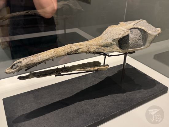
The following room is devoted to the Mesozoic, and it hosts another of the museum treasures, the skull of the holotype and only specimen of Maledictosuchus riclaensis, the “Cursed Crocodile from Ricla”. This crocodilian lived in saltwater around 163 million years ago, during the Middle Jurassic. It had flippers instead of legs, and probably ate fish. The fossil was found during the construction of the high-speed railway between Madrid and Barcelona in 1994. It earned the name of “cursed crocodile” because despite the fact that it was the oldest crocodilian found in Spain, exceptionally preserved on top of that, it took 20 years until someone could tackle its study and description. The “curse-breaking” researcher was Jara Parrilla Bel, one of the post-docs who shown us her lab work at the university.
Of course, the “stars” of any palaeontological exhibit are dinosaurs. The museum hosts several iconic pieces, amongst them replica of the feet of the first dinosaur ever described by researchers belonging to the local university Universidad de Zaragoza, Tastavinsaurus sanzi (a titanosaur), a whole specimen of the Mongolian Psittacosaurus (a small ceratopsian), and a good part of an Arenysaurus ardevoli, a hadrosaur which lived in the Pyrenees area around 66 million years ago, during the early Maastrichtian; the rest of the specimen is located in Arén, where it was located, and which is one of the museum’s satellite centres, just like Loarre’s museum-lab. In the same room there were trunks of fossilised wood that could be touched, and a skull of the extinct crocodile Allodaposuchus subjuniperus.
After a small room with an audiovisual representing the impact of the meteorite and the K-Pg mass extinction (which we skipped due to time constraints), there was an exhibit of the spread of mammals. The specimen of honour in this exhibit is the ancient sirenian Sobrarbesiren cardieli (holotype, and the topic of our guide’s thesis). This species lived during the Eocene, around 45 million years ago. Sirenians (manatees and dugongs) are a type of marine mammals whose closest relatives are elephants – and not other ocean-dwelling mammals. After life spread through land, a number of mammals went back to water, and it looks like this species is a snapshot on the readaptation process: it was already completely aquatic, but it still had four functional limbs. Its hind legs had started reducing and its tail was getting flat. It was a strict herbivore, eating sea grass, but less efficiently than current sirenians.
There was also an impressive aquatic turtle of the genus Chelonia, several remains of Gomphotherium angustidens, an elephantimorph, and smaller pieces including crabs, sea urchins, gastropods and even insects. Several of these specimens are holotypes, too.
The final area was almost contemporary considering when we had started. It hosted remains of cave bears (Ursus spelaeus, 40,000 years ago), the skull of an aurochs (Bos primigenius, a species that actually lived until the 1600s), evidence ancient hyena nests, micro-invertebrate bones, mammoth defences… These animals coexisted with human beings, whose skulls comprise the ending room before moving onto the “nature collections” which we did not visit because a) the course had after all to do with palaeontology and b) it was closing time – quite literally, museum security was turning off lights behind us since the museum shut down at 14:00.
We had a mini closure “ceremony” in the hall of the building – coordinators Miguel Moreno Azanza and Lope Ezquerro Ruiz thanked us for attending, we clapped and thanked them back. Then we all went off to have a drink, a snack and a chat. A bit after 16:00, when most students had already left and the professors had been joined by university staff, I took my leave.
Hopping from shadow to shadow to avoid the sun and the heat as much as I could, I headed downtown. On my way I made an exception regarding the walking in the shade when I found the only remaining gate of the original Medieval Wall, today called Puerta del Carmen. Calling it “original” is a bit of a stretch though. While it is in the same place as the first gate, it actually dates from the early 1790s, and it follows Neoclassical patterns.
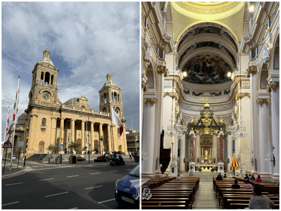
I also stopped at Starbucks for a Vanilla Frappuccino – I’m on a bit of a matcha remorse trip due to the alleged shortage, so I’ve reverted to my old drink of choice. With a temperature of around 38 ºC, I reached the most important square in town, Plaza de Nuestra Señora del Pilar, where the namesake basilica is. I kid you not, what was running through my head was “I’ve got a 0.5 zoom on my phone now, I’ll be able to take a nice picture of the whole building with its towers…”. Only to find said towers covered in scaffolding. I was able to take the picture, but it could have been nicer. I entered the Cathedral-Basilica of Our Lady of the Pillar Catedral-Basílica de Nuestra Señora del Pilar, a Baroque / Neomudejar catholic temple which is considered the first-ever church dedicated to the Virgin Mary. I sat at the chapel for a little bit, but when I was ready to have a walk around the church, there was a call for mass, so I did not do it out of respect.
Instead, I strolled to the former exchange building Lonja de Zaragoza, which has been turned into a free exhibition centre. The building is Renaissance with a touch of Neomudejar, and it is considered the most important civil architecture construction erected in the whole area of Aragón during the 16th century.
I had read that there was an exhibition on Asian culture called Tesoros. Colecciones de arte asiático del Museo de Zaragoza – Treasures: Asian art collections from the Zaragoza Museum. At the moment, the Zaragoza Museum is closed and has loaned a few of its artifacts to be displayed elsewhere. This one exhibition displays items that were originally part of personal collections and were donated to the museum. The Colección Federico Torralba, comprises religious items and art pieces from China and items from Japan. The Colección Víctor Pasamar Gracia and Colección Miguel Ángel Gutierrez Pascual have woodblock prints – landscapes, noh [能], kabuki [歌舞伎], even modern ones. The. Finally, the Colección Kotoge displays lacquered tea bowls (chawan [茶碗]). There are also modern calligraphies, paintings, and the compulsory samurai armour. The regional government has undertaken buying artefacts to engross the Asian collections. Though they looked a bit out of place in the historical building, the items were fantastic – and you could even make your very own “woodblock print” at the end.
Though the exhibition was the reason I had wanted to go downtown, after I left the (nicely air-conditioned) Lonja, I still had some time to do stuff. I wandered back into the cathedral for a bit – between the 17:00 mass and the 18:00 mass, and left before the second one started.
I continued towards the Roman Walls Murallas Romanas de Zaragoza, which sadly have had to be fenced off because people have no respect (I vividly remember a mum letting her toddlers to climb all over them one time I visited). At the end of that square stands the marketplace Mercado Central de Zaragoza, a wrought iron architecture building designed in 1895 by Félix Navarro Pérez. Being a Friday evening, in the middle of summer, many of the stands were closed, so it was not crowded.
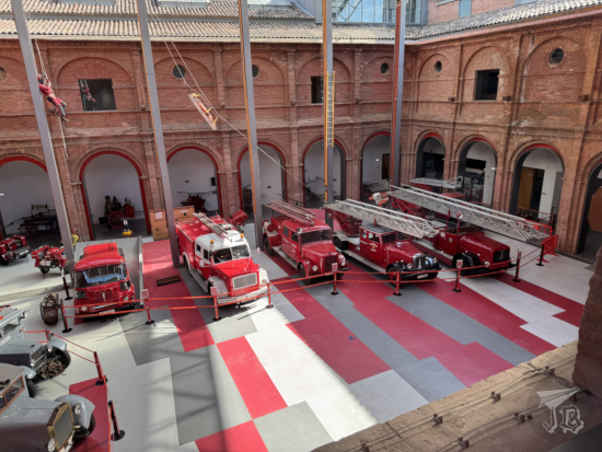
I continued towards the Fire and Fireforce Museum Museo del Fuego y de los Bomberos, where a nice gentleman wanted to give me a guided visit which I declined. Honestly, I just wanted to look at the old fire trucks (and actually, support any initiative by firefighters if it helps fund firefighting). It is a little quaint museum located in part of a former convent, the other half is an actual fire station. The exhibition covers documentation of historical Zaragoza fires, firefighting equipment, a collection of helmets, miniatures, and quite an impressive collection of vehicles used to fight fire. There were two immersive rooms, one which showed damage to a house and another about forest fires. I really enjoyed it, though I only had a quick visit – they closed in an hour, and I was the only guest along a family.
On my way back towards the hotel I walked by CaixaForum Zaragoza, where they were running the Patagonian dinosaurs Dinosaurios de la Patagonia. Seeing the Patagotitan on the balcony made me want to go in, but I had already seen it, and I knew I was just on a palaeontology high.
I headed back to the hotel – crossing a couple of quite unsavoury neighbourhoods – and bought some fast food dinner again. It was stupidly early, but after eating I could have a shower and relax on the bed while I studied the route for the following day. Furthermore, it was so hot I really needed that shower, and I knew I would not be going anywhere after taking it. Thus, I showered and plopped down to watch the Natural Science Museum’s YouTube Channel after I had learnt how to get out of the city.
For a while it felt that this day trip was cursed or something. Whenever I decided to schedule it, something happened – a family emergency, a weather alert, work hiccups, car trouble, you name it. I finally got everything ready on Friday and hoped for the best on Saturday morning. The weather was all right, family was okay, the car had passed its check, and work was calm for a minute. Off I went!
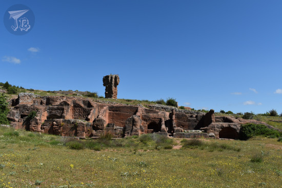
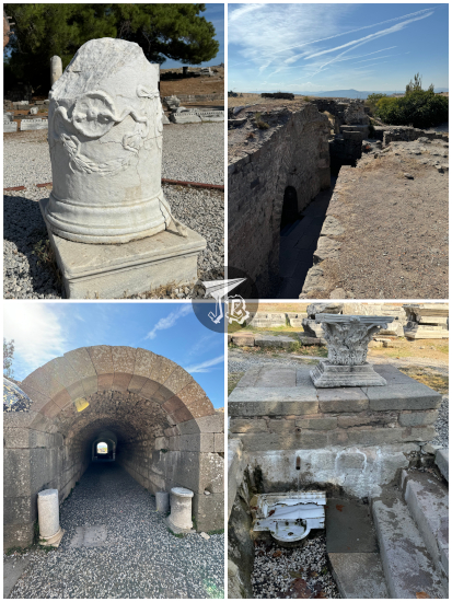
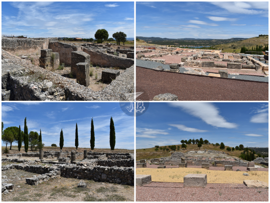
The Tiermes Archaeological Site Yacimiento Arqueológico de Tiermes is located in the municipality of Montejo de Tiermes, in the area of Soria. The ancient city of Tiermes was first inhabited in the Bronze Age. Before the Roman conquest, it was a Celtiberian dwelling, and during Scipio’s campaign around 134 BCE to conquer the Iberian Peninsula, it became an ally to Numancia. After the Roman Empire’s victory, the town was assimilated. In the year 98 BCE, Tiermes became a municipuim with two forums, a theatre, an aqueduct and several houses built to maximise the utility of the rocks of the area. In more recent times, a Romanesque hermit church was built nearby.
The site is located around 1200 metres high, in a sandstone landscape with flats and erosion cliffs. Both Celtiberian and Romans built around and into the rock, to the point that there are several “rock houses” which have been excavated into the mountain, with literal furniture carved out of the stone.
While the Romans made sure to keep the legend of Numancia alive – as it made the victory more glorious – Tiermes was eventually forgotten after it was abandoned, probably when the area ran out of water. The ruins were first excavated in 1960 by Teógenes Ortego and Juan Zozaya. It was however the work of José Luis Argente Oliver, between 1975 and 1988, which really brought out the ruins into the spotlight. There were new findings from 2008 onwards.
The drive was just shy of two hours, and since I left on a Saturday around 8:00, the roads were rather empty. I drove past the reservoir Embalse de Alcorlo, but the parking spot to look at the structure was behind a curve and I missed it. I also passed by the Medieval village Molina de Aragón, which had a festival the following day. I had an idea…
It was not extremely hot, and the drive was easy, even if I did not take the speedway. There was a stretch of the road which was really badly paved, and almost as soon as I drove into Soria it became pristine. I reached the parking area a bit before 10:00 – my Sat-Nav was way more on spot predicting the times than Google Maps. Though some of the roads had a speed limit of 90 kph, there was no way you could do more than 40 kph on them.
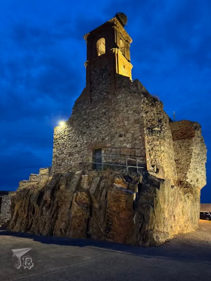
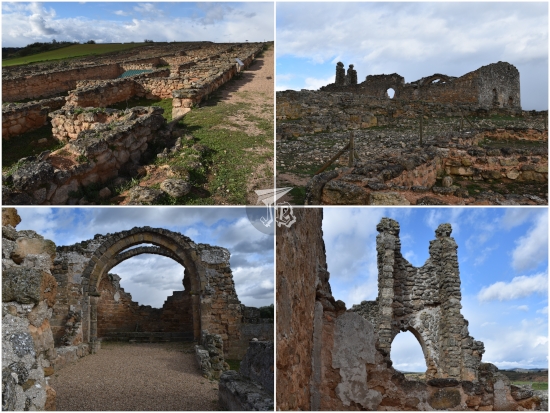
There is an area to park next to the hermit church Ermita de Santa María de Tiermes, the newest construction of the site, dating from the 12th century, which has a small cemetery associated to it. The little building looks like a 3D puzzle with its bricks and arches. It has a covered outer area, which indicates that at some point it was ready to receive pilgrims. Unfortunately, the church was closed so I could not snoop inside.
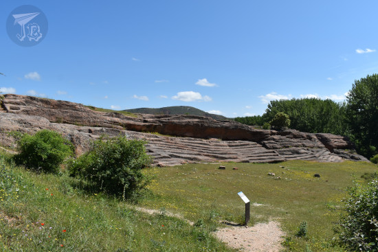
Instead, I set off for the walking route, which starts at the Roman forum. When the Romans took over the city, they transformed it according to their customs, and two forums were built throughout the Julio-Claudian and the Flavian dynasties (27 BCE – 68 CE and 69 – 96 CE). Most of the forum was erected above the ground and now it is gone.
The same happened to the House with the Aqueduct Casa del Acueducto, though in this case you can walk into the different rooms – and there are reliefs on some rocks that comprise the basements and foundations of the structure. The original house would have had 35 rooms in different levels, with stairs to move around them. The plinth was made out of the red sandstone that comprises the area and the walls were built with wood.
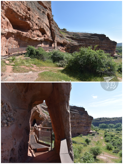
As Tiermes was partially built into the mountain, it has two levels. The upper one, with the forum and the Aqueduct house, and the lower one, where you can see (and enter) houses carved in the rock. I was on the upper part, heading towards the vertical wall to descend onto the lower area. In order to do so, I had to go down the West Gate of the city Puerta del Oeste, which now is just a small gorge between the levels, with a steep slope.
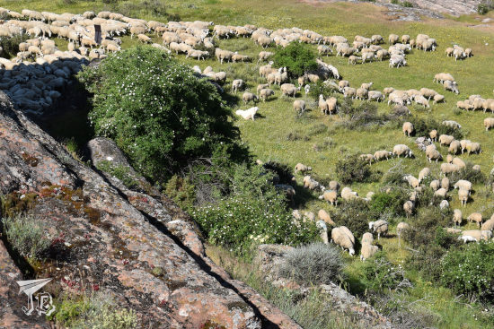
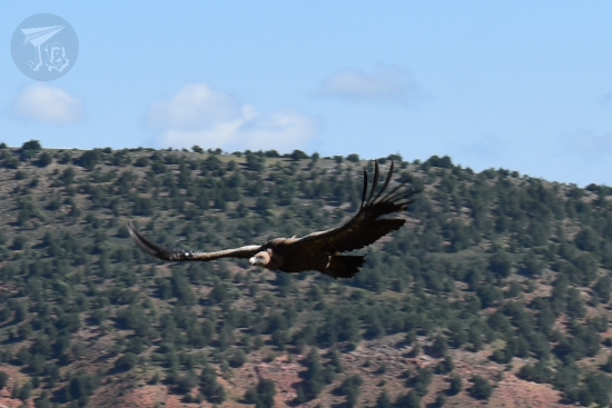
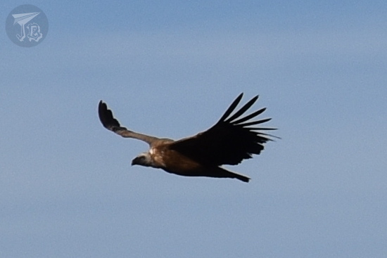
Whilst I was walking towards the Gate, I heard bells, and when I got to the edge of the rocks, I saw that there was a herd of sheep walking underneath, along a shepherd and five huge mastiffs. There was no way I was going to walk near the herd and bother the dogs, so I stayed in the upper part. One of the mastiffs gave out a warning bark, and at first I thought it was directed at me. However, I realised that the dog was barking at a couple of griffon vultures which were circling for any food available, namely if they could snatch a lamb, I guess. And then, one of the vultures decided to circle me instead of the sheep.
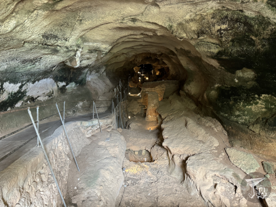
When the herd was at a safe distance, I went down and crossed the Gate to walk alongside the rock wall, which has houses carved into it. Not only that, there is a whole underground aqueduct Acueducto y Túnel de Tiermes dug into the rock. And you can actually explore its whole length! I went in. It was completely dark except for a couple of ventilation holes, and at the end of it I found myself at the Aqueduct House. I decided to backtrack using the same way in order to continue the route and not miss anything by accident, or because the whole experience was wickedly cool. Take your pick.
From the entrance of the aqueduct, I walked alongside the rock wall and explored the houses built into it – Casa de las Escaleras (The House with Stairs), actual apartment blocks up to seven floors, Casa de las Hornacinas (The House with Shelves) and Sección Rupestre Sur (Southern Area), which was built half into, half onto the rock. Most of these date from or were repurposed during the Roman area, so it is difficult to point the original Celtiberian work.
A bit away from the rest of the town stands El Graderío, an area with sitting terraces carved onto the rock that could have been a meeting place or a theatre. Then, I found another of the gates Puerta del Sol, which again gives way to the upper area.
There was also the reconstruction of the Roman wall, with… a couple of pieces of the original defensive wall, and a lot of new ashlars that looked quite fake, so you could see what was original and what was not. As far as archaeological sites go, though most of what can be seen in the town is Roman, it was cool to see so much standing – especially the aqueduct – considering how little of Numancia exists on site, though the reason is probably the constructions into the rock.
I got back to the car and backtracked a little to the museum Museo Monográfico de Tiermes. The small hall exhibits pieces of pottery and artifacts recovered from the nearby necropolis Necrópolis de Carratiermes – brooches, weapons, and other burial paraphernalia which are indeed Celtiberian. The museum was free since it was a weekend.
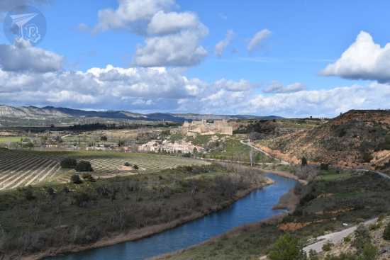
On the drive back, my Sat-Nav made a weird noise. It speaks everything except… Well, route changes. It decided to propose a different route, that is what the sound meant. I think it’s a new update or something, because it had not done it before, and it has a couple of items since then. As I could not check it – it was not safe – I missed my turn for the easy secondary road and had to take an alternative route. I ended up in Jadraque.
While it is true that the castle Castillo de Jadraque is amongst the places I need to visit at some point, it was high noon. Too hot, even if you can drive nearby, for a castle which is closed for restoration. I’d rather wait till it is reworked. I did stop at a viewpoint for a couple of pictures.
Not long afterwards I found my way to the highway and it was easy to get home from there, though I do prefer the secondary road to all the lorries in the highway. I got home by lunchtime to wait out the heat and have a post-hike lunch.
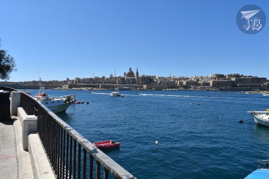
It was my last day in Malta. My return plane was mid-afternoon, so I had to head towards the airport at noon the latest. For that morning, I had planned a leisure stroll along the beaches towards the east of Saint Julian’s | San Ġiljan and Sliema. I had breakfast, grabbed my backpack, and set out along Ballutta Bay, Exiles Bay and St Julian’s Bay.
There is a watch tower at the edge between both towns Saint Julian’s Tower | Torri ta’ San Ġiljan, built to protect the bay in 1658, though today it is a restaurant. After looking at the waves for a while, I walked along the coastline until I found the Roman Baths, which to my disappointment, are not Roman but Victorian artificial pools, from the time Malta was a British colony – they were upfront about this though, unlike the Birżebbuġa ones.
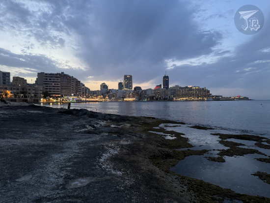
I can look at waves for hours, and that’s exactly what I did. I passed by Sliema Point Battery (now also a restaurant; I would have liked to try it to be honest, just because it looked cool) and eventually reached the Sliema Promenade. There, the scenic ferries leave to take tourists around the bay, and the actual ferries sail off to Valletta, which can be seen across the water from the Panoramic View Of Valletta point. There is a cute little building, the Sea water distilling monument, the remains of Malta’s oldest water distillation plant, used after its construction in 1881 to provide drinking water to the population. Fresh water was obtained by boiling sea water to separate the actual water from the salt.
I still had a little bit of time, but I was next to the correct bus stop, and it was almost time for it to pass. Thus, I decided to take it, get to the airport, grab a coffee, and visit the Observation deck.
As I stopped by the airport’s Costa Coffee I got talking to a couple who had just landed and were figuring their way out after a change of plans. When they heard I was going home, they immediately asked where my next adventure was. I found it both endearing and hilarious – do I look that travel-minded? I should have told them that I planned to go dig dinosaur eggs or something…
I drank my vanilla latte at the Observation deck, then I went through Security and checked the book shops for a copy of The Little Prince in Maltese for my parent. I found a quiet place to sit – and damn it was freezing, so I ended up wearing all my layers until I boarded the plane.
In the end, I carried my bathing suit for nothing, but I have to admit that despite the inconveniences on Saturday, I had a blast in Malta. While it had never been on my radar as a potential destination beforehand, I am really glad I chose it. I did not miss having a car, because the public transport was convenient enough, and the weather was superb. Gozo was not as spectacular as I expected, but I wouldn’t mind coming back to the country to explore the rest of the temples – especially the Ħal Saflieni Hypogeum – and the one main city I did not visit – Mdina. Next time around though, I don’t think I’ll book any tours and organise everything myself. Given some time, I think I can make a great itinerary for a second visit. Oh, and I will try to find a hotel in a non-party area or destination.
The group of drunk people was back again, at 5:00 once more. Joy. However, this time I could not get an early start because I had booked a Megalithic Tour with a company called Visit Malta, as at first it had felt more convenient than navigating the buses. They confirmed and sent me a ticket saying that pick up was at my hotel, and a Google Maps link that did not work. Thus, I assumed that they would pick me up at the hotel. I tried to contact them via email previously, but I had no reply, so I told myself not to be paranoid, and trust them.
Twenty minutes after the pick up time, I called them. They yelled at me that I was in the wrong place. I informed them that my ticket read “pick up at the hotel”. They told me there was nothing they could do for me. So I was upset for about 3 minutes – that was 50 € down the drain. However, it was only 9:30 in the morning, so I had time to take matters in my own hands and go see the temples on my own. And I could even squeeze an extra one! I felt… I don’t know… gleefully spiteful. I was going to see the temples out of revenge! I know it sounds strange, but it took me back to what happened in Cappadoccia, when there was nothing I could do to fix the issue. This time around, I had lost some money, but I would not miss on the experience.
Of course, this would have been much more efficient if I had organised the visits originally on my own, since the Ħaġar Qim and Mnajdra Archaeological Park | Il-Park Arkeoloġiku Ta’ Ħaġar Qim u L-Imnajdra is in Qrendi | Il-Qrendi, quite close to the Blue Grotto. Conversely, that also made it easy for me to get there, since I knew the bus route already. But I decided not to dwell on the inconvenience and just “save back” the lost 50 € back not buying whims or mementos.
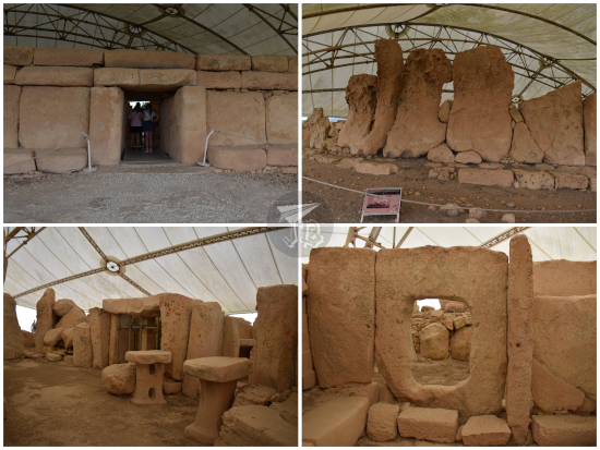
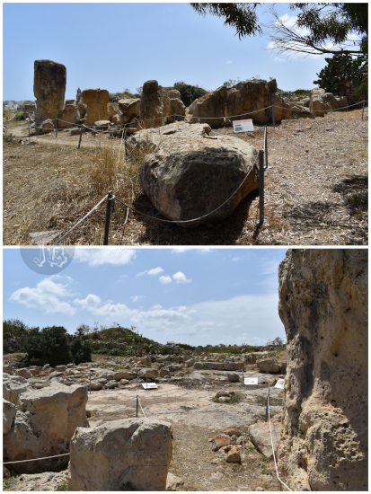
The Megalithic Temples of Malta are a World Heritage site, and it still blows my mind that they are older than either Stonehenge or the Giza Pyramids. The Ħaġar Qim and Mnajdra Archaeological Park | Il-Park Arkeoloġiku Ta’ Ħaġar Qim u L-Imnajdra might be the most well-known complex, or at least it was the one with most tourists.
The temples Ħaġar Qim and Mnajdra are located very close to one another, and they share an entrance with a small museum, thus forming one archaeological park. Both were first officially described by officer J.G. Vance of the Royal Engineers (British Army) in the 1840s. Unlike Ħal Tarxien on Thursday evening, these two were packed with visitors – more than a few of them happily touching the stones out of curiosity or for support as they walked. I got there in bus 201 and reached the entrance just before a big tour bus entered. The guide lady tried to go past me, but my face must have told her that I was not in the mood to be messed up with, and my turn was respected. The museum mostly had information about the environment, and pieces of pottery that had been recovered from the sites – similar to what the Archaeological Museum in Valletta.
Ħaġar Qim was erected using the ever-present globigerina limestone, a soft sedimentary rock, golden in colour, formed around 23 – 14 million years ago. As this and other temples have weathered out, they have taken a more reddish or brown colour. To protect the remains from deterioration, many have been covered with protective tents.
The temple has several inner chambers within a retaining wall that can be crossed through a trilithon. The whole site has a keyhole shape, and it has been associated with fertility rituals. The main temple was built between 3600 and 3200 BCE, with remains of older ruins. As construction went on, the shape became distorted. It holds the largest stone in any of the Maltese temples, and an altar probably for animal sacrifices. It was hard to get into the magnificence of the temples with so many people swarming them after the Ħal Tarxien experience. However, the structure is quite impressive in itself.
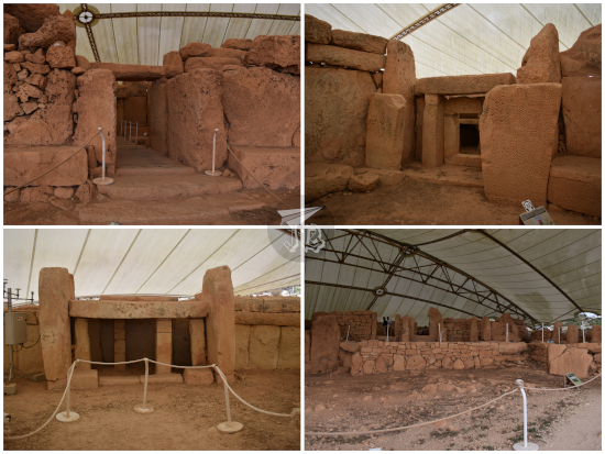
Mnajdra | L-Imnajdra is made from coralline limestone, a harder kind of stone, so as a construction material, it can be used in smaller blocks. Mnajdra might be the most representative temple in the archipelago, as its altar is depicted in Malta’s 1, 2 and 5-cent coins – though it is not the one which kickstarted the Unesco protection. Mnajdra consists on three temples arranged in a clover-leaf disposition. The structures are joined but not connected. They were erected between 3600 and 2500 BCE – so they could be over 5,600 years old. Even with the sheer amount of people around, there was something special about the complex. The temple plays light tricks on the equinoxes and solstices, and the decoration of one of the stones could be interpreted as a lunar calendar (with a lot of imagination, if you ask me). Probably, out of all the temples I visited, this one was the one I found more impressive – even if the first one I saw will forever remain my emotional-favourite.
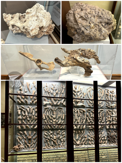
I was done before schedule, so I went back towards the bus stop. I returned to the airport and then took another bus (119) to Birżebbuġa. There I could see the Għar Dalam Cave and its museum. The Cave is home to some of the oldest evidence of human presence in Malta, around 7,400 years ago (the oldest comes from Mellieħa Cave, dated as 8,500 years old). Għar Dalam Cave is about 144 metres in length, and it also contains remains of animals that have been long extinct in the island, found in distinct layers of sediment at the bottom of the cave.
There is a base layer of clay, older than 167,000 years. Over that lies the “Hippopotamus layer”, showing remains of two extinct species of hippopotamus, deer, dwarf elephants… One of the hippos, Hippopotamus melitensis, was a “dwarf” hippo (only 900 kg) endemic to the island. The remains are very mineralised (almost fossils) and worn down. This is also called the “Breccia layer”. Breccia is a rock composed large angular fragments of minerals cemented by a fine-grained matrix, only in this case the fragments are ancient hippo bone.
Covering the “Hippopotamus Layer”, there is a band of pebbles, without any remains. Over that one lies the “Carnivora Layer”, with remains of several of the previous animals along with foxes, wolves, bears, and smaller creatures such as voles, shrews, bats, turtles… These range from around 167,3000 to 151,200 years ago, and are less mineralised and worn down, just like the following band: the “Deer Layer”. Here there are remains of three different species of deer, some bovines, equines, and small animals. The two upper layers, starting 7,200 years ago, hold remains of small wild animals, domestic animals – sheep, goats, pigs, cows and cats – pottery and other human artefacts, and human remains.
Għar Dalam was first investigated in 1865 by palaeontologist Arturo Issel. Subsequent researchers expanded the excavation and knowledge, identified an all-new species of dwarf hippopotamus, and systematised the museum adjacent to the Cave. Said museum, called the George Zammit Maempel Hall presents hundreds (thousands, maybe) of the remains dug up from the cave. However, the most important ones, amongst them the skull of a Neolithic child, were stolen in 1980. The Cave itself is creepy and damp, and the excavation shows the different layers for the spectator to see. One wonders what lies beneath the end of the visitable area… I would believe the cave be haunted much easily than the Grand Master’s Palace.
Across the valley from the Cave, you can see the remains of a ruined Roman villa Ta’ Kaċċatura, but it cannot be reached, and it’s hard to distinguish rocks from the actual ruins.
By now, I had seen all the temples included in the original tour, so I had a bit of a victory moment. And yet, I had more to do. I loaded up on sun lotion, then headed towards the nearby Borġ In-Nadur, barely ten minutes away on foot – plus some extra to cross the street so you are on something similar to a pavement to walk on. Borġ In-Nadur is another small megalithic structure, with a cemetery, and the remains of a Bronze Age village, with remains ranging from the years 3000 to 700 BCE. Entrance to the Megalithic site was included with the visit of Għar Dalam. The temple was first excavated in the 1920s by archaeologist Margaret Murray. It is the most dilapidated site I visited, but I was again alone – except for a couple of chickens from an adjacent farm. You are allowed to go into the niche or stone circle, and unlike the other temples, it is not covered (yet?).
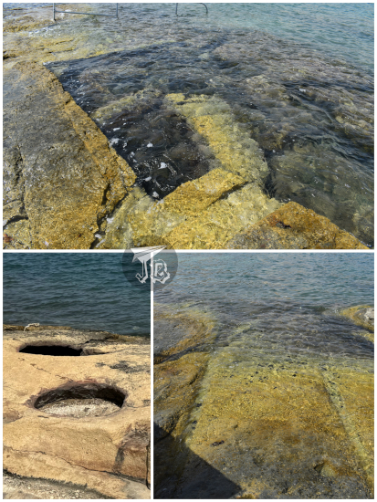
Near the temple, at the limestone beach of St George’s Bay | Il-Bajja ta’ San Ġorġ, I found silos and cart ruts, also thought to date from the Bronze Age, and Roman Baths directly carved into the limestone. They are not really Roman baths, as in dating from Ancient Rome, these are artificial pools were excavated into the rock during Victorian times. And yet modern people think they’ve invented something…
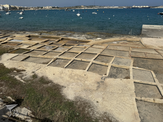
Not far from there, I found the bathing beaches, the commercial harbour and the salt pans, a traditional way to produce salt letting sea water evaporate from shallow pools in order to harvest the salt crystals. They did not seem in use though as they were either full of litter or used as sunbathing spots.
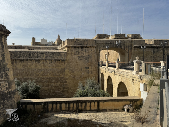
I still had some time and energy, and decided to invest them on getting to Birgu. This Medieval city is located across the Grand Harbour from Valletta, and it was the first place where the Knights Hospitaller settled. It has a bunch of historical palaces and museums. I would not get there before closing times, but at least I could see the town layout and some buildings from the outside. These included the Gate of Provence, the Inquisitor Palace, the Birgu Waterfront and Maritime Museum, and finally Fort Saint Angelo, a key fortress during the Siege of Malta. Today, use of the fort has been granted to the modern version of the Knights. There was a sign reading “Jurassic World: Dominion” was filmed here, but I did not recognise the backdrop.
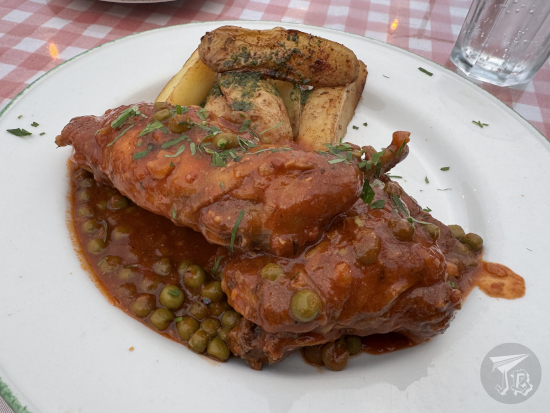
I found a convenient bus to head back to Saint Julian’s | San Ġiljan. I freshened up and headed for dinner. At first, I tried to get a table at a restaurant right at the entrance of the hotel. Since they decided to ignore me and give the table to someone else, I moved along. I found Salt & Pepper, a nice grill with an ocean view and an outdoor sitting area. There, I was able to try Stuffat tal-Fenek (fried rabbit in garlic), a typical Maltese recipe (considered the national dish, actually) – pan fried rabbit, simmered in wine, tomato paste, garlic, peas and olive oil, served with roasted potatoes. I wanted to try it, but at the same time I was a bit reluctant, as I am not a big fan of neither garlic nor wine. In the end, I have to say I enjoyed it more than I thought (as long as I kept my mind away from it being actually… rabbit).
Afterwards, I walked around Spinola Bay for some nice views before I turned in for a shower and some sleep… only to be woken up at 5:00. Again. But hey, this time it was a group of girls.
My flight departed at 9:55 from Madrid-Barajas, which is actually a very bad time for a flight, as you have to drive to the airport through the daily rush-hour traffic jam. However, for a change, I was given a lift there instead of driving myself – my car failed a few days before and I was not feeling too trusting. The inbound plane was delayed, and we ended up landing at Malta International Airport around an hour late.
It turns out that Malta has done a smart thing – the airport is also a coach hub, and there was a bus which went directly where I wanted to go first 20 minutes afterwards – that was lucky because the bus only comes every hour. It did not take long to reach the Blue Grotto | Taħt il-Ħnejja in the village of Qrendi | Il-Qrendi.
I got off in an aptly-named bus stopped called Grotto, next to which stands Xutu Tower | Torri Xutu. The history of Malta cannot really be understood without mentioning the Order of Knights of the Hospital of Saint John of Jerusalem, the Knights Hospitaller, today also known as the Sovereign Order of Malta. This Catholic military order was founded during the Crusades in the 12th century and the knights were established in Malta between 1530 and 1798, acquiring the name. They fortified the island and created the city and defences of Valletta, so-named after Grand Master La Valette. The knights built hospitals – along with medicine schools – and turned Valletta into a centre of art and culture with a university, a school of navigation, and a school of mathematics. Through the centuries, the order transitioned from a warring and defensive army to an organisation centred in humanitarian, medial and social assistance.
Xutu Tower | Torri Xutu was one of the towers built during the operation to fortify the coastline of Malta, probably around 1650. It is a two-story tower with a square ground plan and vaulted ceilings inside, setting the example of the towers that would be built afterwards. As many buildings in the island, the tower was erected using limestone, and restored in 2014 using the same type of material. It also yields to impressive sights – even without climbing it – of the ocean and the islet of Filfla, uninhabited and turned a bird sanctuary.
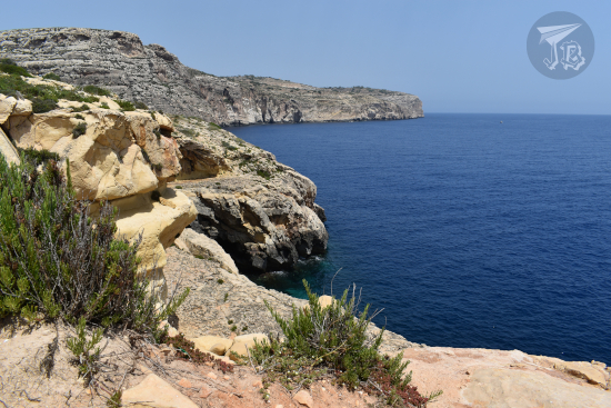
I bought a ten-euro ticket to sail to the Blue Grotto | Taħt il-Ħnejja from the Blue Grotto Boat Service. This is just a way to amalgamate all the captains and boats who do trips to the caves, I think, and not a bad one. It is a quick trip that does not even take half an hour and charters you to snoop the different caves, created by the erosion of sea water and waves against the cliffs. Each has its name: Blue Window Cave, Circle Cave, Calscave, Honeymoon Cave, Cat’s Cave, Reflection Cave and the main archway which gives the name to the whole area, the Blue Grotto. The water is very clear and since the sun was out, there were extremely beautiful reflections. I stuck my hand in the ocean a few times when I was not taking pictures.
Afterwards, I decided to stop for food. I was not really hungry, but I wanted to tackle the walk to the viewpoint, which was 15 minutes. I thought it would be more efficient to have a late lunch first. There were a couple of restaurants and I chose Step in Malta. It had a terrace, was less than half full, and most importantly: offered calamari fritti. When I researched Maltese food, I read about this dish – fried squid with garlic and parsley mayonnaise, and I really wanted to try them. I think I broke the poor waiter’s brain when I told him I did not need the menu and ordered directly. They were delicious.
I then did the short walk to the Blue Grotto Viewpoint – and though I won’t be mentioning it much, just assume I just used a lot of sun lotion all the time. It did not take as long as I expected, even if the shortcut was closed down. It yield to pretty views, but not as impressive as expected.
I was about to go back towards the original spot to wait for the 201 bus again, when a Valletta-bound bus stopped by. I hopped onto that one to use the Wi-Fi and replan the rest of my evening. An idea had been to head towards Valletta indeed, but instead I decided to try my luck to reach my first Megalithic temple in Tarxien | Ħal Tarxien. The Blue Grotto is actually quite near another archaeological complex, but that one was covered by the tour I had booked on Saturday.
The trip to Tarxien turned out to be a great idea. When I arrived, I was surprised by the sheer amount of Christian images that were in the streets. That weekend the Catholics celebrated the Feast of the Annunciation. Malta is officially a Catholic country with over 80% of the population adhering to the religion, so while it was slightly surprising to see so much decoration, it is not shocking. I wanted to get to the Ħal Tarxien Prehistoric Complex | Il-kumpless Preistoriku ta’ Ħal Tarxien because it had a closing time.
The Megalithic Temples of Malta are considered amongst the oldest free-standing structures in the world. They were erected between 4100 and 2500 BCE (making them older than Stonehenge, whose rocks were placed between 2600 and 2400 BCE), though the remaining structures probably date from the 3600 – 2200 BCE. In 1980, the UNESCO created the Heritage protection for one of the temples, and in 1992, the Site expanded to six temples / structures in total.
The Ħal Tarxien Prehistoric Complex | Il-kumpless Preistoriku ta’ Ħal Tarxien has been dated between 3000 – 2500 BCE, and it is considered the greatest example of the Temple Period (4100 – 2500 BCE). It was first excavated by Maltese archaeologist Themistocles Zammit around 1913 following complaints of a local farmer that he kept hitting stone while ploughing. The main excavation and restoration took place between 1915 and 1920, and some of the most delicate structures were moved to the Malta Museum of Archaeology to protect them from weathering. The site is covered by a protective tent that makes it look a bit alien, and being alone made it even more magical.
The temple is built in limestone, showcasing three constructions which are independent but attached to one another. The rooms are round, and there is evidence that they had a roofing. There are several chambers, and in some of them there are spiral decorations and domestic animals carved into the rock. There is even a small hearth where fire could be lit. I spent about an hour there, nearing closing time, which meant I was almost alone. I was extremely happy to be there.
I could not visit the related Hypogeum of Ħal-Saflieni because tickets are released – and sold – months in advance, and this whole trip was planned in a couple of weeks. But I could explore around.
Due to the festivities, some of the bus stops were out of order, so I followed the bust route until I found one that was in use. At some point there I crossed my first “invisible frontier” between the village of Tarxien and Paola. Still in Tarxien, I stopped to look at the Catholic sculptures, and in Paola, I came across the Minor Basilica of Christ the King | Il-Bażilika ta’ Kristu Re. The church was erected at the beginning of the 20th century and, compared to the buildings around it, it feels huge – over 80 metres long, 40 metres wide and 60 metres high. It was full, which I found strange for a weekday at 18:00, but then I thought it might be part of the Feast of the Annunciation programme.
I took a bus again and after a few changes I reached my hotel in the town of Saint Julian’s | San Ġiljan. Though I was driven through a few towns, it felt like a huge stride of buildings one after the other, with no real break. It was weird, that the whole area is just one big urban sprawl. I found changing buses easier than I expected, even not knowing the layout of the area. I got to my stop, Ballutta and checked into my hotel.
Aaand at that point I realised that there was a consequence of “British colonisation” that had not even crossed my mind – Malta has Type G plugs. So on my supermarket run I had to add an adaptor (despite having a few at home) to my bottled water and sandwich shopping list. I dropped the groceries at the room and then I went off to explore the coastline. That way, I inadvertently crossed to Sliema. I walked along Ballutta Bay and Exiles Bay, two of the three lobes that make up the larger St Julian’s Bay. I was a bit surprised when all the beaches were made of rock and limestone, which made them great to walk on. I had a lovely walk – except at one point, when I slipped and realised that my totally-sensible-for-airport shoes were not the best choice for limestone beaches. Eventually, I went back to the hotel to eat my supermarket-bought dinner.
We left around 8:00 towards Pergamon Ancient City Pergamon Antik Kenti, another of Türkiye’s World Heritage sites – Pergamon and its Multi-Layered Cultural Landscape, still in the city of Izmir | İzmir (in Türkiye, “city” and “province” are interchangeable, apparently). The origin of the city dates back to the 8th century BCE – though there were legends about a mythological foundation by the son of Heracles. Pergamon flourished and became the capital of its own kingdom, until it eventually fell in Roman’s hands. The most important archaeological area is the acropolis – though the Great Altar, which is currently located in the Pergamon Museum of Berlin, in Germany. I had had a tired / silly moment the night before and packed the camera battery charger with the battery still in it, and I almost had a heart attack when the camera would not work. Fortunately, it made a lot of sense after I opened the battery receptacle.
We did not get to go to the Upper or Lower Acropolis, but we could see the theatre, one of the steepest theatres in the world – built in the 3rd century BCE with capacity for about 10,000 people. We stayed down at the foot of the acropolis, in the Sanctuary of Asclepius Asclepieion [Ἀσκληπιεῖον] – a healing temple dedicated to the demigod Asclepius, the demigod who learnt the art of medicine from the centaur Chiron and became the first doctor in “history”.
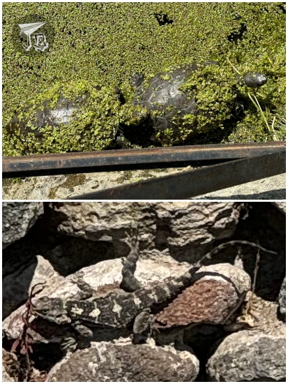
The Asclepieion worked with a holistic approach to patient care, giving thought to tranquillity, water, and activities such an art and theatre performances. The theatre is one of the best-preserved structures in the Asclepieion of Pergamon, though there are many others – such as 70 metre long cryptoporticus a tunnel that connected the baths, sacred pools – with a healthy population of frogs and tortoises – and fountains. I also found a lizard chilling out – or baking out, considering the temperature (remember, I had packed for… autumn, not for almost 30 ºC at noon every day…). Some famous ruins include
I wandered around for as long as I could, but again here was no time to explore everything – though this time I came pretty close. We left at around 12:30. This was the only visit we had on the day, as we were directly driven to the hotel in Çanakkale. On the way, we saw the Red Basilica Kızıl Avlu just before leaving Izmir, and glimpsed the island of Lesbos from the bus.
Iris Hotel was in the middle of a residential area – to the point that the bus barely passed through some of the streets. There was nothing interesting around to see in kilometres, so to… compensate, I guess, the hotel had a small mini zoo of deer and fowl.
Behind the hotel there was a private beach with a stunning sunset, but nothing around to explore or do. Çanakkale is located to the west of Türkiye, at the end of the Dardanelles Çanakkale Boğazı, the natural straight that joins the Aegean Sea with the Sea of Marmara, just south of Istanbul. The sea was warm, but I only got in up to my knees. At night, I watched a monster movie in Turkish. That… was an experience.
It is not paranoia if they are really after you. And I am paranoid enough not to set a foot onto a bus before I make sure my suitcase is on board with me. So, guess who had to wrangle their suitcase down the stairs, since the hotel staff did not do it? Yep, I did. At least down is easier than up. Anyway, we were our merry way by 9:00, and continued until noon, when we were ushered into a “typical fur-working centre” which was… I don’t know how describe it, to be honest. But neither typical nor traditional are words I would use.
First, we were taken into a room with a catwalk and given notepaper to write down the numbers of items we liked. For about an hour, four or five models showed off anything but typical leather items, a lot of them reversible. Then, we stepped into the shop. I touched some of the items – they were extremely thin and weightless, which was weird. The prices were extremely high, too, even taking into account “the 70% discount because we were special”. I am happy to report I was at no point approached by any salesperson – again, maybe I do not look targetable to Turkish people?
Lunch was okay, it had some nice dips and a soup, then another sad-meat main dish – albeit with your very own pita bread! Dessert was the only one I liked – a churros family treat called tulumba.
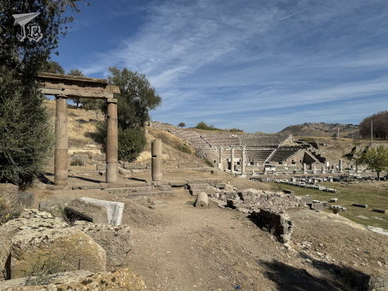
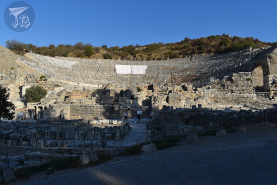
Afterwards, we continued onto our way to Ephesus, which belongs to the current settlement of Izmir | İzmir, and is an archaeological site considered World Heritage. Coincidently, it was more than warm. It was scorching. We were there for two hours and a half, from 14:30 to 17:00. Again, leaving way before closing time to reach the hotel around 17:30, and yet this was the archaeological site where we spent the longest!
Ephesus was a city in ancient Greece – which back then included several areas of what is now Türkiye. Ephesus was founded around the 10th century BCE, and it became home to one of the Wonders of the Ancient World, the Temple of Artemis, which was built around 550 BCE. It was controlled by the Romans between 129 BCE and 395 CE, and during this period, it became an important site in Christianity starting the year 50 CE or so – with the apostle Paul of Tarsus living there, and reportedly being home of “the seven churches of the Apocalypse”. The city suffered attacks from the Goths, and was damaged by earthquakes before being finally abandoned in the 15th century.
Though the temple of Artemis was off-site and it has been destroyed, many monuments from different periods still stand or have been restored. There are two theatres, a small odeon, and a larger one – with the large one being probably the greatest in the ancient world, seating 25,00 people. There were two agoras, one for commercial meetings and the other one for business. During the Roman times, the Gate of August was built to honour the Emperor.
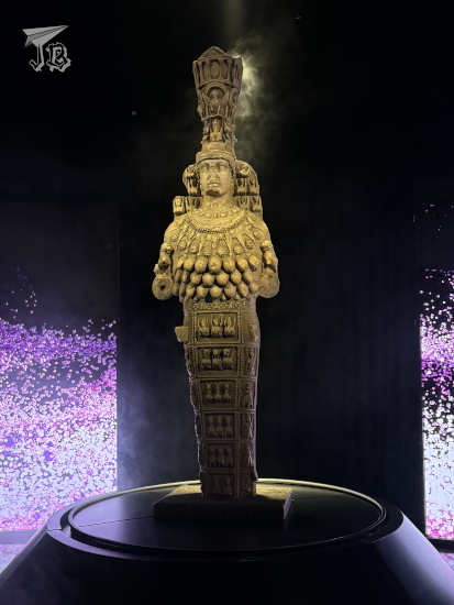
Since the temple is long gone, the most important building remaining is the Library of Celsus, rebuilt from the pieces left. Tiberius Julius Celsus Polemaeanus was one of the Ancient Greek governors of Roman Asia, who paid for the library himself around the year 125 CE, and is actually buried underneath. The library once held up to 12,000 scrolls in 180 square metres.
The guide kept hurrying us up, saying that he had a surprise for us – which turned out to be an immersive show about the history of the city, and after that we had to leave. The film was okay, but I would have much preferred to have more time to wander and see the real thing. The only item that was real – I hope, though it was probably a copy – was the final statue of Artemis.
We left afterwards. We did not get to stop by the place where the temple used to stand. We did not see one of the most famous sites outside the city either – the so-called house of the Virgin Mary because, according to the guide, “it was a recycled myth”, it was probably the house of Artemis’ priestesses. Which in my view made it even more interesting, but oh well…
Ephesus Hitit Hotel had an outdoor swimming pool that I dipped into, but it was too cold to stay for a long time. I also tried to go out of the hotel to find something to see, but the street did not seem safe. To the point that our bus driver actually saw me going out and came to ask me if I was all right…
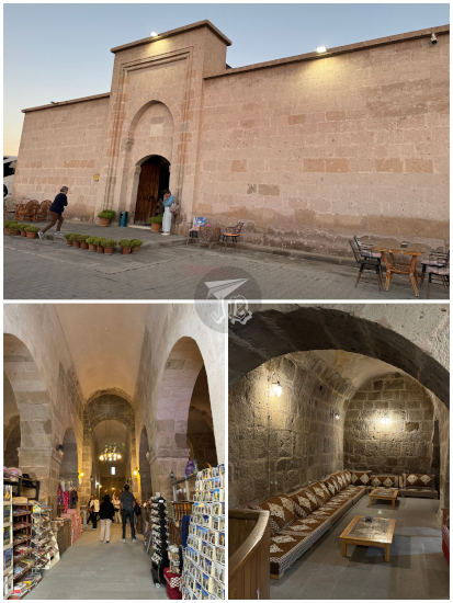
Upset as I was, it took a long time to fall asleep, and I nearly had a heart attack when the hotel’s automatic wake-up call made the landline ring at 4:20 – half an hour before my alarm clock was set. We left around 5:40, and it was cold at that time, though it would get really hot during the day. Around sunrise, we reached our first destination – a caravanserai (kervansaray in Turkish, کاروانسرای, kārvānsarāy], in original Persian). Between the 2nd century BCE and the 15th century CE, Europe and China were communicated through the Silk Road, a network of trade routes frequented by caravans. Caravanserai were roadside inns built alongside those trade routes. They were fortified inns which protected the traders from bandits and weather, providing food and water. In Turkish, they are also called han.
Öresin Han (also called Tepesi Delik Han, “the han with a hole on the roof”) is a restored caravanserai / han. It was built in 1188, according to a plate that was recovered during restoration. The works lasted between 2007 and 2010, saving the building from literal ruins (and the aforementioned hole on the roof). Nowadays, it is a shop and inn for tourists. It has thick walls and a vaulted interior to withstand the weather and possible attacks.
We continued on the road for hours until an early lunch at noon, then drove to the World Heritage Site Hierapolis-Pamukkale, a combination of historical site and geothermal activity. First and foremost, there is the travertine formation. Travertine is a sedimentary rock made out of calcium carbonate which precipitates from fresh water – basically, the material stalactites are made of. Sometimes, in thermal areas, they deposit in cascade form with lakes and waterfalls.
The Pamukkale travertine formation Pamukkale travertenlerinde is a terrace formation around 2,700 metres long, 600 metres wide and 160 metres high. The local thermal water oozes onto the surface at a temperature between 35 and 100 ºC and saturated with calcium carbonate. At the surface, carbon dioxide degasses and the calcium carbonate precipitates into a gel that will crystallise into travertine. Unfortunately, the waterfalls have been mostly drained now to feed pools at the hotels.
Even from the Classical era, the travertines have attracted visitors to the point that a thermal spa was founded around the 2nd century BCE, which eventually became the town of Hierapolis. In the year 133 BCE, Hierapolis was incorporated into the Roman Empire.
We had some time to wander around the place, but way too short to actually see even a quarter of what was on display, which was frustrating – but this would again happen at every archaeological site. Along one of the nice ladies from my group, I saw the Roman baths, then basilica, now museum, which contains the smaller items unearthed – sculptures, friezes, sarcophagi. We then climbed up to the Temple of Apollo Apolion and the Temple of Pluto Ploutonion – which are closed off as the cave underneath them emits asphyxiant carbon dioxide due to the geothermal processes.
There is also a swimming pool on site, and after hiking up to the theatre it might have even been inviting, if not for the fact that you could actually step onto an area of the travertines to experience them first-hand. I of course took the chance, and was surprised at how… non smelly it was, used to sulphur thermal waters in Japan.
I did not understand why we had to leave so early, because then we just ended up at another hotel with nothing around – thinking back, I have reached the conclusion that the guide was overworked, and he kept a schedule of going to sleep early and getting up early too, that is why we were at all the hotels at 18:00 at the latest; not an excuse, but an explanation. We were at Colossae Thermal & Spa Hotel around that time. The hotel did not have a lift, and most of our rooms were on the first floor. The hotel staff brought the luggage up, and we were reassured it would be taken down again the following morning. I… had a feeling it would not.
In accordance to the thermal and spring water reputation of the region, the hotel had a thermal centre. It comprised a swimming pool, a warm pool and a jacuzzi inside. Outside, there was an actual thermal water / mud pool – which was great for relaxing, but at 33 ºC, I could not stay for long (and I tried not to feel guilty as I knew the water is deviated from the travertines). By this time in the trip, too, I had inserted myself into a group of nice people, and made acquaintances with a nice couple, which was good because it’s always useful to have someone telling you that you’re about to get into the shower with your glasses on…
I had made a thing out of two coffees for breakfast, and today was no exception. The whole group was now in the hotel so we were ready to go see the sights. The bus had barely hit the road when our guide gave us a huge grin and decalred “I’m the first Turkish face you meet during this trip. Trust me. We’re going on the balloon is too expensive, so we’re not gonna do it here. We’re going to do it somewhere else”.
I was crushed at these words. Had he said this the previous day, I would have arranged to go onto the balloon on my own – today. Now, with a 5:00 departure time the following day, it was impossible. I don’t have words to write how I felt – devastated, cheated, furious. The option to ride a balloon in Cappadocia was in the documentation, and I had budgeted for it. And this guy had plain and simply… robbed me from it, because he did not want to wake up early after picking the other half of the group from the airport. Looking back, I should have tried to do it myself, hiring the flight on the hotel for today – and knowing that does not make it any better, because I could not do this one activity, which was important for me, not because of the weather or any actual problem. Just because the guide did not want to do his job. I did try to get him to reconsider, but he was like “no can do”.
Thus, I reached the conclusion that the travel agency, Oxin Travel and the guide himself sucked. Through the day (and the rest of the trip), I would build evidence on this – such as hearing explanations that did not make sense, or just contradicted what was written on the panels. I’m surprised it did not cross my mind to leave the trip at that time, because I was seething and heartbroken. In the past, I have tried to leave unsavoury experiences out of JBinnacle, but this would not be an honest trip report without all the emotions that coursed through me during that day – and to be honest, this was just the beginning of the problems. I wrote an email to the distributor that very same day, told the guide, and have complained formally to my travel agent. I have no hope for any solution, but at least I made it known that I was not happy with the services provided. And this trip was not cheap, at all.
I had to try to get over the disappointment in order to at least see what I could of the region. It was hard, I felt a cloud over my head ruining the mood. I almost did not care about anything else, but I knew I had to make do with what I had, or let my whole trip be ruined. Thus, I tried to get myself into the right mindframe to enjoy the World Heritage Site Göreme National Park and the Rock Sites of Cappadocia as much as I could.
Around 9:00, we reached Christian Keşlik Monastery Keşlik Manastırı outside the town of Ürgüp, which is a cave monastery. Human history in Cappadocia is tied to its geology. Tuff is easy to carve, and a lot of civilisations have made their dwellings into the earth instead of on it. First, it was the cavemen, and much, much later the Christians. The first buildings from the monastery date back from the 3rd century CE. Between the 1st and the end of the 4th centuries CE, Christianity spread through the Roman Empire, coming into conflict with the established religion, which deified the Emperor. As Christianity forbade idolatry, their refusal to adore the Emperor as a god made them a target of persecution, accused of treason. In some Roma cities, the Christians took to the catacombs. In Cappadocia, they dug cave monasteries.
Within the tuff structures, ancient Christians created all the items that one would find in a regular monastery – a church, two actually, St. Michael and St. Stephen, a refectory, a winery, dwellings, a baptistery created from a sacred spring… The monks could perform their rituals and protect themselves from any possible attack. It was a functioning Orthodox church well into the 20th century.
The most important cave-building in the rock is the Church of Saint Michael. Its ceilings are decorated with black backgrounds and colourful figures, although many were damaged by iconoclast movements. There were also tomb-like structures where the monks meditated. Underneath the church, there is a baptistery, and next to it the refectory, with a long table and seats carved out of rock. Outside, you can wander around the dwellings, halfway between caves and houses, which served as rooms for the monks.
Afterwards, we headed out to the Underground City of Mazi Mazı Yeraltı Şehri, known in the past as Mataza. There are between 150 and 200 known “underground cities” in Cappadocia. They were initially carved between the 8th and 7th century BCE by the tribes which dwelt in the area. Turf is easy to carve and there is no water in the soil, which made it easy for the tribes to dig “caves” under their houses. These caves became “rooms” which ended up connected to one another through tunnels. As time passed, the cities became more and more complex, with decoy tunnels and booby-traps that the locals could use to hide, safeguard their resources, and protect themselves from raids.
The cities were layered, and the levels were used for different activities – upper floors were for stables, underneath which stood the wineries and ovens… They had wells and ventilation systems that could not be tampered with by the enemies, and even a communication system to talk to people who were in other rooms. Mazi itself had eight stories, four different concealed entrances, and rounded rocks that could be used to close off the corridors. About 6,000 people could survive in its tunnels for up to a month. We did not have much time to explore as we had to move as a group, but it looked really cool.
We went back onto the bus to head to Guvercinlik Vadisi, Pigeon valley – so called because the geological formations were excavated into dovecotes, since pigeons were used for food and their droppings as fertiliser. As we had 20 minutes there, I could hike down into the valley for a bit and even step into one of the dovecotes. Since it has become a tourist spot, locals have decorated trees with Turkish amulets – evil eye charms – to create photo spots they can request a tip if you get your picture taken there.
Back on the bus, the guide “graciously” and “secretly” stopped at Üçhisar, a town which has turned a lot of its fairy chimneys into hotels and cafeterias. It is dominated by Üçhisar Kalesi, Üçhisar “castle”, the only natural castle in the world, built in a tuff hill.
Then we were taken for lunch, a rather nondescript buffet which ran out cacik (Turkish tzatziki) way too fast, and afterwards to a “jewellery atelier”. The rocks they showed us were pretty, but the jewellery was rather tacky – and their star product? A pendant made of the local semi-precious stone sultanite inside a balloon, so we were not amused. I was not the only one angry about the whole debacle.
During the bus ride the guide had pitched several optional activities, and I decided to take a so-called jeep safari, run by locals, which takes you in a kind of luxury jeep up and close with the geology of the area. I got that one because it was external and better than nothing, but I did not sign up for the “traditional Turkish night of alcohol and dancing” – I don’t drink alcohol and I was not in the mood for dancing.
The jeep safari drivers picked us up from the jewellery shop around 16:00, whilst the rest of the group went back to the hotel. I felt so cheated – six hours in Cappadocia to go back to the hotel at 16:00 is disgraceful. But then again, I was not in my best disposition. Good that I still had the chance to drive right into the heart of the valleys, at least.
It was a pity that the drivers spoke zero English or Spanish, because it made it impossible to determine where exactly he was taking us. However, we got close to the rock-houses, saw the valleys, the castle, and finally, finally, finally got close to a fairy chimney! We even caught a glimpse of one of the volcanoes responsible for the landscape. It was hard having to go back to the hotel at sunset, but I had a lot of fun – I shared the car with a couple, and the poor lady was terrified by the driver’s antics. I was honestly more worried about the times on the road than the bouncing through the trails.
However, back in Suhan Cappadocia Hotel & Spa before 18:00 made the sadness hit – and no internet in the rooms did not help for any kind of distraction. I tried to walk around the village to try to see something, but I did not find a way, and it was getting dark. I packed for the next day as we were leaving the area. After dinner, I wrote to the travel agents’ in Spain to complain, with zero hope for a solution as it was a Sunday, but I wanted it out of my system. I spent a really bad night, and it was stupidly short because I could not fall asleep…
After making sure there were no ants in my breakfast – I had stored it in the mini-fridge, and they were all in the trash can with the decoy – I left for an early walk around Cádiz as the sun rose. I went to Puerta de Tierra (the Land Gate), the remains of the walls that closed off the city in the past, which today separates the old and new areas. The original redoubt was erected in the 16th century, embellished in 1756 with a portal, and a tower was added in 1850. In the early 20th century, arches were opened into the wall to allow traffic to come through. There was a temporary installation to commemorate the “Phoenician Week” activities, but it was so garish that I was not even sure whether it was real or a parody of sorts.
Afterwards, I walked to the train station to take the train to the nearby city of Jerez de la Frontera, where my first stop was the fortress-palace Conjunto Monumental del Alcázar. The first remains known of the alcázar date back from the 11th century, though most of what still stands was erected in the Almohad period (12th – 13th centuries). The fortress was repeatedly taken and lost in the war between Moors and Christians until the Catholic Monarchs finally conquered all of Spain. The building was owned by the crown, but it fell into disarray, and in the 18th century a Baroque palace was built.
Today, this palace is the only intact construction, and the one I left for last. I moved towards the garden first, which lead to the Arab baths, the octagonal tower, the cistern, the Royal Pavilion, and the walls, with some of the machinery from the Medieval times. The gardens were patrolled by peafowl. On the other side of the complex stand the mosque, an area with a reproduction of ancient oil presses, and the original gates in the walls.
The Baroque palace Palacio de Villavicencio holds a wooden staircase, several rooms with rich decoration including hanging lamps and wall paintings, and a salvaged pharmacy from the 19th century.
After the alcázar, which took longer than I thought to explore, I headed out to the Royal Andalusian School of Equestrian Art Real Escuela Andaluza del Arte Ecuestre to watch the show Cómo bailan los caballos andaluces (The way Andalusian horses dance), an eight-part show which has been performed since 1973. The exhibition showcases the different types of exercises that the horses are trained for – whether it is with a rider, or a handler on their feet, alone, or coordinating with other horses on the arena. It was a really impressive performance, and the horses were gorgeous.
Setlist of the show:
1. Cómo se anda en el campo
2. Al son de la garrocha
3. Paso a dos
4. Trabajos en la mano
5. Fantasía
6. Saltos de escuela
7. Riendas largas
8. Carrusel
After the show, I hung around for as long as I was allowed to, snooping the horse riding museum and the small palace in the grounds until they closed down and I had to leave. I bought a sandwich and a bottle of water from a supermarket in the way, and went on to the cathedral Catedral de Nuestro Señor San Salvador. The current building was not originally conceived as a cathedral. It was founded in 1778, built between the 17th and 18th centuries, and consecrated as cathedral as recently as 1978. It has a gothic structure, with a Baroque façade and a Neoclassic altarpiece. Behind the altar there is small treasury / museum and a spiral staircase to a secret chapel which is barely the painting of a saint – but the staircase was pretty, it reminded me of the one in the church in Tendilla. I also walked up the tower so I could see the city from above.
By the time I was on my way back, it was too late to snoop into the farmers’ market Mercado Central Abastos, so I headed directly towards the train station to fight the ticket machine, then headed to Puerto Real. This is a town between Jerez and Cádiz where I used to live. After checking out some places out of nostalgia, I went towards the seaside. It was an eerie feeling, because it had changed very little from what I remembered from almost two decades ago, when I left, and still it was slightly different. I visited the beach Playa de la Cachucha and walked along the promenade Paseo Marítimo until I saw my old university building.
The Andalusian Centre for Marine Studies Centro Superior de Estudios Marinos, CASEM, is a helix-shaped building, originally conceived by Manuel López Vázquez. The building has three “arms” in 120-degree angles, and a glass dome at the centre. It is located in the middle of the natural reserve. However, going there would have made me extremely sad. Thus, I decided to walk back towards the station and take a train back to Cádiz.
Since I had visited the land gates, I also wanted to see the Sea Gate Puerta del Mar, the remains of the entrance to the harbour. Today it is more of a monument than an actual gate, but it is still there.
I was able to get there with enough time to head out to the archaeological site Yacimiento Arqueológico Gadir, one of the most important of its kind, since Phoenician settlement remains are far and few. The site, underneath a theatre, has two layers – the original one might date back from the 9th century BCE, with the remains of eight houses, complete with kitchen and oven, and streets. The settlement was destroyed in a fire, which also left two victims, a man and a cat, both of whose remains are exhibited there. The second layer is more recent – a fish processing factory with pools to preserve the product in brine from the Roman domination.
Finally, I decided to end the day with a nice dinner. I went to the nearby market Mercado Central de Abastos de Cádiz, which has some eateries that work with local product. However, I did not locate the place I wanted to hit, and ended up distracted by El Viajero del Merkao, a place which advertised bluefin tuna, and offered it in tartar. I combined the tuna tartar with a typical tortillita de camarones, a fried batter made with water, chickpea flour, wheat flour and tiny shrimp, and a not so typical Taco de Cadi, Cadi, a tortillita with guacamole and salsa.
I went back to the hotel to have a shower, then I turned in for the night (in a non-ant-infested room now).
My paperwork-related appointment was at 9:30 in Cádiz itself, and I got up around 7:30. I left the hotel, but unfortunately the café where I had expected to have breakfast was closed. Thus, I instead headed out towards the promenade Paseo del Vendaval to see the ocean again. I turned to my right, in the opposite direction from the previous night, and I walked towards the central beach in town – Playa de la Caleta, a mostly-rocky area with tidal ponds and a long bridge called Puente del Hierro which leads to an old castle Castillo de San Esteban. I chased a few birds on the way for photographs. They were not at all cooperative.
I reached the former bathhouse Balneario de Nuestra Señora de la Palma y del Real, built in 1926 from an original design by Enrique García Cañas with one main access and two corridors that form a semicircle towards the ocean, and end in domes. It was build directly onto the beach, in reinforced concrete, with a style gravitating among Art noveau, eastern historicism and local decoration with azulejo tiles. It was abandoned in the 1970s, but restored for administrative use in the 1990s.
I ventured away from the ocean into the narrow streets of Cádiz downtown until I got to the town’s theatre Gran Teatro Falla, in the Neomudejar style. It was built between 1884 and 1905, on and off due to lack of funds, after a design by Adolfo Morales de los Ríos and Adolfo del Castillo Escribano. The theatre is one of the key spots during Carnival festivities. The Cádiz Carnival is one of oldest and most famous in Spain, known for its groups of people who parade the town in costume to sing simple songs that make fun of every- and anything, normally current affairs – coros, cuartetos, comparsas and chirigotas. The great Carnival contest is celebrated in the theatre, and prizes are awarded in each of the categories. The carnival brings in about 400,000 visitors each year. I tried to get to visit the theatre, but I did not manage to do so.
Around 09:15 I decided to try my luck with the paperwork issue, even if it was early for my appointment, and I was successful. Since it was an important document, I ran back to the hotel to drop it there, and then headed off to the square Plaza de La Mina, where the local museum Museo de Cádiz stands.
It is said that Cádiz is the oldest Western city, founded around the 9th century BCE. Mythologically, it is associated with Hercules’ Columns and the city of Tarsis. The oldest archaeological remains date back to the 7th century BCE. The now-peninsula was originally a small archipelago where the Phoenicians settled down as it was a strategic point for commerce and mining of copper and tin, naming the settlement Gadir. It was later conquered by Carthaginians, whose march to Rome led by Hannibal started there. When Carthage lost the war, the city was taken over by Romans and became Gades in the 2nd century BCE.
As the Roman Empire declined, the city was invaded by the Visigoths, then the Byzantine Empire, and again by the Visigoths. In the year 710 CE, it was the first stronghold to fall to the Moorish conquest of Spain. After the Christians took it over again, it became a key point in commerce with the American territories.
In 1755, Cádiz was damaged by a three-wave tsunami caused by the so-called “Lisbon Earthquake”, 8.5 degrees in the Richter scale. In 1812, during the Napoleonic Wars, the Spanish patriots wrote the first Spanish Constitution, and throughout the 19th century, it was key in the numerous wars and battles through the return of Alfonso VII, the Republic and the Restoration of the Monarchy periods. However, during the 20th century, the city decayed suffering from lack of infrastructures, and rampant unemployment. Thus, it is happy to focus on tourism and the money it brings.
The Museo de Cádiz tries to follow this trail of history, but only the archaeological floor was open. The most important artefacts date from the Phoenician, Roman and Moorish periods. Of particular interest are two Phoenician sarcophagi which were found in completely different areas, but are presented as a couple of sorts, and a complete dowry. From Roman times, they exhibit a few dozen amphorae, sculptures and columns. Finally, the remains from the Moorish domination are quite colourful in comparison with everything else. The second floor of the museum was closed, so I was done earlier than expected.
Thus, I decided to push my luck a little and try to get to the archaeological site called Cueva del Pájaro Azul for the 10:30 visit in English. The place is a former flamenco tavern built within the repurposed dry docks of the Phoenician Gadir. Most of the structure has been covered in brick and barely the original shape can be traced back, enough to calculate that the dry docks served war ships. While building new stairs, they did find part of the original Phoenician harbour though, the most important remain that survives. The tavern itself might be considered of minimal historical importance as it was a considerable cultural hub in the 1960s.
To keep in the mood, I decided to visit the archaeological site Yacimiento Arqueológico de Gadir, making a stop for a coffee first. Unfortunately, the site was closed that day. Thus, I decided to check out the Roman Theatre Teatro Romano de Cádiz – it might feel a little back and forth, but distances in central Cádiz are small and I wanted to prioritise Phoenician remains (I said I lived in the area, but all these archaeological remains are newly discovered). The theatre is the second largest one in what was Hispania, and dates from the 1st century BCE. It could host up to 10,000 people, and the stage, stands and the vomitorium (corridor underneath the seats) can be visited. There is an extra room with miniatures of the different stages of the history of the theatre.
I left behind something called “The Elf’s Alley” Callejón del Duende, the narrowest street in town, now closed off. Very near both the alley and the theatre, I found the old cathedral Catedral Vieja de Cádiz officially Parroquia de Santa Cruz. This was the original cathedral of the town, commissioned by king Alfonso X around 1262. The original building was destroyed during the scuffles between the Spanish and the English at the end of the 16th century, and a new one was erected a few years later in a mixture of the Renaissance and the Baroque styles.
Next to the old cathedral stands the museum of the cathedral Casa de la Contaduría. The museum comprises a number of rooms disseminated in a conglomerate of buildings dating back from the 16th century – including the tower of the old cathedral and a Mudejar courtyard. The museum holds – obviously – religious items: paintings, sculptures, mass paraphernalia, codexes…
Afterwards, I crossed the city centre all over again, and reached the park Parque Genovés, a sort of botanical garden and the largest park in the old town. It has a small lake with a waterfall and a man-made cave with a lookout of the town and the ocean.
Then, I had booked lunch in the café of the Parador de Cádiz – Hotel Atlántico, a cute not-so-little place called La Tacita del Atlántico. I had set my heart on a grilled urchin dish – erizo de mar relleno y gratinado con huevos de arenque ahumado which I combined with a salmorejo (a creamy soup with a base of tomato and bread, garnished with ham and hard boiled eggs), though the dish had a local twist salmorejo cordobés, huevo y mojama. The urchins were delicious, but the salmorejo was lacking. I liked the idea of exchanging the ham for salt-cured tuna (mojama), but overall I found the food overpriced and the service mediocre. On my way out, I stopped by reception to get my stamp for the Red de Paradores rally.
I stayed at Parque Genovés for a bit after lunch, then headed out towards the “new” cathedral Catedral de la Santa Cruz. The cathedral was built between 1722 and 1838, in a mixture of styles – Baroque, Rococo and Neoclassicism. It was erected in an assortment of materials, from noble marble to the humble local piedra ostionera, a sedimentary rock with a high concentration of seashells (biocalcarenite). The interior has three naves, and a Latin cross floor plan, over whose crossing there is a has dome, covered by golden tiles on the outside. The main altar is neoclassical.
Underneath the cathedral stands the crypt, and one of the towers can be ascended, leading to a great view of the town. The tower has very few stairs, most of the way is done on a ramp. Unfortunately, though, the cathedral is in rather poor state, and a net is cast under the ceiling to prevent debris from falling. I also climbed the tower since it was included in my combo ticket.
Behind the cathedral, I found myself back at the promenade Paseo del Vendaval, and I walked towards the beach Playa de la Caleta. In historical times, it was the natural port for Phoenician, Carthaginian and Roman shops, now it is a small-ish beach in the heart of the city. It is located between two of the castles of the old city, and its most characteristic structure is the bath house I saw in the morning.
The beach has a sand area where most people sunbathe, but there is a long bridge separated in two sections – one directly built upon rock, Puente de Hierro and the other with arches to let the water flow through, Puente Canal. At the end of the half-kilometre of bridges, stand the ruins of the castle Castillo de San Sebastián, which today includes a working lighthouse, and an archaeological site. The first structure in the ancient island dates back from 1457, and the castle itself was built in 1706. Though it was warm and sunny, I walked the bridges and around the castle walls.
Upon my “return to mainland”, I passed by the bath house again and I reached a second castle, Castillo de Santa Catalina. The outpost, in the shape of a five-point star, was built towards the end of the 16th century to defend the city form sea warfare. In later years, a church and a sacristy were added, and from the 18th century onwards it was used as a prison. Today, it mostly hosts cultural or cinema-related events.
I continued on my walk around the city, left behind a knee cramp, the Parador de Cádiz and Parque Genovés until I reached the bulwark Baluarte de la Candelaria and the park Jardines Clara Campoamor. From there, I went on towards a second bulwark and the remains of the city walls Baluarte y Murallas de San Carlos. The bulwark was built towards the end of the 18th century to protect the harbour. Not far from there stands the square Plaza de España with the monument to the 1812 Constitution Monumento a la Constitución de 1812, the political response to the Napoleonic invasion. A bit further away stands the fountain Fuente de la Plaza de las Tortugas, with lots of cute turtles as decoration.
At this time I decided to get an early dinner around 18:30, so I bought some fast food to take to the hotel. That is when the ant invasion started. It was something I was not expecting – one or two bugs is workable, but this was a whole nest out for my fries. It was not nice. I decoyed them into bathroom and decided to have the room cleaned the next morning.
I set off again about 20:15 to look for a place to watch the sunset at the beach Playa de la Caleta, which did not disappoint, and I sat there until the sun disappeared beyond the water line. Luckily, I made it today, as it would be ridiculously windy the following day.
I then found the street Calle the la Virgen de la Palma, at whose end stands the small church Parroquia de Nuestra Señora de la Palma. It was built in the 18th century and it hosts a sculpture of the Virgin Mary credited with stopping the waters during the 1755 tsunami. In the street, there is a signal marking the highest water point, but there were so many restaurants and people that it was impossible to find it!
I went back to the hotel afterwards to have some sleep – I was beat. I did manage to make a stop at a supermarket to buy coffee and pastries for breakfast the following morning though. Because one late latte per trip is enough.
This was actually the second try for this road trip. We (read: my parents) chickened out the first time because there was a slight storm chance. Since they were organising the day, I did not complain either time. I just stayed home when it was cancelled, and happily tagged along when it was carried out.
My parent’s curiosity was piqued upon learning that a bunch of archaeological sites were free until the end of 2024. I might have been responsible for that information, but to be honest I thought nothing of it at first. They randomly asked if I knew Recópolis, and I mentioned having visited it as it was free for the year. Thus, on the 22nd of June – a few weeks later, and on the second try – with a forecast temperature at noon of 31 °C and sunny, we set off around 7:30 towards the Roman villa Villa Romana de Noheda. The villa belongs to the hamlet Villar de Domingo García, and it was discovered in agricultural land by sheer chance, as it often happens. The complex was a farm and noble residence in use between the 1st century BCE and the 4th century CE, but it had been abandoned by the 6th. While most of the villa is gone, and not even half-excavated, the floor of the main house has been dug-up. It is covered by what is said to be the largest figurative Roman mosaic in the world, and it can only be visited with a guided tour.
The mosaic would have been in the room used to receive guests, the atrium. Right in front of the main door, the mosaic tells the story of Pelops and Hippodamia. In this mythological tale, the oracle told King Oenomaus that he would be killed by his son-in-law. Thus, whenever a suitor came to ask for his daughter Hippodamia’s hand in marriage, he would challenge them to a chariot race. If they lost, they would die – this happened 18 times until Pelops came along and Hippodamia fell in love with him. For his race, Pelops received a chariot drawn by winged horses from the god Poseidon. He then offered Oenomaus’ charioteer, Myrtilus, half of the kingdom, and a night with the princess, in exchange for his help to win the challenge. Myrtilus sabotaged Oenomaus’ chariot, and the king was killed during the race. When Myrtilus tried to collect, Pelops threw him off a cliff, and before dying, Myrtilus cursed the couple’s lineage. Several of their descendants were protagonists in myths of disgrace, madness and war – such as Agamemnon, Menelaus and Orestes.
In the middle of the room there would have been a fountain or a pool, and the mosaic surrounding it has water fauna motifs. To the sides, there are representations of male and female actors of charades. On the final side there’s a double mosaic, meaning there was a refurbishing project and a new layer of tiles was laid over a previous one, both showing different geometrical designs. There is also a parade of gods and goddesses, and the representation of the myth of Paris. Paris was chosen to judge who among the goddesses Hera, Aphrodite or Athena was the most beautiful by giving her the Apple of Discord. Each goddess promised him a reward, and he chose Aphrodite, who offered him the most beautiful mortal woman: Helen of Sparta, King Menelaus’s wife. Paris and Helen ran away, Menelaus tried to recover his wife, and the whole episode lead to the Trojan War – Menelaus was one of Pelops and Hippodamia’s descendants, so one could say that Myrtilus’ curse was at work, and the mosaic was in continuity.
The villa really has nothing to see besides the mosaic, so we moved on. The trip to the next spot should have been around 20 minutes, but I do not know whether we got lost, or the Sat-Nav really, really overestimated the quality of the roads. Almost an hour later, we finally made it to Ercávica, a former Roman city in the tiny municipality of Cañaveruelas that overlooks the reservoir Pantano de Buendía. It clicked then that I had been thinking about getting there before but eventually dropped it in favour of other plans.
Before the tour through the ruins, we were shown a cave where a hermit-abbot, Donato ‘The African’, lived and died, and some graves excavated in the rock. The abbot lived in the 6th century, and after he died, his followers wanted to be buried around him. He actually managed to build a monastery, but everything is gone – and excavations cannot be carried out as it is in private property.
The Roman city of Ercávica was built around the year 179 BCE, as a new settlement after the Romans defeated the Celtiberian tribes in the area. The new dwellers were granted citizenship of the Empire, which made the city grow as neighbouring towns were abandoned and people moved there. The city reached its greatest splendour during the 1st and 2nd centuries CE, but it declined after the 3rd until it was abandoned in the 5th century CE.
There is not much left of the city but its foundations, a few centimetres of wall above ground, and some of the underground structures, such as cisterns and a small sauna – where a number of bats had made its home. The guided visit took about two hours, from noon to 14:00. It was hot and sunny, and besides the layout of the town, there was not much to appreciate – or did I get too picky after Pompeii? There were some remains of painting left, which was cool until the guide said they were printed reproductions glued on top the real ones. Bummer.
There is what they call a volumetric reconstruction of one of the houses, to give you an idea of how big it would have been, and a lot of walking around up and down the hill. There are also some good views of the reservoir. Nice seeing the whole thing at least once, but I would not put it on my to-repeat-when-possible list. I could have done without the sunburn though.
However, my parent had planned the road trip this way because it could be combined with lunch in a famous restaurant, Casa Goyo in the village of Alcocer. It is not a particularly good place, but it has made a name for itself by serving enormous portions. The most famous dish is the sanjacobo – a type of schnitzel cordon bleu with two fillets of pork wrapped around slices of cheese and Spanish ham, then breaded and fried. It is actually better than it sounds. Casa Goyo’s sanjacobo is 2.5 kg of meat. Quite a lot. I tried to tell my parent that combining it with a salad was too much, but they did not want to listen – which in the end it meant that I came back home with about half of the sanjacobo to consume at a later time. Unfortunately, that meant cutting the time to explore Alcocer short – to none. It was probably too hot anyway.
All in all, three experiences unlocked that I don’t think I ever need to repeat again. The best one was the mosaic, but I do not think Ercávica was worth the heat nor the roads. Nevertheless, I am glad that I could see both Roman ruins at least once. I however stand behind the idea that the cloudy day would have been better…
Zorita de los Canes is a hamlet at the bank of River Tagus, in the middle of nowhere in the Spanish Central Plateau. It was founded as an Almoravid dynasty fortress (alcazaba), however the stones that erected the castle are much, much older. The fortress was built around the 12th – 13th centuries, and although ruined, it used to be visitable – not at the moment though. The stones to build the castle were quarried from an even older settlement, which today is known as the archaeological site of Recópolis.
During the Middle Ages, Zorita was extremely disputed. After the Moors built the alcazaba, the town was taken over by the Christians, then recovered by the Almoravid dynasty, until it was conquered by Christian king Alfonso VII. The village was entrusted to the Order of Calatrava, the first military order to be founded in the Kingdom of Castile, who were to defend it against the Almohad Caliphate.
I’d been wanting to go to Recópolis for a while, and I found out that the archaeological sites in the area are free until the end of the year, so I thought it would make a nice mini-trip. I booked the ticket a few days in advance as it seemed that the weather would be cold but dry, albeit windy. I thought it could be a good chance before fuel prices go up again.
I had an early lunch and drove off with the idea to get to the archaeological site around quarter to three, as I was booked for three o’clock and the ticket said to arrive ten minutes in advance. The drive was a bit faster than I thought, but the Sat-Nav sent me on a completely different route than Google had, which made me a bit insecure about timings. That’s why, even if I saw a couple of villages that looked interesting, I decided not to stop and explore them, I could do it on my way back. Suddenly, the ruined castle came into view. I pulled over in a safe place to admire it and checked the time – I was good. Thus, I drove into Zorita de Los Canes and stopped at a small parking lot at the entrance of the village. I parked next to the river Tagus Río Tajo, which gave me a couple of nice views.
Part of the Medieval wall still stands, and access to hamlet’s core is done through an ancient gate, which I was happy to cross on foot. There was a small church, and at the summit of the peak stands the derelict castle Castillo de Zorita de los Canes. I decided not to climb as I knew it was closed, and after a few minutes, I got back into the car and drove off.
All in all, I was in town for about a quarter of an hour, and did not drive for longer than three or four minutes before I parked at the entrance of the archaeological site Parque Arqueológico de Recópolis. The interpretation centre was empty and locked, and I was the only car in the parking lot. The time was around 14:30 at that point and I decided to wander around for a bit, as there was what looked like a hiking trail amongst the fields. I found a nice lookout of the castle, but not the ruins themselves.
The discovery of Recópolis is credited to Juan Catalina García López in 1893. Juan Cabré Aguiló started the excavation in 1945, and found a “little treasure” (tesorillo) of coins from looting (one of them fake). Of Visigoth origin, it predates the Moorish town by a few centuries. It was erected around the year 578 by king Leovigildo in honour of his son Recaredo, who would go on to become the first of the Christian kings of Spain.
The city followed the byzantine pattern. There were two perpendicular streets, one of which lead to the palatial area, with shops to the side. Recópolis became important enough to mint its own coins, but the crisis of the Visigoth state lead to it conquest by the Moors in the 8th century. The city was slowly abandoned and became a quarry for the nearby settlement of Zorita. Later, in the 11th century, Christian settlers built a church and a small village, which had been abandoned by the 15th century.
The whole archaeological area spreads 30 hectares, out of which eight have been excavated. The interpretation centre has a few replicas of artefacts that have been found – due to security concerns, no originals are kept on site. To be honest, I was not surprised – I could have walked into the site and left without anyone stopping or even seeing me. When I arrived, it was me and the vultures, and I had a bit of a flashback to that time at the cave Cueva de los Casares, and even fantasised a little about being alone to explore the site. The guide arrived on time and opened the centre, and I was still the only one there, which was weird – I know for a fact that there were a bunch of reservations for 15:00, but only I showed up. Maybe the others became discouraged because of the weather?
The nice tour guide suggested waiting for a few minutes to give time for others to arrive, and offered me the VR experience. I accepted, of course – I’m not going to turn down such a thing. It was really fun, because you could pick up objects as the local goddess and a little child showed you around a reconstruction of the town, the palace and a glass workshop.
Afterwards, we headed off towards the ruins – nobody else had shown up. The guide offered to let me stay after the tour to take all my pictures so I decided to just listen to him as he explained and pointed to some very interesting details – a bit giddy inside. Would I really be alone eventually? He showed me the church, the palace and the grain silos in the ground, where grain was stored. He also took me to the palace and pointed out the main streets, and taught me how to differentiate the Moorish construction (criss-crossed materials) from the original Visigoth one (parallel architectural stones).
We also chatted a little and I mentioned I hoped it did not rain – he said that it had been threatening rain all week, but it would be all right. I eyed the black cloud approaching and hoped he was right.
Spoiler alert: he was not.
After finishing the guided visit, I was left alone indeed. I went around the main area of the archaeological site, and when I was in the church, the storm broke out. I had an umbrella, but I still got drenched. Interestingly though, even if it was raining and windy, it was suddenly not as cold as before. However, I had to give up eventually, since taking pictures was too difficult. As I decided to return to the visitor centre, the cloud finally moved through, and rain slowed down. I was heading down the hill towards the visitors’ centre when it finally cleared completely. I stopped, wondering whether to leave or come back, and when I looked up I saw a rainbow, sprouting right out of the castle. There were even vultures flying against the retreating cloud. It was really cool.
I felt motivated again, so I went back to the ruins of the city to take a few more pictures – after all, it was really cool to be all alone in the archaeological site. I wandered among the houses where it was allowed, and went to the edge of the site to take it all in, then I walked back. As I was in the middle of the street, a griffon vulture circled me a couple of times, maybe wondering if I was food – I think staying where I was taking pictures did not help? It eventually left, and I headed back to the centre, where I arrived just in time to watch the little video documentary about the Visigoth town.
I left afterwards, and I got caught in the storm again – thus I did not stop in any village on the way. The first half of the drive was miserable in the rain, but then it cleared out, and the rest of it was all right. Fortunately, I did not run into too many other cars either. I got home around sunset and went to bed early since I had to wake up early the following day.
Nevertheless, now I’ve got a VIP (VOP? Very only person?) experience, alone in an archaeological site, which is added value to the whole thing and I loved every second of it, even with the rain.
I took an almost two-hour drive to the municipality of Riba de Saelices, which involved having to fill up the tank in the middle of nowhere – ouch. It was early in the morning, and once I got off the motorway I saw a bunch of roe deer grazing dawn away. A couple of them got spooked by the noise of the engine and jumped towards the road, and another was uncomfortably close to the asphalt, but I was careful not to run any of them over – of course!
I went past the village and took a turn at an unpaved road, and reached the parking spot of the site, 3.5 km later, around 9:10, which was great for my free 9:30 visit. . My main interest in the archaeological site Conjunto Arqueológico de Los Casares was the cave Cueva de los Casares, which can only be visited by appointment and in small groups. Post Covid recovery plans have made some archaeological sites free until the end of the year, and I wanted to visit before the end of good weather. The cave holds important carvings from the Upper or Median Palaeolithic period. However, the site also comprises the remains of a Muslim village, a defensive tower, and an ancient oven, with the latest findings dating from the 14th century.
I found the parking spot – a clearing at the foothill of the area. The whole place was empty except for a kettle of griffon vultures (Gyps fulvus) circling up above. It was a bit creepy, I’ll be honest, and I joked with myself that maybe the webpage for the archaeological site was just the way the vultures ordered food. From the parking lot I saw a small clearing with tables, and up the hill, a small tower, which I thought was the tower from an old Muslim castle. Since I had some time I decided to climb up and I found the entrance to the cave, with a notice that visits started there. By then it was already 9:30 so I thought maybe my ticket was wrong and the winter timetable had already started so the visit was at 10:00. A bit before 9:40 I saw two cars approaching – yay.
Finally, the guide arrived and she told me that the visitors in the other car had lost their way, so she had had to guide them down the track. We started late as the group also took a while to come up. We stayed at the entrance of the cave for a little as the guide explained about the civilisation that inhabited the area in the Palaeolithic, and a bit about the cave bears that used it as a lair before them.
The cave Cueva de los Casares was inhabited by Neanderthals some 60,000 to 40,000 years ago. The stonework and industry have been classified as the European Mousterian; among objects found inside the cave there are flint points, arrow tips, scrapers, and even pottery. Animal remains, both from predatory events and human consumption have also been recovered. The most important archaeological items found in the cave are the carvings on the walls. Though there are carvings from later periods, some experts think that the cave holds the oldest anthropomorphic carvings in the Iberian peninsula – not carved by Homo sapiens (modern humans) but the previous Homo neandertalensis.
Only the first third of the cave can be visited, and we got to see horses, cattle and the human-like figures. Once you know what you’re looking for, it gets easier to identify the shapes. One characteristic about the human depictions of the period is that humans are represented to have weird heads, though nobody really knows why – possibly animal attributes to represent their qualities. The humanoids are represented alone and in groups, and sometimes they are one above another. There are families, activities – such as diving – and copulation (apparently this is important because the carving in question might be the first ever recorded). It is an interesting experience, though no pictures are allowed inside, there are some on the official page – you don’t get to see half of them anyway. I’m disappointed we were not shown any mammoth carvings either, those are restricted to the expert-only area, but at least I saw something, and it was original.
After the cave, I climbed up the gully to the hilltop and the Berber tower – called Torre atalaya (“Watchtower tower”) – which hangs above the entrance to the cave to look at it. On the way up I also had a good view of the Muslim settlement underneath, Poblado Hispano-musulman. I also looked down the gorge and the valley called Valle de los Milagros, which I may or may not hike in the near future in search for fossils. However, I really did not feel like staying at that point, so I just drove back.
Knowing my way to the station of Napoli Porta Nolana, this time I only had to buy the ticket and wait for the 8:14 Circumvesuviana Line 4 to Poggiomarino, which was supposed to reach Ercolano Scavi in the town of Herculaneum [Ercolano] by 8:33. It took longer than that because there were a lot of stops. Then again, my strategy of the first station in order to travel sitting down was successful once more.
Unlike the modern city of Pompeii, the modern Ercolano was built before the ancient town was discovered. It was originally called Resina, but the name was changed in 1969. Despite the legend saying that the Greek hero Heracles (Hercules in Latin) founded the original Herculaneum, the early history of this city is parallel to that of Pompeii. It was first an Oscan settlement, then Etruscan, then Greek, and it eventually became a Roman municipium in the first century BCE. It was a small vacationing town for people from the north, apparently.
Much like Pompeii, the ancient city of Herculaneum – what today is the Parco Archeologico di Ercolano or Herculaneum Archaeological Park – was buried by the 79 CE eruption of Mount Vesuvius, and it belongs to the Archaeological Areas of Pompei, Herculaneum and Torre Annunziata Unesco World Heritage Site. However, the different location of the town changed how it fared during the eruption.
The 79 eruption lasted two days (thought to be 24th and 25th October 79 CE). The citizens of Pompeii and Herculaneum who fled and survived were the ones who escaped during the first 12 hours – during these, heavy pumice and ash came down on Pompeii, destroying buildings. At this time, Pliny the Elder was commander of the Roman fleet at a nearby town, and he sent galleys to help the evacuation of the coast. We know this because his nephew, Pliny the Younger – a teenager at the time who would grow into a lawyer and magistrate – left in writing what he had seen in two letters. Those letters are now lost, but Medieval copies of them survived.
At the time of the eruption, Herculaneum stood right by the shore. Most of the bodies found were at the coastline, probably trying to escape by sea or reach Pliny’s ships. A boat was actually found carbonised in the vicinity. As wind blew pyroclastic flows towards Pompeii, burying it in volcanic ash and pumice, only a few centimetres of ash fell onto Herculaneum. These, however, rightfully freaked people out, and caused most of the population to flee during the first day.
As Herculaneum lies closer to the volcano, when the cloud of volcanic material (called a “volcanic surge”, composed by gas, ashes and pumice) collapsed in the middle of the night, it hit the town at over 400 ºC. Everyone who had stayed behind was instantly killed by the heat, leaving behind the skeletons of around 330 people. There were no casts made of them – unlike the thousand unfortunate Pompeiians.
Pliny the Elder died in the early morning of the second day. During the second day, the second pyroclastic cloud collapsed on top of Pompeii, but at this time, not a soul remained alive in Herculaneum. Subsequent volcanic clouds and pyroclastic surges (not lava) buried the towns until excavations started in the 18th century – barring some grave robbers, apparently.
About one fourth of Herculaneum has been unburied, even if it was the first city to be discovered. There is a bit of a paradox here – although it is in better condition and it suffered less structural damage, it is worse preserved. It still holds a lot of mosaics in situ, despite many frescoes taken to the Archaeological Museum. Unfortunately, its current condition has deteriorated terribly.
Herculaneum is less famous than Pompeii. A much smaller area can be visited, and the unexcavated part is underneath the modern cities of Ercolano and Portici. There are many buildings closed and a lot of scaffolding is needed due to a period or abandonment at the end of the 1990s. One of the telltales that it expects fewer tourists is that the webpage is only in Italian.
I reached the station Ercolano Scavi around 8:45, and ten minutes later I was at the entrance of Parco Archeologico di Ercolano. The park was already open and there was a line to buy tickets, and people struggling with their phone passes. I had printed mine out, so it was stupidly easy to wave it, get it scanned, and go through. Most people who went in before me decided to stay at the museums because that is the first thing you reach, but I reasoned that the earliest I went into the archaeological area, the less time I’d be under the sun when it became scorching. Again, this helped to be alone in a couple of houses.
Restoration is a race against time in Herculaneum and as you walk you can see the scaffoldings and workers going on their daily lives – archaeologists, restorers, gardeners. Here, the effect of the volcanic activity are seen extremely clearly, on the floors and the walls – bulging mosaics and cracked frescoes and tiles. There is no doubt, however, that the damage was less. There are columns that still stand, covered in their original paint, and the bathhouses could just be used today with some refurbishing – and of course running water.
Another phenomenon that happened in Herculaneum was that a lot of wood became instantly charcoal when the pyroclastic surge collapsed onto the town. That means that some of the beams that are still in the buildings are the original ones, which is unbelievable. There are even surviving stairs and furniture. I wandered the streets for a few hours, going into anything that was open and in general feeling in awe at the mosaics and the frescoes. I was also astonished as how people felt comfortable poking the slabs and the paint – as there were fewer caretakers than in Pompeii.
Some highlights included:
– Terme Maschili or Male Baths, where you can see the wavy mosaic on the floors.
– The mosaics in Casa di Nettuno e Anfitrite or House of Neptune and Amphitrite.
– Casa del Rilievo di Telefo or House of the Relief of Telephus, one of the best preserved structures with a lot of paintings, even on the columns.
– Terrazza, statua e altare di Marco Nonio Balbo or Terrace, statue and altar of Marcus Nonius Balbus.
It was noon when I decided to retreat towards the museums, which hold only small trinkets and some jewellery. Just as I was thinking that the Herculaneum inhabitants could rest in peace instead of being on display, I reached the Boat Pavilion Padiglione della Barca, which holds a carbonised boat where some of the residents tried to escape. There are panels which explain that they are planning to make copies of the three hundred something skeletons they found at the coastline and place them in the same spot they were found. So much for resting in peace.
I went back towards the station and took a train back to Napoli, where I transferred to the underground and headed off to the National Archaeological Museum – Museo Archeologico Nazionale di Napoli (MANN). I had read online that the ticket was valid for two days, so the plan was to grab a leisure lunch there, wander around for a while in the air-conditioned areas of the museum, then come back the following day. Unfortunately, the ticket read that it was only valid for one admission that day. I had to reconsider my plan then. It was barely 13:30, so I decided to go right into it. Also… there was no air-con.
The roots of the MANN are the so-called Collezione Farnese, or Farnese Collection, one of the first collections of the Greco-Roman Antiquity. The original collector was Pope Paul III when he was still Cardinal Alessandro Farnese (1568 – 1549). In the 18th century, the marbles were inherited by Elizabeth Farnese. Her son Charles would become King of Naples, Sicily and Spain, and was the great sponsor of the excavations in Herculaneum and Pompeii. The mosaics and frescoes taken from these two cities are the second core conforming the museum.
The Farnese Marbles are fantastic. It’s been a while since a work of art took my breath away, but some of these did. The collection preserved a lot of Roman copies of Greek original sculptures, and although a lot of them were restored during the Renaissance, I enjoyed the gallery a lot. Some favourites were the Resting Hercules, Atlas, Apollo playing the lire, and of course the Farnese Bull.
The Hercules sculpture shows the hero leaning on his club after having finished the last of his tasks – the apples of the Hesperides garden, which he holds behind his back. Atlas kneels, holding the world. The Farnese Bull is the biggest surviving sculptural group from antiquity – the twin brothers who founded Thebes, Zethus and Amphion, tie their stepmother Dirce to the horns of a wild bull as revenge for how she tormented their mother. The original is attributed to Appollonius of Tralles. Apollo playing the lire is sculpted in two marbles, one darker for the tunic and a white one for skin and the lire – and one of the few sculptures I can share on social media as he is totally clothed…
After the Farnese marbles, I explored the rest of the classical sculptures. Then I moved onto the second floor to the collection of mosaics from Pompeii and Herculaneum. When I was little I saw a mosaic of fish in my history book, and I had always wanted to see it. I finally did, along with one that implies “beware of the dog”. I did not get to see the Alexander the Great mosaic because it was being restored (though I did see the in-situ reproduction in the Casa del Fauno / House of the Faun). There was even a whole fountain with columns that were almost completely covered in mosaics.
At the end of this area stands the “Secret Cabinet”, which holds the images and sculptures from Pompeii and Herculaneum that were over the centuries considered “too pornographic to be seen” – including penis amulets and a sculpture of “Pan making love to a goat”.
I continued on to the second floor, to “Archaeological Naples”. In this area there also were sculptures, a lot of bronzes too – including a beautiful Athena and a Drunk Faun. The central hall of this floor held an exhibit about Alexander the Great and his influence in the Mediterranean. It hosted the Farnese Atlas and the Artemis of Ephesus. Afterwards, I went to the Protohistory and Prehistory area – which did not hold many attention-grabbing artefacts, especially consider how spectacular everything else was.
By this time, I needed a break. It was a bit later than 15:00 so the café was practicable. I got myself a lemon sorbet and… fried pasta pasta frittata, a typical street food bite. Which is basically a croquette made out of pasta. It was surprisingly good, actually.
I went back upstairs – I was tired by now, and if I had had the chance to do the museum in two days, I would have left now. But I did not, so I continued towards the exhibitions of “everyday life” and frescoes of Pompeii and Herculaneum. These include dishware, glassware, decoration, mirrors, jewellery… and of course the frescoes, including the Portrait of Terentius Neo and his Wife, that were taken down from the walls of the houses during the 18th century in order to preserve them. They feel weird as they hang on the blank walls – framed, far away from the place they used to be. I know it can’t be, but it would be cool to see them all on site. While I could really imagine how some of the houses would have looked 2,000 years ago when I was in Pompeii, I could not imagine the perfectly-framed frescoes on the walls. It was a bit unsettling.
I bought the extra ticket to see the Magna Graecia Collection. At first I was not convinced because after a while all the Greek pottery starts looking the same to me. You get to wear shoe coverings in order to walk in there, at first I thought it was not to upset the marble floors, but then I walked onto the mosaics and wow. Just wow. I mean… after a bit you don’t even realise that you’re supposed to be looking at pottery and just keep staring at the floors…
I ended the visit with the Egyptian collection, where – on top of it being the only area of the museum with air conditioning – I saw one of the crocodile mummies that I might have seen at Kom Ombo.Finally, after basically snooping round the whole museum including the gardens, I headed back to the station area to buy some food and go get some rest in the hotel.
For the sake of completion, here is a relation of all the spots I visited in Parco Archeologico di Ercolano or Archaeological Park of Herculaneum:
Boathouse and shoreline
Access bridge
Casa dello Scheletro or House of the Skeleton
Casa dei Galba or House of Galba
Terme Maschili or Male Baths
Casa dei Due Atri or House of the two atriums
Sede degli Augustali or Hall of the Augustales
Casa dei Salone Nero or House of the black salon
Bottega del Plumbarius or Shop of a plumbarius (metal worker, welder or blacksmith)
Casa del Bel Cortile or House of the Beautiful Courtyard
Casa di Nettuno e Anfitrite or House of Neptune and Amphitrite
Terme Femminili or Female Baths
Casa Sannitica or Samnite House
Casa del Tramezzo di Legno or House of the Wooden Screen
Casa del Papiro Dipinto or House with the painted papyrus roll
Casa dell’Alcova or House of the Alcove
Casa dell’Erma di Bronzo or House of the Bronze Herm
Casa dell’Ara Laterizia or House of the Brick Altar
Casa dell’Atrio a Mosaico or House of Mosaic atrium
Casa dell’Albergo or House of the Inn
Casa del Telaio or House of the Tailor
Casa del Mobilio Carbonizato or House of the Wooden Furniture
Casa dell’Apollo Citaredo or House of Apollo the Lyre-player
Casa del Bicentenario or House of the Bicentenary
Pistrinum di Sextus Patulcius Felix or Bakery of Sextus Patulcius Felix
Taberna di Priapo or Bar of Priapus
Casa della Stoffa or House of the Cloth
Casa dei Cervi or House of the Deer
Palaestra
Casa del Rilievo di Telefo or House of the Relief of Telephus
Terrazza, statua e altare di Marco Nonio Balbo or Terrace, statue and altar of Marcus Nonius Balbus
Terme Suburbane or Suburban baths
Area Sacra or Holy Area
Sacello di Venere or Shrine of Venus
Grande Taberna or Large bar
Casa del Gran Portale or House of Large Portal
Thermopolium (food shop)
Casa di Aristide or House of Aristides
Antiquarium (museum)
Padiglione della Barca or Boat Pavillion
Pompeii [Pompei] is a town belonging to the greater Napoli Metropolitan Area. There is not much there “except” for the ruins of the ancient city that names the area. Pompeii Scavi (ruins of Pompei) or Parco Archeologico di Pompei (Archaeological Park of Pompeii) is the name given to the ruins nowadays, which belongs to the Unesco Heritage Site Archaeological Areas of Pompei, Herculaneum and Torre Annunziata.
The ancient city of Pompeii dates (dated?) back to an Oscan settlement in the 8th century BCE. The Etruscans arrived around 524 BCE, and the Greeks in 450 BCE. From the year 340 BCE, Pompeii was controlled by the Romans, first tacitly, then as a confederate, with its own administration and language. After it tried to rebel, it was forcefully conquered and made a colony in the first century BCE. The different civilisations expanded the city according to their own tastes.
The preservation of Pompeii makes it possible to appreciate the different styles in decoration, in mosaics, but chiefly on the frescoes in the houses. The first decoration style was called “incrustation” and it made the wall look like it was composed of actual marble bricks when it was in reality flat. The second style was the “architectural” one – areas of the wall were painted to look in relief, with or without decoration, such as a brick with a still life decoration on top, an open door, a window or a garden. The third style was the “ornamental” – there was a central element and all around it, linear separations and smaller motifs occupying whole walls and even rooms. The fourth and final style was called “Intricate” because it just fills the walls with ‘main’ motifs – the more the merrier, with as many colours and decoration as possible.
In the year 62 CE, there was an earthquake that heavily damaged the city. The citizens were not too worried, because quakes were common in the area. Reconstruction started. By the year 79 CE, the city had thousands of inhabitants. In October, Il Vesuvio, the volcano known as Mount Vesuvius, erupted. The eruption happened in the early afternoon, which caused most of the population to flee during the first hours. The ones that stayed behind were killed instantly when a cloud of volcanic gas with a temperature higher than 300 ºC collapsed onto the city. By the end of the eruption, Pompeii had been buried by 20 m of volcanic ash, whose weight caused most roofs to collapse.
Romans never came back to Pompeii, though after the eruption some valuables were salvaged, some excavations were made and building materials were taken. Subsequent eruptions covered the city completely, until the first walls were excavated in 1693. When Herculaneum was discovered in 1738 while building the Royal palace for the King of Naples (later Spain’s Charles III), the king was greatly interested and he sponsored excavations, which continue even today. The archaeological importance of Pompeii resides on the fact that this was not a fancy town, but an everyday one, which can teach us a lot about how Romans really lived.
Nowadays, about two thirds of the city have been uncovered and most areas that are not being actively worked on can be visited. Scientists and experts say that the primary goal at the moment is conservation rather than uncovering the rest of the site. Pompeii was not destroyed by lava, it was only covered in pumice and ash – lava would have disintegrated the whole city. As it became buried, time stopped. Unfortunately, as soon as anything is unearthed, the clock starts again. Furthermore, there are problems with conservation, bad restoration techniques, vandalism, theft and overtourism.
Another thing that makes Pompeii special was that “remains” of the victims were found – skeletons encased in a “hollow” where the body decomposed. Giuseppe Fiorelli came up with the idea of making casts out of those moulds in 1863 – though many of these casts were destroyed or damaged during WWII bombings. Some of them, or their copies are displayed through the site. I personally find it a bit morbid, but they are useful for archaeologists, apparently. It is calculated that around a thousand people perished in the eruption, but 90% of the population survived.
I woke up early to take the train to Pompeii – the modern town next to the ruins has taken the name of the ancient city. While most people take the train at Napoli Garibaldi (the easiest train station to reach on public transport), I was coming on foot. The terminus, Napoli Porta Nolana, was just three minutes further and the ticket price was the same, so I went there to hopefully be able to sit. I was successful and I rode the Circumvesuviana Line 1 8:09 train to Sorrento, which reached the station Pompei Scavi-Villa dei Misteri a bit after 8:30. After a couple of minutes, I was in line to get into Pompeii Scavi. As I had an entry ticket booked (and printed), once gates were open at 9:00 I was inside the archaeological park in a couple of minutes (my first picture is timestamped at 9:04).
I spent in Pompeii from 9:00 to 15:30, most of it walking, though I made a stop around noon for a snack, and I also had multiple breaks to apply sun lotion. The strada (streets) have little shade, and the few trees are planted on recreated orchards and gardens, and you can not sit under them. Also, there is a system of rotation on houses – not all of them are open, and none are open all the time. A few are the “house of the day”, which in my case (Wednesday) was the Terme del Foro (Forum Baths). There are also a lot of fountains throughout the site, and the water is drinkable.
A typical Roman house – where most people lived – were called insulae. They were “apartment blocks” with up to seven floors. The ground floor usually had a shop, and the owners lived right above, with windows and balconies. The higher the floor, the worse the apartment was – smaller and with fewer to no windows.
Rich people, in contrast, lived in a type of house called domus (villa for extremely wealthy individuals). A domus was a single-storey house built around an wide area, the atrium which had an opening in the celling with a small pool underneath to gather rainwater. This was the most important place of the house and it hosted a place to worship the ancestors or the household gods. Most of the rooms in the house led to the central atrium – the bedrooms (cubicula), dining room (triclinium), the study (tablinum) and the kitchen (culina). At the rear of the house there was an orchard or garden (hortus) and at the front, the shops (tabernae ). The domus was accessed through the fauces, a small decorated corridor. Bigger houses had a second building with a sort of patio (peristylum) similar to a cloister, with columns, plants, and a pond in the middle (piscina). At the very end there was a resting area (exedra).
The walls were decorated with frescoes, and the floors with mosaics. In Pompeii, both are damaged in most houses due to the earthquakes and the weight of volcanic ash and pumice, but they are still the best examples we have of Roman domestic frescoes. A lot of them have been removed and are in the Naples Archaeological Museum – only the most recently-unearthed ones are still at their original place. It is an interesting debate though – should they have been removed? If they had not, they might have got destroyed by decay and insufficient protection. But now they hang in the museum, devoid of all context, and it is weird.
A problem with Pompeii is the sheer amount of people that visit it – another paradox: maybe fewer visitors should be allowed, but it is visitor revenue is what keeps the place working and pays for conservation, research and further excavations. The best was the first 30 to 40 minutes, when I even had the Santuario di Apollo and the Casa dei Mosaici Geometrici all for myself.
All in all, the city is awe-inspiring. It’s not only that it has a huge architectural and archaeological value. It also shows the will of humanity to learn and discover, and at the same time, how small we are in comparison to nature – some of the originally-flat mosaics are now wavy due to the volcanic earthquakes, and the mosaics are cracked.
The streets are wide and the pavements are raised. There are raised crossings that would have slowed down the chariots and allowed people to cross without getting wet when it rained, or hm… when people… dumped… stuff there. Today, aside from tourists, there are lizards – absolutely indifferent to tourists – and cats – absolutely adored by tourists.
Some highlights of the visit included:
– Casa di Romolo e Remo or House of Romulus & Remus; Santuario di Apollo or Temple of Apollo; Basilica (building where politics were discussed); Foro or Forum. Some sights even have Il Vesuvio looming about.
– Casa del Menandro or House of Menander, with an almost completed atrium and peristylum, with great frescoes in situ.
– Casa dell’Orso Ferito or House of the Wounded Bear, with incredible mosaics (closed, unfortunately)
– Casa del Fauno or House of the Faun, one of the most famous houses, and original home to a mosaic depicting Alexander the Great in battle.
– Casa delle Nozze d’Argento or House of the Silver Wedding, with fantastic frescoes, and tiny details, extremely detailed.
– Casa dei Dioscuri or House of Castor & Pollux, in which the columns still keep some of the painting.
I visited around 75 buildings, and entered as many as I could. Towards 15:00, I again had a few buildings for myself, or with fewer people, and I wish I had had the energy to continue on. Unfortunately, the inner restaurant was super-full whenever I checked – which I did repeatedly between 12:00 and 15:00. However, by 14:00 I knew that I was overdoing it, so I started my retreat. I still had to see the Antiquarium or Pompeii Museum.
After I left the site, I stopped for a very late lunch (or a very early dinner) at a restaurant just outside the ruins. One of the waiters did not want to give me a table – or actually acknowledge me at all, I think this is the first time that I have actually felt the whole “solo travellers not welcome” echo, However, another one sat me, and I ordered the famous pizza Margherita, which is the big pizza in the Naples area. Not the Napoletana one, go figure.
I took the train back, and I was in Naples with time to do something else. I had eaten and I was feeling better, but I thought that I had overdone it, and was worried about crashing the following day if I was not careful. Thus, I took a trip to another supermarket and went back to the hotel for a shower.
For the sake of completion, here is a relation of all the spots I visited in Parco Archeologico di Pompei or Archaeological Park of Pompeii:
Casa di Romolo e Remo or House of Romulus & Remus
Santuario di Venere or Temple of Venus
Casa di Trittolemo or House of Tryptolemus
Basilica (building where politics were discussed)
Santuario di Apollo or Temple of Apollo
Comitium ed Edifici Municipali or Hall of the Elections and Municipal buildings
Foro or Forum
Casa dei Mosaici Geometrici or House of the Geometric Mosaics
Palestra Degli Iuvenes or Gymnasium of the Iuvenes
Casa dei Cinghiale or House of Vesbinus
Terme Repubblicane or Republican Baths
Foro Triangolare or Triangular Forum
Santuario di Atena ed Eracle or Temple of Athena and Heracles (Greek Doric Temple)
Teatro Grande or Large Theatre
Quadriportico dei teatri / Caserma dei Gladiator or Quadriporticus of the theatre / Gladiator Barracks
Ingesso al Teatro Piccolo od Odeon or Entrance to Little Theatre or Odeon
Domus Cornelia or House of Cornelius Rufus
Tempio di Asclepio or Temple of Aesculapius
Casa degli Epidii or Casa de Marco Epidio Rufo or House of Epidio Rufo
Casa del Citarista or House of the Citharist
Casa de Casca Longus or House of Casca Longus
Fullonica di Stephanus or Fullery of Stephanus
Casa del Larario di Achille or House of the Lararium of Achilles
Casa del Criptoportico or House of Cryptoporticus
Casa di Paquius Proculus or House of Cuspius Pansa
Casa di Fabius Amandio or House of Fabius Amandus
Casa del Sacerdos Amandus or House of the Priest Amandus
Casa dei Casti Amanti or House of the Chaste Lovers
Casa e Thermopolium di Vetutius Placidus or House and Thermopolium of Vetutius Placidus
Casa di Giulio Polibio or House of Julius Polybius
Casa del Frutteto or House of the Orchard
Casa di Trebio Valente or House of Trebius Valens
Taberna di Sotericus or Tavern of Sotericus
Casa di Octavius Quartio or House of Octavius Quartio
Casa della Venere in conchiglia or House of Venus in the Shell
Anfiteatro or Amphitheatre
Palestra grande (Exhibition: “Arte e Sensualità nelle case di Pompei” Art / Sensuality in the Houses of Pompeii)
Pradeia di Guiulia Felice or Farms of Julia Felix
Casa del Triclinio all’aperto or House of Summer Triclinium
Casa del Larario Fiorito or House of the Floral Lararium
Osteria del Gladiatore or Inn of the Gladiators
Porta Nocera (gate)
Necropoli di Porta Nocera or Necropolis of Nocera Gate
Casa del Menandro or House of Menander
Casa dell’Efebo or House of the Ephebus
Casa del Criptoportico or House of Cryptoporticus (again)
Casa dei Ceii or House of Fabia and Tyrannus
Casa di Sirico or House of Siricus
Casa di Marte e Venere or House of Mars and Venus
Casa dell’Orso Ferito or House of the Wounded Bear
Casa dei Cornelii or House of the Cornelii
Terme Stabiane or Stabian Baths
Lupanare or Brothel
Arco di Nerone or Arch of Nero
Portico Della Concordia Augusta (Edificio di Eumachia) or Portico of Concordia Augusta (Building of Eumachia)
Tempio del Genio di Augusto or Temple of the Genius of Augustus
Arco di Caligola or Arch of Caligula
Terme del Foro or Forum Baths (this was the “house of the day”).
Casa del Fauno or House of the Faun
Casa della Caccia Antica or House of the Ancient Hunt
Casa di Arianna or House of Arianna
Casa della Fontana Grande or House of the Large Fountain
Casa della Fontana Piccola or House of the Small Fountain
Casa dei Vettii or House of the Vettii
Casa delle Nozze d’Argento or House of the Silver Wedding
Thermopolium (food shop)
Casa di Paquius Proculus or House of Cuspius Pansa.
Porta Ercolano (gate)
Necropoli di Porta Ercolano or Necropolis of the Ercolano Gate
Casa del Poeta Tragico or House of the Tragic Poet
Casa dell’Ancora or House of the Anchor
Casa di C.N. Caetroni Eutychi or House of C.N. Caetroni Eutychi
Torre di Mercurio XI or Tower of Mercury XI
Casa dei Dioscuri or House of Castor & Pollux
Tempio di Giove or Temple of Jupiter
Macellum (food market)
Antiquarium (museum)
I was awake at 6:40 to be ready for a half-day trip. However, the phone call that the tour guide had promised the day before never came. I was distressed because this gave way to two options. Either the tour guide had lied to me, or someone had forgotten that I existed. Neither was a happy thought. I tried to cheer myself up with a cup of Espresso from the room complimentary bar, and around 8:30 I went to have a quick breakfast. I was not hungry and to be honest quite upset. I had insisted five times about this beforehand.
A bit after 9:00 I tried to call the ground agency, Galaxia Tours, and I texted them through the website. But around 9:20 I said screw it. The hotel had a mini travel agency – I had noticed this because we had made an attempt to go see the light and sound show at Giza on the 30th, which the tour guide had walked around. Instead of telling us “you won’t have the time” he had deflected every question we asked about it.
Had I had more time to organise things, I would have hired the mini-agency to take me back to the Egyptian Museum, the Museum of Egyptian Civilisation, or even the Valley of the Whales. However, since the tour guide had mislead me, I was out of time. Then again, the hotel was not in actual Cairo, but in Giza [الجيزة], and a nominal 20 minutes away from the Giza Plateau and thus the pyramids, so I hired a tour over there. And, believe it or not, I ended up… on a “camel” – actually a dromedary – for a few hours.
I had been resisting doing a dromedary ride of any kind out of concern for animal welfare, especially after seeing how they were treated at the Petra site in Jordan. However, this time it looked like it was the best option to spend my three hours around the pyramids, introducing Moses the dromedary (Camelus dromedarius).
I checked out at the hotel, left my luggage at reception, and was driven towards the The Pyramids of Giza Archaeological Site [مجمع أهرامات الجيزة]. My driver was a bit creepy, so I tried to keep it light. We arrived at a backstreet next to the Great Sphinx [أبو الهول] entrance, from where I had a great view. This entrance was a bit different from the one we had used on the 31st next to the tourist bus parking lot. Most people using this entrance were Egyptians, and they were thoroughly patted down. Upon entry though, the view was astonishing – the Sphinx, and Pyramid of Khafre standing right behind it, the Pyramid of Khufu [هرم خفرع], the Pyramid of Menkaure, with the Pyramids of the Queens peeking to the side.
Riding the dromedary was easier than I thought. The trickiest part was managing his kneeling down and standing back up – I did get a cramp on the very first standing up – but it was mostly a matter of leaning forward and backwards. Through this new walk around the Giza Plateau I got to see the modern cemetery on the left, then we moved onto the archaeological site itself. From this side, I saw the path that joins the Great Sphinx with the Funerary Temple of Khafre and the Pyramid of Khafre. I also got to see the Tomb of Queen Khentkawes I [مقبرة الملکه خنتکاوس] and the Central Field of Mastabas and rock-cut tombs. It was weird, having such a vantage point of view! I got used to the rocking very quickly, so I got a few good pictures.
My guide – and Moses – took me to a a different Panoramic Point of the Pyramids, the picture perfect one, a few metres south of where we had been the previous day – this spot is not reachable from the bus, but I honestly cannot calculate if I would have had the time to get there and back the previous time – it’s hard to estimate distances in the desert, and the pyramids are too big to gauge good references.
We rode around the Pyramid of Menkaure, and actually passed between two of the Pyramids of the Queens.
Then we moved on towards the Pyramid of Khafre. Coming closer was really cool, as I could see the granite blocks that would have made the pyramid smooth back in the day, along with the rest of some columns. Also, two sides of the pyramid are actually somewhat sunk in the ground, with a vertical wall of rock-cut tombs. I know I was paying for it, but being able to walk around the pyramid felt special, and allowed me to feel awed at the size and technology again, considering these were built about 4500 years ago.
The Pyramid of Khufu stood to the left, and we continued our ride towards the Central Field of Mastabas and rock-cut tombs and the Tomb of Queen Khentkawes I.
I dismounted again and walked into the Valley Temple of Khafre [معبد الوادي لخفرع]. This time, not running and with fewer people, I got to see the megalithic structures for real. I also could go to see the rump area of the Great Sphinx of Giza.
Afterwards, there was an “essence shop” experience, but as I told the lady I would not be buying anything, she dispatched me really fast. My driver got only creepier in the way back, so I tipped him and ran off to the reception of the hotel, where I sat down to wonder whether someone would pick me up from the hotel, or they would forget me like they had for the dray trip. Fortunately, I spotted some people I had seen during the New Year’s Eve party, and it turns out that they had the same pick up. That was good, because handling the transfer for Cairo Airport – and the airport itself – would have been more stress than I was willing to deal with. I actually think I was forgotten indeed, but this family was not – I did approach the representative they pointed out, and made him aware of my existence. Firmly.
At 14:05, we were off on the mini bus towards the airport, and it took a bit over an hour. Meanwhile, they gave me a questionnaire to fill in – I tried not to get personal, nor attack anyone, but I was very sincere about the things that had gone wrong. Being forgotten is not a nice feeling.
We reached the airport past 15:00. There were two security controls for luggage, and one pat down. In the second control, the guards got money to let a group go before me, and the guard actually gestured that money would make things go faster. However, waiting had an interesting consequence… I met the people who went on the day trip, to Saqqara again, and they entered other pyramids there. So there had been another day trip – and again, lied to, or forgotten about?
But I had had my own fun, so I did not let that rile me up. I checked in, dropped my luggage, got my exit visa and settled down to wait – I was now just destined to have to listen to We wish you a Merry Christmas on loop for as long as it took to board. I got myself a cheese sandwich for lunch – this was past 16:00 by now, I was a bit hungry after only a fast breakfast. Cairo Airport is anything but traveller-friendly. Half the shops were closed, but without signs, so they just yelled at you if you walked in. There are no sitting areas next to the gates, just the shops, and I did not want to sit on another floor and rely on their English to know when boarding was ready, so I just walked up and down “a few” times. I was lucky enough to be next to the gate when boarding started – with yet another X-ray control, getting separated by sex, and being frisked. And yet, you have to take off your shoes, but you are allowed water bottles on the plane… Weird.
We finally took off around 19:30 for very uneventful five-hour flight. We got dinner on the way, which was unexpectedly nice, and I had a window seat, extra water, and got to see Cairo goodbye.
Overall balance: things were left unseen, and maybe one day I’d go back to see the rest of the Valley of the Kings, the Valley of the Queens, and the new Grand Egyptian Museum. Possibly the Valley of the Whales. But I don’t really feel I must come back any time soon. It was the adventure of a lifetime, and I am very grateful I got to live it. I do admit, however, that I dropped by my travel agent’s to make it known that someone had either forgotten me, or lied to me, and that I was not happy – similarly to what I had done with the questionnaire. I don’t know if I’ll ever get a reply, but I have to say the experience has left me not feeling up to trusting anyone with my travelling for a little while. Though I had to admit, my first solo experience with a group was all right… nice people all around, so I’ve been lucky in that department.