18th January 2026: Industrial Heritage around Entrepeñas Reservoir (Spain)

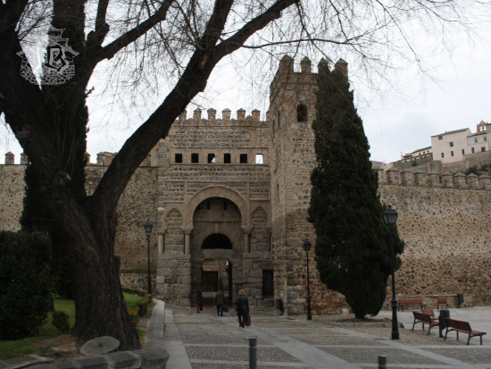
Weather warnings, work, and a nasty stomach bug seemed to conspire against me for a lousy start of the year, and what I had originally planned for the 2nd of January had to be delayed a couple of weeks until I caught a break from everything. Eventually, the plan just became a “grab the backpack and go” when the stars aligned – and actually, I just required one star and the only thing it needed to do was shine. Whilst I’ve been around the reservoir Embalse de Entrepeñas before, I had never been aware of the not-so-hidden hiking route that departs from the parking lot, heading downstream. I found its description in a book about walking routes in the province, it was not a difficult drive, and the route could be expanded to include a couple of spots the guide did not consider.

Spain has long had a complicated relationship with freshwater. Despite being a majorly dry country, it has developed a wide net of water-intensive agricultural hubs. The cyclic droughts and low-quality soils in the centre do not help – the areas with a nice temperate climate and good soils don’t have water. Thus, once the technology was readily available (the first dams date back from the late 19th century), the first Hydrological Plan (Plan Hidrológico Nacional) was developed during the years of Franco’s Dictatorship. The government designed and built an extensive network of reservoirs in order to, well, store freshwater. Water transfers were designed to feed the eastern orchards. Of course, these were controversial on several fronts. First, the environmental one. Second, the social one – once a dam is built and the water rises, it swallows everything that had previously grown on the riverbanks, be it healthy ecosystems, entire villages, or historical buildings. And third, of course, the moral one – dictatorships are not good, so well-meaning people have to oppose anything such a system devises.

In addition, the reservoir Embalse de Entrepeñas has a bit of a bad reputation. During the 1980s it became popularised as an inland sea, along other reservoirs in the Spanish central plateau, as what became known as the Castilian Sea – El Mar de Castilla. However, despite the extensive security network decades of beach tourism had impulsed along the coast, inland water bodies were left unattended. I grew up on reports of people drowning in Entrepeñas. Everybody seemed to know someone who died there. Adult perspective says most people knew the same victim, or they were just repeating hearsay. As a kid, I really believed that the reservoir might actually been an evil entity feeding on swimmers.

The reservoir Embalse de Entrepeñas was built between 1946 and 1952, during Franco’s Dictatorship, but the plan dated back from 1902. The goal was to regulate the flow of River Tagus to keep drinking and agricultural water in storage, along with producing electricity. During the mid-1960s, the 813 square hectometres of water became a holiday spot. However, soon a “ghost” hovered over the reservoir, the dreaded Tagus-Segura Water Transfer, Trasvase Tajo-Segura. The Segura River is used to water the orchards in the east of Spain, but its flow cannot cope with the demand. Thus, water is carried from the Tagus to one of the tributaries of the Segura, in an engineering feat that was built between 1968 and 1971. The transfer established the region of Murcia as a strategic agricultural area. However, it dried up the Tagus reservoirs, killing off the water-tourism, not even mentioning the environmental consequences of the whole project.

However, as tourism dwindled, something else happened. Entrepeñas became a hotspot of conservation success when threatened griffon vultures (Gyps fulvus) started nesting in the rocky walls. Child-me was very concerned about birds of prey going extinct but had no idea about ecology, so I was halfway worried about vultures disappearing, halfway low-key worried they would make a meal out of me. Considering that during a couple of hikes I’ve actually had raptors circling me, child-me might have been onto something.

Back to the present, though. I woke up and even before pulling up the blinds, I looked at the weather app. Being January, the day was going to be cold, but the temperature would not go below zero, and the sky would be clear. To be honest, I was desperate to do basically anything, but at the same time, there was this wave of exhaustion going through me. I kicked myself into gear and got onto the car. I filled up the tank and set on my merry way towards the parking lot / viewpoint that the guidebook described as being “on the right, before the tunnel”. Dear book, there are two tunnels. You mean the second one. If you go right before the first one you end up… somewhere else. Yes, talking from experience. You can turn around in one of the parking lots on the side of the road. If you dare, of course.

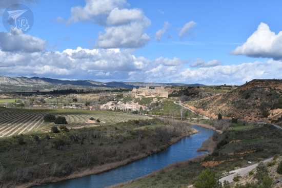
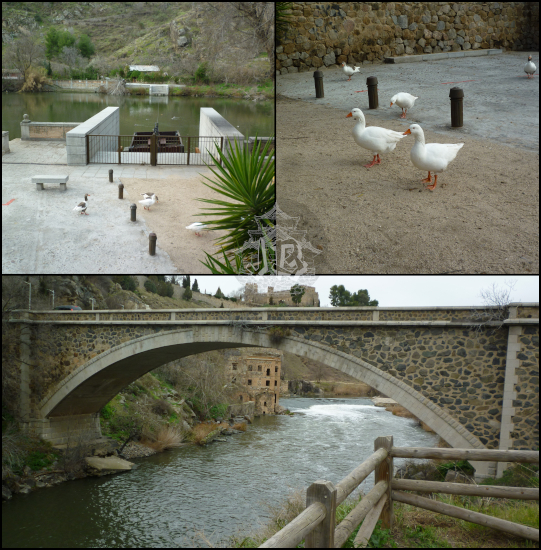
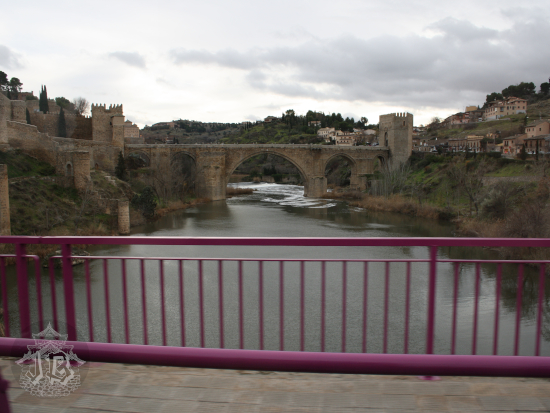
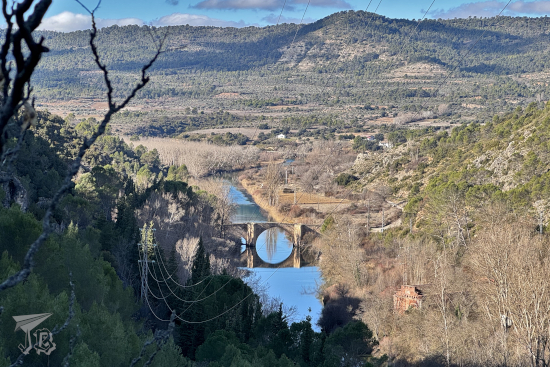
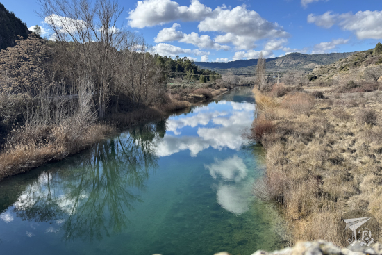
I dared, else I would have had to drive an extra 9 km. I found the almost empty parking lot, parked the car, and set off onto a closed-road-turned-trail. It was around 11:00, the air was crisp and the sun was shining. When I thought in November that hiking season was over, I had not realised there are routes recommended for winter, and this is one of them, as the trees being devoid of leaves allows for a great view of the Romanesque bridge downstream.

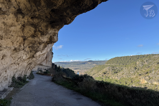
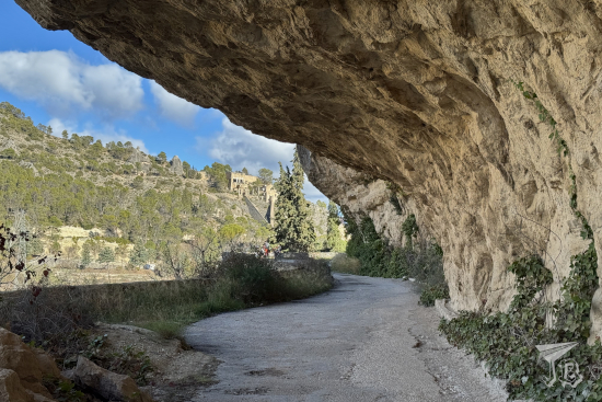
The first part of the hike runs between the river Tagus Río Tajo and a vertical wall, eroded at trail level to form a rock shelter. The vultures were already active, treating me to some nice flights. The trail was slightly downwards, and it did not take long to catch a glimpse of the so-called Roman Bridge – actually Romanesque Puente Románico. This area of Spain tends to confuse Roman and Romanesque. The original bridge was erected in the 14th century, but it was rebuilt in the 19th, and that is the structure which remains today.

Rock shelter formed by brown rock

View from above of the valley, with the river crossed by an old bridge. The arch of the bridge and its reflection create a perfect circle

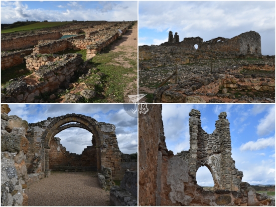
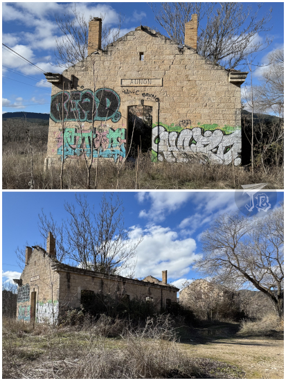
Near the bridge stands the original hydroelectrical station Central Hidroeléctrica de Guadalajara, but it was harder to see it across the river. It was not long before I reached the bridge itself, and the route said to turn right then. Instead, I crossed over and continued downstream, as I had seen that there was an abandoned train station nearby, Antigua Estación de Ferrocarril de Auñón. The original building was part of the former railway network Ferrocarril del Tajuña, a line that was originally designed to join Madrid and Aragón in order to transport people and freight, However, it was eventually dismantled since it was too expensive to maintain and yielded to too little revenue. The station was in use between 1919 and 1953. After 1946, due to the works on the reservoir, Auñón became the terminus. Today, the actual rail is gone, and there are only ruins of the passenger and warehouse buildings, and the loading docks. Unfortunately, the whole thing was covered in graffiti, and the vegetation rather overgrown.

Abandoned hydroelectrical central

Abandoned station building

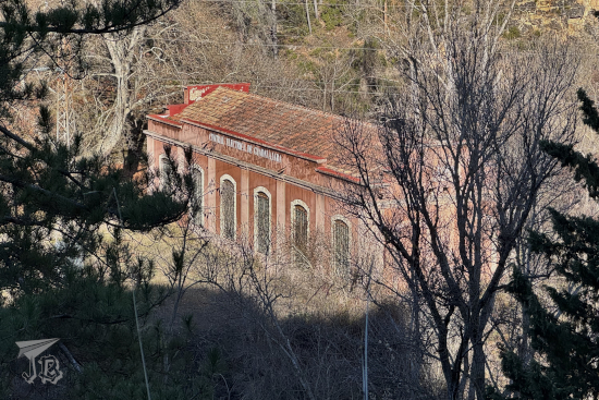
I backtracked and headed upstream. It did not take long to reach the former hydrological station Central Hidroeléctrica de Guadalajara, a brick building erected in 1909. Not much further, I found the remains of the original dam over the Tagus, with a rather impressive water sprout remaining – and a makeshift bridge over the water, made with wooden logs, that I looked, photographed, and no way in hell I was going to try to step on.

Remains of the former dam

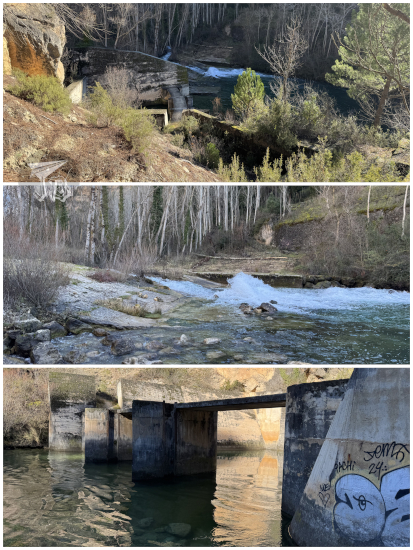
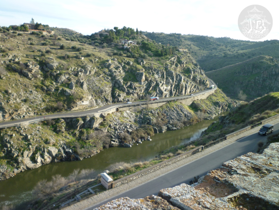
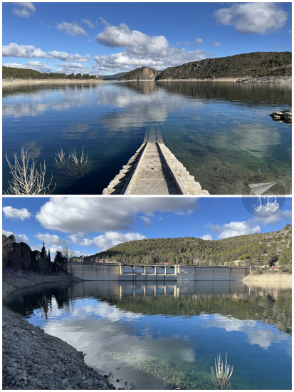
I continued upstream until I reached the modern gravity dam Presa de Buendía, a huge structure made of reinforced concrete that holds back the water. It’s a very different sensation when you look at the dam from this perspective, upwards, from the “empty” side than what I had always experienced – from the top.

Humongous river dam

I turned back towards the bridge, which I had to cross to return to the parking lot. I still had a bit of time, so I wandered towards the actual reservoir area. There’s a structure there that fascinates me… a small building with remains of a railway that goes right into the water. I have never been able to figure out what it was made for.

Tranquil river in a crisp winter morning

Rock shelter alongside a river course

Tranquil reservoir. Some stairs disappear into the water.

And that was it for the day trip, a short hike I dragged for about three hours during the one good weather day we had for a bit and that turned out to be my first outing of 2026. Afterwards, it was just a matter of hopping onto the car and heading back home, feeling recharged.

23rd February 2024: Zorita de Los Canes & Recópolis (Spain)

Zorita de los Canes is a hamlet at the bank of River Tagus, in the middle of nowhere in the Spanish Central Plateau. It was founded as an Almoravid dynasty fortress (alcazaba), however the stones that erected the castle are much, much older. The fortress was built around the 12th – 13th centuries, and although ruined, it used to be visitable – not at the moment though. The stones to build the castle were quarried from an even older settlement, which today is known as the archaeological site of Recópolis.

During the Middle Ages, Zorita was extremely disputed. After the Moors built the alcazaba, the town was taken over by the Christians, then recovered by the Almoravid dynasty, until it was conquered by Christian king Alfonso VII. The village was entrusted to the Order of Calatrava, the first military order to be founded in the Kingdom of Castile, who were to defend it against the Almohad Caliphate.

I’d been wanting to go to Recópolis for a while, and I found out that the archaeological sites in the area are free until the end of the year, so I thought it would make a nice mini-trip. I booked the ticket a few days in advance as it seemed that the weather would be cold but dry, albeit windy. I thought it could be a good chance before fuel prices go up again.

I had an early lunch and drove off with the idea to get to the archaeological site around quarter to three, as I was booked for three o’clock and the ticket said to arrive ten minutes in advance. The drive was a bit faster than I thought, but the Sat-Nav sent me on a completely different route than Google had, which made me a bit insecure about timings. That’s why, even if I saw a couple of villages that looked interesting, I decided not to stop and explore them, I could do it on my way back. Suddenly, the ruined castle came into view. I pulled over in a safe place to admire it and checked the time – I was good. Thus, I drove into Zorita de Los Canes and stopped at a small parking lot at the entrance of the village. I parked next to the river Tagus Río Tajo, which gave me a couple of nice views.

Castle in Zorita de los Canes, atop a hill

Part of the Medieval wall still stands, and access to hamlet’s core is done through an ancient gate, which I was happy to cross on foot. There was a small church, and at the summit of the peak stands the derelict castle Castillo de Zorita de los Canes. I decided not to climb as I knew it was closed, and after a few minutes, I got back into the car and drove off.

River Tagus and Castle in Zorita de los Canes

All in all, I was in town for about a quarter of an hour, and did not drive for longer than three or four minutes before I parked at the entrance of the archaeological site Parque Arqueológico de Recópolis. The interpretation centre was empty and locked, and I was the only car in the parking lot. The time was around 14:30 at that point and I decided to wander around for a bit, as there was what looked like a hiking trail amongst the fields. I found a nice lookout of the castle, but not the ruins themselves.

Zorita de los Canes from far away

The discovery of Recópolis is credited to Juan Catalina García López in 1893. Juan Cabré Aguiló started the excavation in 1945, and found a “little treasure” (tesorillo) of coins from looting (one of them fake). Of Visigoth origin, it predates the Moorish town by a few centuries. It was erected around the year 578 by king Leovigildo in honour of his son Recaredo, who would go on to become the first of the Christian kings of Spain.

The city followed the byzantine pattern. There were two perpendicular streets, one of which lead to the palatial area, with shops to the side. Recópolis became important enough to mint its own coins, but the crisis of the Visigoth state lead to it conquest by the Moors in the 8th century. The city was slowly abandoned and became a quarry for the nearby settlement of Zorita. Later, in the 11th century, Christian settlers built a church and a small village, which had been abandoned by the 15th century.

The whole archaeological area spreads 30 hectares, out of which eight have been excavated. The interpretation centre has a few replicas of artefacts that have been found – due to security concerns, no originals are kept on site. To be honest, I was not surprised – I could have walked into the site and left without anyone stopping or even seeing me. When I arrived, it was me and the vultures, and I had a bit of a flashback to that time at the cave Cueva de los Casares, and even fantasised a little about being alone to explore the site. The guide arrived on time and opened the centre, and I was still the only one there, which was weird – I know for a fact that there were a bunch of reservations for 15:00, but only I showed up. Maybe the others became discouraged because of the weather?

The nice tour guide suggested waiting for a few minutes to give time for others to arrive, and offered me the VR experience. I accepted, of course – I’m not going to turn down such a thing. It was really fun, because you could pick up objects as the local goddess and a little child showed you around a reconstruction of the town, the palace and a glass workshop.

Afterwards, we headed off towards the ruins – nobody else had shown up. The guide offered to let me stay after the tour to take all my pictures so I decided to just listen to him as he explained and pointed to some very interesting details – a bit giddy inside. Would I really be alone eventually? He showed me the church, the palace and the grain silos in the ground, where grain was stored. He also took me to the palace and pointed out the main streets, and taught me how to differentiate the Moorish construction (criss-crossed materials) from the original Visigoth one (parallel architectural stones).

We also chatted a little and I mentioned I hoped it did not rain – he said that it had been threatening rain all week, but it would be all right. I eyed the black cloud approaching and hoped he was right.

Spoiler alert: he was not.

After finishing the guided visit, I was left alone indeed. I went around the main area of the archaeological site, and when I was in the church, the storm broke out. I had an umbrella, but I still got drenched. Interestingly though, even if it was raining and windy, it was suddenly not as cold as before. However, I had to give up eventually, since taking pictures was too difficult. As I decided to return to the visitor centre, the cloud finally moved through, and rain slowed down. I was heading down the hill towards the visitors’ centre when it finally cleared completely. I stopped, wondering whether to leave or come back, and when I looked up I saw a rainbow, sprouting right out of the castle. There were even vultures flying against the retreating cloud. It was really cool.

Rainbow hitting the castle, and a vulture flying

I felt motivated again, so I went back to the ruins of the city to take a few more pictures – after all, it was really cool to be all alone in the archaeological site. I wandered among the houses where it was allowed, and went to the edge of the site to take it all in, then I walked back. As I was in the middle of the street, a griffon vulture circled me a couple of times, maybe wondering if I was food – I think staying where I was taking pictures did not help? It eventually left, and I headed back to the centre, where I arrived just in time to watch the little video documentary about the Visigoth town.

Ruins of Recópolis

Recopolis ruins

Griffon vulture mid-flight

I left afterwards, and I got caught in the storm again – thus I did not stop in any village on the way. The first half of the drive was miserable in the rain, but then it cleared out, and the rest of it was all right. Fortunately, I did not run into too many other cars either. I got home around sunset and went to bed early since I had to wake up early the following day.

Nevertheless, now I’ve got a VIP (VOP? Very only person?) experience, alone in an archaeological site, which is added value to the whole thing and I loved every second of it, even with the rain.

30th December 2013 – 1st January 2014: New Year’s in Toledo (Spain)

30th December 2013: Arrival in Toledo

We took an early train to get to Madrid, and transferred to the high-speed line (AVE) to get to Toledo – the ride from Madrid was barely half an hour. Toledo is known as “the city of the three cultures” as during the Middle Ages, Christians, Muslims and Jews managed to live in peace there, and make it prosper. Today it is a tourist hub in the centre of Spain.

The first thing that we did was head off to the Alcázar (Muslim castle) – although it was originally built by Romans in the third century, its current look is owed to the restoration carried out in the 1540s. However, it had to be restored after the Spanish Civil War. The Siege of the Alcázar was one of the most symbolic victories on the Nationalist band. The Alcázar was under siege during the whole summer by Republicans trying to take it over, but in the end, Nationalist reinforcements arrived, chasing the Republicans away. Today, the Alcázar is an important cultural building (where the bullet holes can still be found) and hosts the Museum of the Army, Museo del Ejército.

From the vantage point of the Alcázar, we could see the Academia de Infantería (Toledo Infantry Academy), built in the 20th century in imitation of the Renaissance and Herrerian style.

We also saw the Castillo de San Servando, the Castle of San Servando, a fortified Knights Templar enclave. Fine, it started off as a regular monastery, but it was later given to the Knights Templar in order to protect the city.

Both buildings are on the other side of the Río Tajo, the Tagus river, the longest river in Spain.

After having lunch and checking into the hotel, we visited the cathedral Catedral Primada Santa María de Toledo (Primate Cathedral of Saint Mary of Toledo). The cathedral, built in Gothic Style, was erected mainly throughout the 13th century, even if it was only finished in the 15th century. It sports two asymmetric towers, well, one tower and a small Mozarabic chapel in place of the other one.

By the time we came out of the cathedral, night had fallen – truth is that we missed a little on the pretty windows due to it being darkish outside already. Nevertheless, this treated us to some nice night views. First of all, of course, the cathedral itself…

The Alcázar once again…

… and the Castle of San Servando.

We then walked through the Plaza de Zocodover, one of the city squares, where the old Muslim for cattle and horses was. The current layout was set in the 16th century after it burnt down in a fire.

We walked around the old town for a while until we found a place to have dinner, a Middle-East restaurant called La Casa de Damasco, one of the few times I’ve had real food from this area. I have to say I really enjoyed it.

31st December 2013: Churches and Birds

We started off the day at the Monasterio de San Juan de los Reyes (Monastery of Saint John of the Monarchs) is an Isabelline style Franciscan monastery. It was founded by the Catholic Monarchs to celebrate the birth of their son along with their victory in the Battle of Toro, in the late 15th century. It has a beautiful Gothic cloister.

Our next stop was one of those things that breaks my brain, a Christian Mosque, Mezquita del Cristo de la Luz. It was built in the year 999 as Bab-al-Mardum mosque, but it was turned into a Christian Church in 1085. I’m torn between rolling my eyes at Religions needing to assert dominance and being grateful the Mosque was preserved for us to visit.

Close to the Mosque stands one of the gates of the old walls, the Puerta del Sol, the Sun Gate, of the city walls.

Our next stop the Iglesia Jesuita de San Ildefonso, a church dedicated to Saint Ildefonsus, the patron saint of the city. Construction started in the early 17th century and ended in the mid 18th century, in the Baroque style.

From the upper towers of the church, there was a great view of Toledo.

We decided to walk down towards the river, Río Tajo, where we met a flock of geese (which I’m happy to report had not lost their heads to any kind of stupid animal-hurting tradition).

As we continued, we walked past a sculpture to Miguel de Cervantes, Estatua de Miguel de Cervantes, the author of the acclaimed “Don Quijote” book. The statue is placed beyond the Arco de la Sangre , the Blood Archway, that leads into the Zocodover Square.

As darkness rose, we had dinner in a Chinese restaurant. While we did, the lights turned on, and the city got ready to welcome the New Year with fireworks.

1st January 2014: Views of Toledo

We slept in, and after an early lunch (Chinese, again, as we were feeling decadent), we booked a ride in the “tourist train” that took us to see some of the most amazing views of the Medieval Town from the vantage points on the other side of the Río Tajo.

On the way back we saw the Puente de Alcántara, a Roman arch bridge built upon the foundation of the city after the Celtic settlement was taken over.

The ride ended up on the other side of the city than the one we had been favouring, so we just walked round the walls that fortify the city, the Murallas de Toledo, which are of Muslim origin over Roman foundations. King Alfonso VI is credited with finishing off the walls, and he named one of the gates after him: Puerta de Alfonso VI.

Another of the gates is the Puerta de Bisagra, the last of the monuments we visited before we headed back home the following morning.

One of the creepiest moments in this trip was realising that our key could open a room which was not ours – we got off on the wrong floor and we went down the corridor to the room door, and opened it. It was not our room. We were very quite put off by this, and it turns out that we had a master key. Finding this was a little freaky, and we tried to complain to the hotel. Furthermore, they wanted to charge us for keeping our luggage for a few hours.

Oh, and I caught a cold during our 31st at night escapade. Because of course I did.